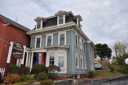
Newport dates to 1761, and 27% of its homes were built before 1940
More historic than 96% of U.S. towns · #16 of 126 in New Hampshire. What drives it
11 places in town are on the National Register, among them a historic district with 16 buildings. Below: 14 old photos and papers, maps from 1884 on, and the census since 1790.
Founding year: Wikidata. First post office: 1812.The full story ↓
History grade
What drives Newport’s History grade
On its age, its old homes and the National Register, Newport is more historic than 96% of U.S. towns, #16 of 126 in New Hampshire. All 3 inputs are above most U.S. towns; its age ranks highest and its National Register listings lowest.
A+
HistoryA character grade: shown, never part of Newport’s overall grade.
New Hampshire towns list more on the Register than most of the country (a typical New Hampshire town has 9.5 per 10,000 residents, the U.S. 2.4), so Newport’s 42.4 sits above most of its state (73% of New Hampshire towns have fewer) while its 27 historic buildings outnumber those of 81% of U.S. towns.
How sure. Graded on any two of the three inputs instead, the letter would range from A to A+. The pre-1940 share is a Census survey estimate (±7.8 points). Two sources give 1761.
Founding year: Wikidata (other dates in Quick answers). Homes: Census ACS 2020–24. National Register: National Park Service, May 2026 list; each listing counted once (boundary changes and added documentation belong to their listing), and a historic district counts its contributing buildings. How TownRatings grades history →
What stands out about Newport’s past
Read from the archive, the National Register and the record. The page puts what stands out first.
Maple StreetNorth NewportPine StreetPinegroveSaint Patricks
US Post Offices dataset (Blevins & Helbock, CC0). Places and cemeteries from the USGS Geographic Names Information System (2021).
Every building
Newport, building by building, 1884–1921
Fire insurance maps drew every building, what it was made of and what it was used for, so insurers could price the risk of fire. Pick a year, then a sheet.
Granted in 1753 by colonial governor Benning Wentworth, the town was named "Grenville" after George Grenville, Prime Minister of Great Britain and brother-in-law of William Pitt. But ongoing hostilities during the French and Indian War, as close as the Fort at Number 4 at Charlestown, delayed settlement. Nevertheless, in 1761 the town was incorporated as "Newport", for Henry Newport, a distinguished English soldier and statesman.
Passages that mention Newport, cut from the printed page as they were published.
The history of Newport, New Hampshire, from 1766 to 18781879 · page 336Read the page →
Read the text
During the year 18 15 he constructed the dam and canal which feed the upper tannery and the Newport and Eagle mills. On the canal he built a cotton factory and linseed oil-mill ; and about the same time he built a grist-mill and saw-mill at the grist-mill dam below. About the year 1819 he purchased all the water-power at Sunapee Harbor, and built there a gristmill, saw-mill, and carding-mill.
Text read by machine from the scan; it may contain errors.
The history of Newport, New Hampshire, from 1766 to 18781879Read the page →
Read the text
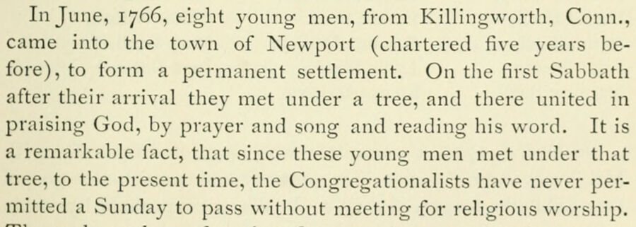
In June, 1766, eight young men, from Killingworth, Conn., came into the town of Newport (chartered five years before), to form a permanent settlement. On the first Sabbath after their arrival they met under a tree, and there united in praising God, by prayer and song and reading his word. It is a remarkable fact, tliat since these young men met under that tree, to the present time, the Congregationalists have never permitted a Sunday to pass without meeting for religious worship.
Text read by machine from the scan; it may contain errors.
Scans and text from the Internet Archive. Books published in 1930 or earlier, which are in the public domain.
Timeline
Newport, 1761 to 1964
Woven from the archive, old maps, post office records, the National Register and the people born here.
Nothing in the archives for these yearsWeddings on Main Street, storms, parades, school pictures, the old store. If it’s in your family album, it belongs here.
Nothing in the archives for these yearsWeddings on Main Street, storms, parades, school pictures, the old store. If it’s in your family album, it belongs here.
In 1761, according to Wikidata. Newport’s post office opened in 1812, and the first U.S. census counted 780 people here in 1790.
How does Newport rank for history?
Newport is more historic than 96% of U.S. towns, #16 of 126 in New Hampshire. The History grade combines the town’s founding era, the share of homes built before 1940 and its National Register listings. It’s a character grade, so it isn’t part of the overall grade. How it works.
What is on the National Register in Newport?
11 listings: 8 buildings, among them the Sullivan County Courthouse (listed 1973, the first), 1 historic district, the Newport Downtown Historic District, with 16 contributing buildings, and 2 structures. 27 historic buildings in all.
How old are the homes in Newport?
27% of Newport’s homes were built before 1940 (Census estimate, ±7.8 points), against a typical 17% for a New Hampshire town; the median home was built in 1964.
Founding dates: Wikidata, Wikipedia, the U.S. post office records of Blevins & Helbock (CC0) and the Census. Homes by year built: Census ACS 2020–24. National Register of Historic Places: National Park Service (list of May 22, 2026). Old photos, postcards and papers: Wikimedia Commons, the Library of Congress and other public archives, credited on each item’s page. Maps: U.S. Geological Survey historical topographic maps (via Esri) and Sanborn fire-insurance maps (Library of Congress). History text and census tables: Wikipedia (CC BY-SA 4.0). Places that used to be: USGS Geographic Names Information System (2021).
From Wikimedia Commons (21), Wikidata (3), the National Register of Historic Places (11), Wikipedia, Wikidata and Wikipedia for famous people, U.S. Geological Survey historical maps, U.S. Census counts (via Wikipedia), the US Post Offices dataset (Blevins & Helbock), the USGS Geographic Names Information System, Sanborn fire insurance maps (Library of Congress) and old county and town histories (Internet Archive). Archive images are copied here with their credits and licenses, shown on each photo’s page. Refreshed monthly.


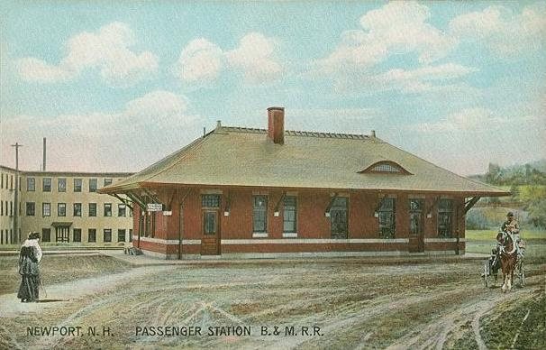






 1834
 1906
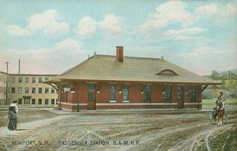 1907
 c. 1908
 1908
 1909
 c. 1909
 1914
 1918
 1984
 2013
 2013
 2013
 2009
 2009
 2009
 2007