Guest, Sign inJoin

Post to Rochester

We’ll email a one-tap link to publish your post. No password, and nothing is public until you click it.
Already a member? Sign in
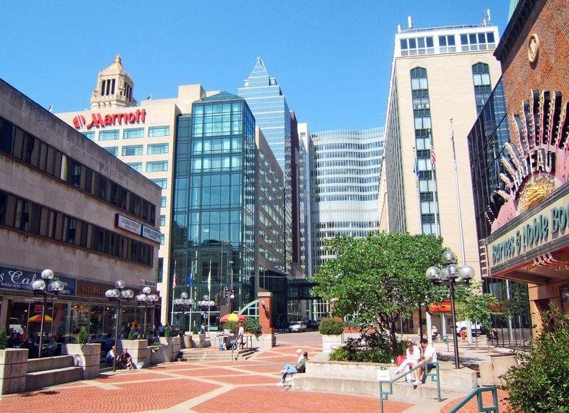
Downtown Rochester, MN-Peace PlazaPhoto: cjohnson7 · CC BY 2.0
A−Outdoors
Outdoors in Rochester

97% of residents live within a half mile of a park in Rochester

The biggest trail networks: Quarry Hill Park (7.4 mi), Willow Creek Reservoir Park (3 mi), Essex Park (3 mi). 3,724 acres are parks and preserves, 30 per 1,000 residents. 34 miles of mapped trail cross Rochester, 0.6 per square mile of land.

Ahead of 81% of U.S. towns · #102 of 274 in Minnesota. What drives it

Conserved land
4%
1,492 acres · of 56.8 sq mi of land
Trails
34 mi
0.6 per sq mi of land
Park land
3,724 ac
30 acres per 1,000 residents
Near a park
97%
of residents within ½ mile
Bike routes
200 mi
43 mi lanes · 149 mi paths
Lakes & rivers
23
5 beaches

What kind of outdoors town is Rochester?

Read from the map. The page puts what stands out first.

Outdoors grade

How much outdoors does Rochester have?

On conserved land, trails, park land and how close residents live to a park, Rochester is ahead of 81% of U.S. towns, #102 of 274 in Minnesota. All four inputs are above most U.S. towns; the share of residents near a park ranks highest, conserved land lowest.

A−
OutdoorsA character grade: shown, never part of Rochester’s overall grade.
All U.S. towns we grade (21,298)Ahead of 81%
LessMore
Minnesota towns of 2,500+ (274)Ahead of 63%

Among the 400 U.S. cities of 100,000 or more, Rochester ranks #182 on Outdoors.

How sure. Graded on any three of the four inputs instead, the letter would range from B+ to A. Trails and many small parks come from OpenStreetMap, mapped by volunteers, so coverage varies from town to town; the half mile is a straight line from each census block, so a river or highway in the way isn’t counted against it.

PAD-US, OpenStreetMap (© OpenStreetMap contributors), Census 2025 Gazetteer and 2020 blocks; details in Sources below. How TownRatings grades the outdoors →

The map

Conserved land, trails & bike routes

Tap a number to zoom to a park. Tap a layer to hide it.

12345678
Easements protect land from building but are usually private.© OpenStreetMap contributors · USGS PAD-US
Places to walk

Pick a walk

The longest trail network is Quarry Hill Park, with 7.4 miles. Directions go to the nearest trailhead or public parking.

Quarry Hill Park

Park
248 acres7.4 mi of trail
Quarry Ruins TrailWoodland TrailSavanna TrailWinter Sports Trail+1
Dog rules not recorded
Directionsto the parking lot

Willow Creek Reservoir Park

Park
196 acres3 mi of trail
Dog rules not recorded
Directionsto the parking lot

Essex Park

Park
167 acres3 mi of trail
Dog rules not recorded
Directionsto the parking lot

Cascade Meadows Wetlands

Park
114 acres1.8 mi of trail
Dog rules not recorded
Directionsto the parking lot

Foster Arend Park

Park
53 acres1.2 mi of trail
Dog rules not recorded
Directionsto the parking lot

Gamehaven Reservoir Park

Managed by City of Rochester
299 acres1.1 mi of trail
3.5 Mile Border Trail
Dog rules not recorded
Directionsto the parking lotWebsite ↗

Indian Heights Park

Park
34 acres1.1 mi of trail
Dog rules not recorded
Directionsto the parking lot

Parkwood Hills Park

Park
24 acres0.9 mi of trail
Stream TrailWinter Sports TrailDevil's Colon
Dog rules not recorded
Directionsto the parking lot
All 115 parks & preserves
Quarry Hill Park248 acres · 7.4 mi of trail
Directions
Willow Creek Reservoir Park196 acres · 3 mi of trail
Directions
Essex Park167 acres · 3 mi of trail
Directions
Cascade Meadows Wetlands114 acres · 1.8 mi of trail
Directions
Foster Arend Park53 acres · 1.2 mi of trail
Directions
Gamehaven Reservoir Park299 acres · 1.1 mi of trail · City of Rochester
Directions
Indian Heights Park34 acres · 1.1 mi of trail
Directions
Parkwood Hills Park24 acres · 0.9 mi of trail
Directions
Jean & Carl Frank Canine Park9 acres · 0.5 mi of trail
Directions
Northern Hills Prairie Park10 acres · 0.4 mi of trail
Directions
Recreation Center Park36 acres · 0.3 mi of trail
Directions
Zumbro South Gardens28 acres · 0.3 mi of trail
Directions
Thompson Mill Race Park16 acres · 0.3 mi of trail
Directions
Northern Heights Park68 acres · 0.2 mi of trail
Directions
Riverview West Park45 acres · 0.2 mi of trail
Directions
Soldiers Field Memorial Park42 acres · 0.2 mi of trail
Directions
Silver Lake Park131 acres · 0.1 mi of trail
Directions
Woodside Park114 acres · 0.1 mi of trail
Directions
Olmsted County Fairgrounds59 acres · 0.1 mi of trail
Directions
Zumbro South Park49 acres · 0.1 mi of trail
Directions
Baihly Meadows Park9 acres · 0.1 mi of trail
Mayo Park5 acres · 0.1 mi of trail
Directions
Younge Park4 acres · 0.1 mi of trail
Peace Plaza2 acres · 0.1 mi of trail · City of Rochester
Directions
Crescent Park1 acres · 0.1 mi of trail
Cascade Lake Park213 acres
Directions
KR-6 Reservoir and Fox Trails (UNDEVELOPED)133 acres
Bear Creek Park127 acres
Directions
Gordon W Yeager Wildlife Management Area, South East Unit108 acres · Minnesota Department of Natural Resources
Directions
Gordon W Yeager Wildlife Management Area, South West Tract105 acres · Minnesota Department of Natural Resources
Directions
McQuillan Sports Complex82 acres
Directions
Smekta Park60 acres
Directions
Douglas State Trail58 acres
Directions
Eastwood Park54 acres
Directions
Fuad Mansour Sports Complex52 acres
Directions
I.B.M. Park (Private)51 acres
Directions
Schmidt Park44 acres · City of Rochester
Directions
John Withers Sports Complex43 acres
Directions
Mayowood Corridor Park41 acres
Slatterly Park36 acres
Directions
Rochester Youth Baseball Complex36 acres
Directions
Rev. Dr. Martin Luther King Jr. Park34 acres
Directions
Gordon W Yeager Wildlife Management Area, North West Unit32 acres · Minnesota Department of Natural Resources
Directions
Summit Pointe Park29 acres
Kutzky Park26 acres
Directions
Northern Heights Village Park23 acres
Homestead Park22 acres
Directions
Joyce Park22 acres
Badger Ridge Park22 acres
Directions
Lincolnshire Park20 acres
Directions
Southern Woods Park20 acres
Directions
Weatherstone Park19 acres
Kings Run Park19 acres
Cook Park18 acres
Directions
Girl Scouts17 acres
Rochester Youth Fastpitch Complex17 acres
Directions
Elton Hills Run Park13 acres
Ridge View Manor Park11 acres
Allendale Park11 acres
Directions
Manor Park11 acres
Directions
White Oaks Park11 acres
Directions
Gordon W Yeager Wildlife Management Area, North East Unit10 acres · Minnesota Department of Natural Resources
South Pointe Park10 acres
Directions
Judd Park9 acres
Plummer House9 acres
Directions
Fox Valley Park9 acres
Hart Farm Park8 acres
Viking Park8 acres
Directions
Diamond Ridge West Park (UNDEVELOPED)7 acres
Lutheran Park7 acres
Directions
Harvest View Park7 acres
Directions
Morris Hills Park (UNDEVELOPED)7 acres
Northern Heights East Park7 acres
Directions
Badger Hills Park7 acres
Goose Egg Park7 acres
Directions
Scenic Oak Park6 acres
North Park6 acres
Century Hills Park6 acres
Directions
Parkeside Park6 acres
Directions
Wedgewood Hills Park6 acres
Pinewood Hills Park (UNDEVELOPED)6 acres
Pine Ridge Estates Park6 acres
St. Mary's Park6 acres
Directions
Nachreiner Park6 acres
Directions
Meadow Park5 acres
Directions
Eagle Ridge Park5 acres
Directions
Emerald Hills Park5 acres
Directions
Stonehedge Estates Park4 acres
Elmcroft Park4 acres
Arborglen Park4 acres
Directions
Diamond Ridge Park4 acres
Southern Hills Park4 acres
The Gardens Park4 acres
Directions
Graham Arena Complex3 acres
Directions
Valleyside Estates Park3 acres
Meadow Park Estates Park3 acres
Directions
Cimarron Park3 acres
Pinewood Ridge Park3 acres
Northgate Park3 acres
Bamber Ridge Park3 acres
Mayowood Corridor County Park2 acres
Autumn Ridge Park2 acres
Directions
Glendale Hills Park2 acres
Meadow Lakes Park2 acres
Central Park2 acres
Directions
Mohn Park2 acres
Dinah Olin Bird Sanctuary2 acres
Directions
Elton Hills Park1 acres
Whiting Lane Park1 acres
Directions
private park1 acres
Directions
Rolling Green Park1 acres
Directions
Meadowbrook Park1 acres
Courtyard1 acres
Hazama Gateway Plaza1 acres
Directions
Friendship Park1 acres
Directions
Who protects it

1,492 conserved acres

4% of Rochester’s land. Who manages Rochester’s conserved land, from the USGS Protected Areas Database. Approximate, because parcels can overlap.

Town or city1,262 ac
State fish & wildlife187 ac
County40 ac
Private owners2 ac
Local Park · 1,304 acState Conservation Area · 187 ac
The biggest protected parcels
Parcel (PAD-US)Managed byAcresPublic access
Gordon W. Yeager State Wildlife Management Area
State Conservation Area
State fish & wildlife187Restricted
Zumbro Park
Local Park
Town or city112Open
Woodside Park
Local Park
Town or city108Open
Foster Arend Park
Local Park
Town or city53Open
Smetka Park
Local Park
Town or city53Open
Roy Watson Youth Sports Complex
Local Park
Town or city53Open
Cascade Lake Park
Local Park
Town or city48Open
Silver Lake Park East
Local Park
Town or city41Open
Mayowood Corridor County Park
Local Park
County40Open
Mcquillan Fields
Local Park
Town or city39Open

5 smaller protected places aren’t shown.

Things to do

232 places to go in Rochester

Beaches, playgrounds, peaks, falls and more. Pick a kind.

Playgrounds in Rochester
(private)
Directions
Air Insanity
Directions
Brookestone Park
Directions
Emerald Hills PlaygroundIn Emerald Hills Park
Directions
Greystone Tot Lot
Directions
Kidstruction (Opening soon)
Directions
Playground (Private)
Directions
Playgrounds (3)In Schmidt Park
Directions
5 more playgrounds
Roy Sutherland PlaygroundIn Soldiers Field Memorial Park
Directions
Sky Zone
Directions
Three LinksIn Silver Lake Park
Directions
Tot LotIn Southern Woods Park
Directions
Tot LotIn South Pointe Park
Directions

193 playgrounds are on OpenStreetMap in all; the list shows named ones from the first 30.

Trails & water

11 named trails and 23 lakes & rivers

Named trails
Open to bikes · 4.5 miUnpaved · 21.4 mi
Quarry Ruins Trail1.7 mi
Woodland Trail1.7 mi
Winter Sports Trail1.4 mi
Savanna Trail1.3 mi
Stream Trail0.5 mi
Pond/Prairie Trail0.5 mi
3.5 Mile Border Trail0.3 mi
Silver Creek Trail0.3 mi
Reservoir Drive Southwest0.1 mi
Devil's Colon0.1 mi
1 more trails
Walking path
0.1 mi
Lakes & rivers tap for directions
Biking & sports

200 miles of bike routes

Bike lanes are often missing from the map in smaller towns, so that number is likely low.

43 mi
painted or protected bike lanes
149 mi
off-road bike paths
7.8 mi
shoulders & shared lanes
Courts & fields
89Baseball
74Tennis
67Soccer
25Basketball
16Volleyball
9Football
6Beach volleyball
6Tracks

Includes school and college facilities, which aren’t always open to the public.

History along the way

13 places on the National Register, one a National Historic Landmark

The country’s official list of places worth saving (National Park Service). The map also marks 9 historic points from OpenStreetMap: plaques, memorials and old buildings.

History →
★
Mayo Clinic BuildingsNational Historic Landmark · Building · listed 1969
About it
Mayowood Historic DistrictDistrict · listed 1970
About it
Dr. William J. Mayo HouseBuilding · listed 1975
About it
Henry S. Plummer HouseBuilding · listed 1975
About it
Toogood BarnsBuilding · listed 1975
About it
Rochester Public LibraryBuilding · listed 1980
About it
Chateau Dodge TheatreBuilding · listed 1980
About it
Rochester ArmoryBuilding · listed 1980
About it
Timothy A. Whiting HouseBuilding · listed 1980
About it
Avalon HotelBuilding · listed 1982
About it
Pill Hill Residential Historic DistrictDistrict · listed 1990
About it
Dr. Donald C. Balfour HouseBuilding · listed 2004
About it

1 more on the History page.

When to get out

The walking year in Rochester

NOAA’s 1991–2020 normals for the town and the daylight at its latitude. Outlined months have long days, highs of 59 to 86 °F and little rain for the place.

JanFebMarAprMayJunJulAugSepOctNovDec
Daylight (h)9.210.411.813.414.715.515.214.012.410.99.68.9
High (°F)242841566978827973594229
Rain (in)1.01.02.03.54.55.44.44.43.72.51.81.2

January is the driest month (1.0 in) and July the warmest (highs of 82 °F). 5.4 inches fall in June, the wettest month. The climate in Rochester →

Next door

Rochester and its neighbors

Rochester has the most mapped trails of the 7 towns around it. Tap a town to see its outdoors.

TownConserved
of land
Trail mi
per sq mi
Park acres
per 1,000
Near a park
½ mile
Outdoors
Rochester4%0.63097%A−
Cascade Townshipunder 1%under 0.11652%C−
Rochester Township1%0.14521%C
Haverhill Township2%0.120512%C+
Marion Township1%0.51589%C+
High Forest Township— not graded: under 1,000 residents or part of its town
Kalmar Townshipunder 1%0.353730%C+

The four inputs of the Outdoors grade, from the engine; shares are of land, not water.

Questions about parks and trails in Rochester

Where can I hike in Rochester?

The longest trail networks: Quarry Hill Park, 7.4 miles; Willow Creek Reservoir Park, 3 miles; Essex Park, 3 miles; Cascade Meadows Wetlands, 1.8 miles. Each one is on the map above, with directions to the nearest trailhead or parking.

How much of Rochester is conserved land?

4% of its land, against a typical 5% for a Minnesota town and 4% nationally (PAD-US). Conserved doesn’t always mean open to visitors: easements are usually private land.

Are dogs allowed on Rochester’s trails?

Quarry Hill Park and Willow Creek Reservoir Park don’t have dog rules recorded on the map; check the signs at the trailhead.

Where can I bike in Rochester?

200 miles of bike routes are on the map: 43 of painted or protected lanes, 149 of off-road paths and 7.8 of shoulders and shared lanes.

Is there public land near Rochester?

8,038 acres of parks and open public land lie inside Rochester or within 10 miles of it (PAD-US), 3,724 of them inside the city line.

How much outdoors does Rochester have?

Ahead of 81% of U.S. towns on the Outdoors grade, #102 of 274 in Minnesota. The grade combines the share of land that is conserved, miles of mapped trail per square mile of land, park acres per 1,000 residents and the share of residents within a half mile of a park. It’s a character grade, so it isn’t part of the overall grade. How it works.

Trail talk

Conditions, parking and favorite walks from Rochester neighbors.

Town Square →
Share a tip
Sources

Where this page comes from

Conserved and public land: USGS Protected Areas Database of the United States (PAD-US), service updated July 2026. Parks, trails, playgrounds, beaches and other places: OpenStreetMap (© OpenStreetMap contributors, ODbL), map data as of 2026-10-28. Land and water area: Census 2025 Gazetteer. Residents near a park: 2020 Census blocks. National Register: National Park Service. How TownRatings grades the outdoors →