Guest, Sign inJoin

Post to Rumford

We’ll email a one-tap link to publish your post. No password, and nothing is public until you click it.
Already a member? Sign in
A+History
History · Rumford

Rumford dates to 1782, and 42% of its homes were built before 1940

More historic than 97% of U.S. towns · #13 of 143 in Maine. What drives it

11 places in town are on the National Register, among them three historic districts with 90 buildings between them. Below: 7 old photos and papers, maps from 1923 on, and the census since 1800.

1782founded
11on the National Register
42%homes built before 1940
7old photos & papers
18famous people
From Rumford’s archive · credits on each photo
Quick answers

How Rumford began

When was Rumford founded?

1782

Rumford dates its founding to 1782 (Wikidata). The census first counted it in 1800.

First census: 262 in 18002020 census: 5,858244 years

How historic is Rumford?

A+

More historic than 97% of U.S. towns, on its age, its old homes and the National Register.

What drives the grade ↓
Founding year: Wikidata. First post office: 1815.The full story ↓
History grade

What drives Rumford’s History grade

On its age, its old homes and the National Register, Rumford is more historic than 97% of U.S. towns, #13 of 143 in Maine. All 3 inputs are above most U.S. towns; its share of homes from before 1940 ranks highest and its age lowest.

A+
HistoryA character grade: shown, never part of Rumford’s overall grade.
All U.S. towns we grade (21,289)Ahead of 97%
NewerOlder
Maine towns of 2,500+ (143)Ahead of 92%

Maine towns list more on the Register than most of the country (a typical Maine town has 15.9 per 10,000 residents, the U.S. 2.4), so Rumford’s 165 sits above most of its state (92% of Maine towns have fewer) while its 98 historic buildings outnumber those of 89% of U.S. towns.

NoteThe founding year comes from Wikidata alone; no second source gives 1782.
How sure. Graded on any two of the three inputs instead, the letter would range from A to A+. The pre-1940 share is a Census survey estimate (±6.3 points).

Founding year: Wikidata (other dates in Quick answers). Homes: Census ACS 2020–24. National Register: National Park Service, May 2026 list; each listing counted once (boundary changes and added documentation belong to their listing), and a historic district counts its contributing buildings. How TownRatings grades history →

What stands out about Rumford’s past

Read from the archive, the National Register and the record. The page puts what stands out first.

★ What stands out · Places that used to be

Lost post offices, old corners, places now gone and burying grounds

Rumford’s post office has been open since 1815. Five other post offices opened and closed inside today’s town.

Rumford
1815–today
East Rumford
1823–1909
Rumford Center
1849–today
Rumford Point
1850–today
North Rumford
1868–1936
South Rumford
1890–1900
Rumford Falls
1892–1908
Rumford Corner
1908–1912
18101920today
Hamlets and corners on the map
Abbotts MillRumford CenterRumford CornerRumford PointSmith CrossingSouth RumfordVirginia
Gone or out of use
Mechanic Instituteschool
12cemeteries and burying grounds inside Rumford
Abbotts MillsEast EllisEast RumfordGloverLower West EllisRumford CenterRumford CornerRumford PointSaint JohnsSunnysideUpper West EllisWyman

US Post Offices dataset (Blevins & Helbock, CC0). Places and cemeteries from the USGS Geographic Names Information System (2021).

On the National Register

11 listings protect 98 historic buildings

The country’s official list of buildings and places worth saving.

places listed
11
National Historic Landmarks
0
none yet
historic buildings protected
98
each building in a district counts
first listed
1974
Strathglass Park District
All 11 listings

National Park Service, National Register of Historic Places. Photos from Wikimedia Commons, credited on each place’s page.

People over time

Rumford, census by census

02,0004,0006,0008,00010,00018001850190019502000Peak: 10,340

Peaked at 10,340 in 1930; 5,858 people lived here in 2020.

23 censuses, 1800–2020.

U.S. Census Bureau decennial counts, from the census table on Rumford’s Wikipedia page.

The story

How Rumford came to be

From Wikipedia’s history of Rumford.

Read it all →

Originally called New Pennacook Plantation, the township was granted in 1779 to Timothy Walker, Jr. and associates of Concord, New Hampshire. Both Pennacook and Rumford are former names of Concord, from which many early settlers arrived. The first pioneers, however, were Jonathan Keyes and his son Francis in 1782 from Shrewsbury, Massachusetts. Incorporated in 1800, the town would later annex land from Peru, Maine, and Franklin Plantation.

Text from Wikipedia, licensed CC BY-SA 4.0.

From the old history books

What they wrote about Rumford, 1879–1890

Passages that mention Rumford, cut from the printed page as they were published.

for the protection of the bridge, providing a fine of three dollars for crossing it faster than a walk. March 23, 1839, an act was passed increasing the rates of toll, and making the rates at Bethel, Rumford and Jay, uniform. Tlie bridge at Jay was built by the "Oxford Bridge Association" This cons…
History of Rumford, Oxford County, Maine, from its first settlement in 1779, to the present time1890 · page 224Read the page →
Read the text

for the protection of the bridge, providing a fine of three dollars for crossing it faster than a walk. March 23, 1839, an act was passed increasing the rates of toll, and making the rates at Bethel, Rumford and Jay, uniform. Tlie bridge at Jay was built by the "Oxford Bridge Association" This constitutes all the legislation with regard to the Rumford bridge, nor was this last necessary, for January 26, 1839, this bridge, the one at Bethel and several others on the Androscoggin below, were swept away by a winter freshet.

Text read by machine from the scan; it may contain errors.
|HE parent town of Rumford, beautifully situated on the banks of the Merrimac, was Concord, in the State of New Hampshire, and from that town came many of the early settlers. A brief sketch of early Concord, is therefore essential to a clear comprehension of the causes that led to the settlement of…
History of Rumford, Oxford County, Maine, from its first settlement in 1779, to the present time1890 · page 5Read the page →
Read the text

|HE parent town of Rumford, beautifully situated on the banks of the Merrimac, was Concord, in the State of New Hampshire, and from that town came many of the early settlers. A brief sketch of early Concord, is therefore essential to a clear comprehension of the causes that led to the settlement of Rumford. The long controversy between the Masonian Proprietors of New Hampshire and the Government of the Massachusetts Bay, respecting the division line between the two Provinces, is recorded in history, and

Text read by machine from the scan; it may contain errors.
settled 1781, incorporated 1796, Paris (No. 4),* settled 1779, incorporated 1793, Porter (Portersfield),* settled 1784, incorporated 1807, Rumford (New Penacook),* settled 1777, incor. 1800, Sumner (West Butterfield), settled 1783, incor. 1798, Waterfordji settled 1775, incorporated 1797, 243 530
The history of Waterford, Oxford County, Maine, comprising Historical address, by Henry P. Warren1879 · page 69Read the page →
Read the text

settled 1781, incorporated 1796, Paris (No. 4),* settled 1779, incorporated 1793, Porter (Portersfield),* settled 1784, incorporated 1807, Rumford (New Penacook),* settled 1777, incor. 1800, Sumner (West Butterfield), settled 1783, incor. 1798, Waterfordji settled 1775, incorporated 1797, 243 530

Text read by machine from the scan; it may contain errors.

Scans and text from the Internet Archive. Books published in 1930 or earlier, which are in the public domain.

Timeline

Rumford, 1782 to 1973

Woven from the archive, old maps, post office records, the National Register and the people born here.

  1. 18th century
  2. 1782
    FoundingRumford is established
  3. 19th century
  4. 1815Post officeThe Rumford post office opens
  5. 1823Post officeThe East Rumford post office opens
  6. 1849Post officeThe Rumford Center post office opens
  7. 20th century
  8. 1901Born hereFrank Churchill is born here
  9. 1903BuiltRumford Public Library is built
  10. 1906BuiltRumford Falls Power Company Building is built
  11. 1906BuiltStrathglass Building is built
  12. 1907In the archiveStrathglass Building
  13. 1909Post officeThe East Rumford post office closes
  14. 1910In the archiveBirdseye view Strathglass Park Rumford Maine early 20th
  15. 1914Born hereEdmund Muskie is born here
  16. 1927On the mapFirst mapped by the U.S. Geological Survey
  17. 1929In the archiveDuration Curves Androscoggin River at Rumford (Falls,), ME. (Basin Area 2090 Sq. Miles)
  18. 1930CensusPopulation peaks at 10,340
  19. 1952Born hereJeb Bradley is born here
  20. 1969Born hereRebecca Martin is born here
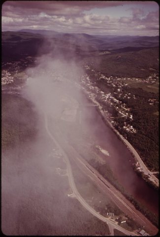
  21. 1973In the archiveRUMFORD AND THE ANDROSCOGGIN RIVER SEEN FROM THE AIR EMISSION COMES FROM THE CHIMNEYS OF …
By decade

Rumford, decade by decade

4 decades in the archive, from the 1900s to the 1970s. Scroll each row; tap a photo for its story.

On the map

Rumford on the map, 1927 to 1969

Every edition of the U.S. Geological Survey’s map of Rumford. Tap a year, or press play to watch the town change.

Rumford on the 1927 USGS mapRumford on the 1930 USGS mapRumford on the 1969 USGS map1927Rumford sheet · 1:62,500

U.S. Geological Survey historical topographic maps (public domain), via Esri’s collection of the scans. The red ring marks the center of Rumford.

Every building

Rumford, building by building, 1923

Fire insurance maps drew every building, what it was made of and what it was used for, so insurers could price the risk of fire. Pick a sheet.

Rumford fire insurance map, 1923, sheet 11923Sheet 1 of 19

Sanborn Map Company, via the Library of Congress. Editions published in 1930 or earlier, which are in the public domain.

Then & now

Stand where they stood

No then-and-now pairs yet. Take a photo from the same spot as an old one and they appear here side by side.

Strathglass Building
Retake this viewStrathglass Building, 1907

Find the spot, match the angle, and add your photo. It becomes the first then-and-now pair on Rumford’s page.

Retake this view · +15
Famous people

18 famous people were born in Rumford

Writers, athletes, leaders and more, ranked by how widely they’re known.

See all →
Help out

Finish Rumford’s story

Most archives stop around 1920. The photos from after that are in family albums, not libraries.

Decades since 1900 with photos
00s10s20s30s40s50s60s70s80s90s
4 of 10 decades. The empty ones are waiting for someone’s album.
Stories next door

History across the town line

Each neighbor’s History grade, on the same three inputs.

Questions about Rumford’s history

What year was Rumford founded?

In 1782, according to Wikidata. Rumford’s post office opened in 1815, and the census of 1800 counted 262 people here.

How does Rumford rank for history?

Rumford is more historic than 97% of U.S. towns, #13 of 143 in Maine. The History grade combines the town’s founding era, the share of homes built before 1940 and its National Register listings. It’s a character grade, so it isn’t part of the overall grade. How it works.

What is on the National Register in Rumford?

11 listings: 8 buildings and 3 historic districts, the Strathglass Park District, the Rumford Falls Paper Company Historic District and the Rumford Commercial Historic District, with 90 contributing buildings. 98 historic buildings in all.

How old are the homes in Rumford?

42% of Rumford’s homes were built before 1940 (Census estimate, ±6.3 points), against a typical 19% for a Maine town; the median home was built in 1947.

Memory lane

What the archives can’t tell you, neighbors can.

Town Square →
Start a conversation
Sources

Where this page comes from

Founding dates: Wikidata, Wikipedia, the U.S. post office records of Blevins & Helbock (CC0) and the Census. Homes by year built: Census ACS 2020–24. National Register of Historic Places: National Park Service (list of May 22, 2026). Old photos, postcards and papers: Wikimedia Commons, the Library of Congress and other public archives, credited on each item’s page. Maps: U.S. Geological Survey historical topographic maps (via Esri) and Sanborn fire-insurance maps (Library of Congress). History text and census tables: Wikipedia (CC BY-SA 4.0). Places that used to be: USGS Geographic Names Information System (2021).

From Wikimedia Commons (21), Wikidata (3), the National Register of Historic Places (11), Wikipedia, Wikidata and Wikipedia for famous people, U.S. Geological Survey historical maps, U.S. Census counts (via Wikipedia), the US Post Offices dataset (Blevins & Helbock), the USGS Geographic Names Information System, Sanborn fire insurance maps (Library of Congress) and old county and town histories (Internet Archive). Archive images are copied here with their credits and licenses, shown on each photo’s page. Refreshed monthly.