On its age, its old homes and the National Register, Penobscot is more historic than 65% of U.S. towns. Its share of homes from before 1940 holds the grade up; its National Register listings pull it down.
B+
HistoryA character grade: shown, never part of Penobscot’s overall grade.
Maine towns list more on the Register than most of the country (a typical Maine town has 15.9 per 10,000 residents, the U.S. 2.4), so Penobscot’s 0.0 sits below most of its state (10% of Maine towns have fewer) while its 0 listings outnumber those of 23% of U.S. towns.
NoteThe founding year comes from Wikidata alone; no second source gives 1787.
How sure. Graded on any two of the three inputs instead, the letter would range from C+ to A. The pre-1940 share is a Census survey estimate (±8.3 points).
Founding year: Wikidata (other dates in Quick answers). Homes: Census ACS 2020–24. National Register: National Park Service, May 2026 list; each listing counted once (boundary changes and added documentation belong to their listing), and a historic district counts its contributing buildings. How TownRatings grades history →
What stands out about Penobscot’s past
Read from the archive, the National Register and the record. The page puts what stands out first.
US Post Offices dataset (Blevins & Helbock, CC0). Places and cemeteries from the USGS Geographic Names Information System (2021).
People over time
Penobscot, census by census
Peaked at 1,557 in 1860; 1,136 people lived here in 2020.
24 censuses, 1790–2020.
U.S. Census Bureau decennial counts, from the census table on Penobscot’s Wikipedia page.
On the map
Penobscot on the map, 1904 to 1981
Every edition of the U.S. Geological Survey’s map of Penobscot. Tap a year, or press play to watch the town change.
1904Blue Hill sheet · 1:62,500
U.S. Geological Survey historical topographic maps (public domain), via Esri’s collection of the scans. The red ring marks the center of Penobscot.
The story so far
Penobscot, in brief
Wikipedia doesn’t have a history of Penobscot yet. The photos, dates and memories neighbors add here are how it gets written.
Penobscot is a town in Hancock County, Maine, United States. The Bagaduce River flows through the town. The population was 1,136 at the 2020 census.
Penobscot was established in 1787. Between the 2010 and 2020 censuses its population fell from 1,263 to 1,136 (-10%).
Intro from Wikipedia. Population: U.S. Census Bureau.
From the old history books
What they wrote about Penobscot, 1875–1882
Passages that mention Penobscot, cut from the printed page as they were published.
History of Castine, Penobscot, and Brooksville, Maine1875 · page 74Read the page →
Read the text
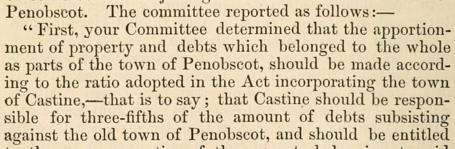
Penobscot. The committee reported as follows : — " First, your Committee determined that the apportionment of property and debts which belonged to the whole as parts of the town of Penobscot, should be made according to the ratio adopted in the Act incorporating the town of Castine, — that is to say ; that Castine should be responsible for three-fifths of the amount of debts subsisting against the old town of Penobscot, and should be entitled
Text read by machine from the scan; it may contain errors.
History of Penobscot County, Maine1882 · page 668Read the page →
Read the text
of the Kenduskeag Bank. Bangor; to incorporate Bangor Savings Institution; to incorporate the Bangor and Piscataquis Railroad Company; additional act to incorporate Commercial Bank, Bangor; to incorporate Penobscot Stage Company; to incorporate Bangor & Pushaw Canal Company; to incorporate Bangor Insurance Company; to incorporate Penobscot Log Driving Company; to incorporate Bangor House Proprietary; additional act to
Text read by machine from the scan; it may contain errors.
History of Castine, Penobscot, and Brooksville, Maine1875 · page 120Read the page →
Read the text
The Second Parish had no settled minister while it was a part of [the town of Penobscot, though Mr, Powers, Mr. Abbott, and some itinerant preachere oflBciated there a portion of the time. By the tenns of settlement agreed upon by the joint committee of the two towns of Penobscot and Castine, the meeting-house on the peninsula became the property of the latter town, and was thereafter known as the meeting-honse of the First Parish of Castine.
Text read by machine from the scan; it may contain errors.
History of Penobscot County, Maine1882 · page 165Read the page →
Read the text
No report of transactions or fair was made by the Penobscot Society in 1854, and the ne.xt year it seems to have split up into several societies, since mention is made, in the State Agricultural Report of 1855, of the West Penobscot, the North Penobscot, and the Penobscot and .Aroostook Union Societies, while of the older Penobscot County Society it is said: "Show and Fair omitted this year," from which it may be inferred
Text read by machine from the scan; it may contain errors.
Scans and text from the Internet Archive. Books published in 1930 or earlier, which are in the public domain.
Timeline
Penobscot, 1787 to 1966
Woven from the archive, old maps, post office records, the National Register and the people born here.
Nothing in the archives for these yearsWeddings on Main Street, storms, parades, school pictures, the old store. If it’s in your family album, it belongs here.
In 1787, according to Wikidata. Penobscot’s post office opened in 1836, and the first U.S. census counted 1,048 people here in 1790.
How does Penobscot rank for history?
Penobscot is more historic than 65% of U.S. towns. The History grade combines the town’s founding era, the share of homes built before 1940 and its National Register listings. It’s a character grade, so it isn’t part of the overall grade. How it works.
How old are the homes in Penobscot?
29% of Penobscot’s homes were built before 1940 (Census estimate, ±8.3 points), against a typical 19% for a Maine town; the median home was built in 1979.
Founding dates: Wikidata, Wikipedia, the U.S. post office records of Blevins & Helbock (CC0) and the Census. Homes by year built: Census ACS 2020–24. National Register of Historic Places: National Park Service (list of May 22, 2026). Old photos, postcards and papers: Wikimedia Commons, the Library of Congress and other public archives, credited on each item’s page. Maps: U.S. Geological Survey historical topographic maps (via Esri) and Sanborn fire-insurance maps (Library of Congress). History text and census tables: Wikipedia (CC BY-SA 4.0). Places that used to be: USGS Geographic Names Information System (2021).
From Wikimedia Commons (6), Wikidata and Wikipedia for famous people, U.S. Geological Survey historical maps, U.S. Census counts (via Wikipedia), the US Post Offices dataset (Blevins & Helbock), the USGS Geographic Names Information System and old county and town histories (Internet Archive). Archive images are copied here with their credits and licenses, shown on each photo’s page. Refreshed monthly.






 1787
 Date?
 2014
