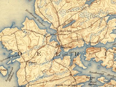
6 places in town are on the National Register, among them two historic districts with 36 buildings between them. Below: 6 old photos and papers, maps from 1904 on, and the census since 1790.
Founding year: Wikidata; Wikipedia’s history section gives the same year. First post office: 1820.The full story ↓
History grade
What drives Deer Isle’s History grade
On its age, its old homes and the National Register, Deer Isle is more historic than 95% of U.S. towns. All 3 inputs are above most U.S. towns; its National Register listings ranks highest and its age lowest.
A
HistoryA character grade: shown, never part of Deer Isle’s overall grade.
Maine towns list more on the Register than most of the country (a typical Maine town has 15.9 per 10,000 residents, the U.S. 2.4), so Deer Isle’s 166 sits above most of its state (93% of Maine towns have fewer) while its 41 historic buildings outnumber those of 84% of U.S. towns.
How sure. Graded on any two of the three inputs instead, the letter would still be A. The pre-1940 share is a Census survey estimate (±6.5 points). Two sources give 1789.
Founding year: Wikidata (other dates in Quick answers). Homes: Census ACS 2020–24. National Register: National Park Service, May 2026 list; each listing counted once (boundary changes and added documentation belong to their listing), and a historic district counts its contributing buildings. How TownRatings grades history →
What stands out about Deer Isle’s past
Read from the archive, the National Register and the record. The page puts what stands out first.
The town was incorporated in 1789, at which time it included the islands of Little Deer Isle, Deer Isle, and Isle au Haut. Deer were abundant on these islands, hence the name. In 1868 Isle au Haut became a separate town. In 1897, the southern third of Deer Isle incorporated as the town of Stonington.
In the 19th century, the granite industry flourished on Deer Isle, where its quarries supplied granite for structures such as the Boston Museum of Fine Arts, the Smithsonian Institution, the US Naval Academy, the Manhattan Bridge, and President John F. Kennedy's tomb at Arlington National Cemetery.
Passages that mention Deer Isle, cut from the printed page as they were published.
An historical sketch of the town of Deer Isle, Maine1905 · page 204Read the page →
Read the text
more abundant there than now and could be taken nearer the shores. With them agriculture was not a consideration; had it been, it would never have been settled. The town of Deer Isle contains a large proportion of land that can never be cultivated, especially in the southern part ; and most of the early settlers, in that part of the town, depended upon fishing. It has been their chief employment for a large part of the time since, and in past years
Text read by machine from the scan; it may contain errors.
An historical sketch of the town of Deer Isle, Maine, with notices of its settlers and early inhabitants1886 · page 212Read the page →
Read the text
The town of Deer Isle contains a large proportion of land that can never be cultivated, especially in the southern part ; and most of the early settlers depended upon fishing,
Text read by machine from the scan; it may contain errors.
An historical sketch of the town of Deer Isle, Maine, with notices of its settlers and early inhabitants1886 · page 211Read the page →
Read the text
We have now given a sketch of the settlement of the towns of Deer Isle and Isle au Haut, and noticed the earlier settlers and those of a later date, with such incidents as we have judged worth the notices that have been given them. With the exception of that which has been written respecting the discovery, and from the information gained from a list of the settlers prior to 1784, found among the proprietors' papers which were in the custody
Text read by machine from the scan; it may contain errors.
An historical sketch of the town of Deer Isle, Maine1905 · page 202Read the page →
Read the text
I HAVE now given a sketch of the settlement of the towns of Deer Isle and Isle au Haut, of the earliest settlers, and of those of a later date. It has been written entirely from memory, with the exception of that which relates to the probable discoverers, and of the information that was gained from a list of those who were here prior to 1784, found among the papers of the " Proprietors," which were in the custody of the late Solomon Haskell, Esq., and
Text read by machine from the scan; it may contain errors.
Scans and text from the Internet Archive. Books published in 1930 or earlier, which are in the public domain.
Timeline
Deer Isle, 1785 to 1950
Woven from the archive, old maps, post office records, the National Register and the people born here.
Nothing in the archives for these yearsWeddings on Main Street, storms, parades, school pictures, the old store. If it’s in your family album, it belongs here.
In 1789, according to Wikidata and Wikipedia’s history of the town. Deer Isle’s post office opened in 1820, and the first U.S. census counted 682 people here in 1790.
How does Deer Isle rank for history?
Deer Isle is more historic than 95% of U.S. towns. The History grade combines the town’s founding era, the share of homes built before 1940 and its National Register listings. It’s a character grade, so it isn’t part of the overall grade. How it works.
What is on the National Register in Deer Isle?
6 listings: 4 buildings, among them the Olmsted, Frederick Law, Summer Home (listed 1976, the first), and 2 historic districts, the Pumpkin Island Light Station and the Haystack Mountain School of Crafts, with 36 contributing buildings. 41 historic buildings in all.
How old are the homes in Deer Isle?
31% of Deer Isle’s homes were built before 1940 (Census estimate, ±6.5 points), against a typical 19% for a Maine town; the median home was built in 1976.
Founding dates: Wikidata, Wikipedia, the U.S. post office records of Blevins & Helbock (CC0) and the Census. Homes by year built: Census ACS 2020–24. National Register of Historic Places: National Park Service (list of May 22, 2026). Old photos, postcards and papers: Wikimedia Commons, the Library of Congress and other public archives, credited on each item’s page. Maps: U.S. Geological Survey historical topographic maps (via Esri) and Sanborn fire-insurance maps (Library of Congress). History text and census tables: Wikipedia (CC BY-SA 4.0). Places that used to be: USGS Geographic Names Information System (2021).
From Wikimedia Commons (5), the Library of Congress (1), Wikidata (1), the National Register of Historic Places (6), Wikipedia, Wikidata and Wikipedia for famous people, U.S. Geological Survey historical maps, U.S. Census counts (via Wikipedia), the US Post Offices dataset (Blevins & Helbock), the USGS Geographic Names Information System and old county and town histories (Internet Archive). Archive images are copied here with their credits and licenses, shown on each photo’s page. Refreshed monthly.




 1884
 c. 1930
 c. 1930


