Cumberland’s post office opened in 1824, and 15% of its homes were built before 1940
More historic than 65% of U.S. towns · #107 of 143 in Maine. What drives it
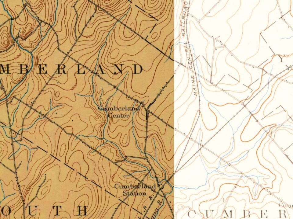
Its Register listings are the Winn Road School and the Capt. Reuel and Lucy Merrill House. Its Register listings are the Winn Road School and the Capt. Reuel and Lucy Merrill House. Below: 5 old photos and papers, maps from 1894 on, and the census since 1830.
The Cumberland post office opened in 1824, the earliest record of the town by name. Another post office, West Cumberland (1846), opened inside today’s town and later closed.
First census: 1,558 in 18302020 census: 8,473202 years
How historic is Cumberland?
B
More historic than 65% of U.S. towns, on its age, its old homes and the National Register.
Founding year: the first Cumberland post office (Blevins & Helbock, CC0).The full story ↓
History grade
What drives Cumberland’s History grade
On its age, its old homes and the National Register, Cumberland is more historic than 65% of U.S. towns, #107 of 143 in Maine. Its age holds the grade up; its National Register listings pull it down.
B
HistoryA character grade: shown, never part of Cumberland’s overall grade.
Maine towns list more on the Register than most of the country (a typical Maine town has 15.9 per 10,000 residents, the U.S. 2.4), so Cumberland’s 2.3 sits below most of its state (20% of Maine towns have fewer) while its 2 listings outnumber those of 60% of U.S. towns.
How sure. Graded on any two of the three inputs instead, the letter would range from B− to B+. The pre-1940 share is a Census survey estimate (±4.6 points). The founding year is the first post office, not a stated founding date.
Founding year: the first post office (other dates in Quick answers). Homes: Census ACS 2020–24. National Register: National Park Service, May 2026 list; each listing counted once (boundary changes and added documentation belong to their listing), and a historic district counts its contributing buildings. How TownRatings grades history →
What stands out about Cumberland’s past
Read from the archive, the National Register and the record. The page puts what stands out first.
Cumberland, Maine (also known as Cumberland Center), became independent in March 1821 after it split from North Yarmouth. The town was officially named by Ephraim Sturdivant when the new town government elected him to do the task.
The Cumberland Fair, an annual agricultural fair, has been held yearly in Cumberland during the month of September since 1868. This Portland suburb has a rich farming history, but only a small number of working farms remain, such as Sweetser's Apple Barrel & Orchards, Spring Brook Farms, and Double T Orchards. Chebeague Island, long a part of Cumberland, formed its own town in 2007. Since 1960, Cumberland's motto has been "Where what comes around keeps going around!"
Passages that mention Cumberland, cut from the printed page as they were published.
History of Cumberland Co., Maine1880 · page 264Read the page →
Read the text
The town of Cumberland was incorporated by an act of the Legislature of Maine, dividing the town of North Yarmouth, passed March 19th and approved March 28, 1821.
Text read by machine from the scan; it may contain errors.
History of Cumberland Co., Maine1880 · page 81Read the page →
Read the text
repaired and remodeled inside, giving much-improved passenger accommodations. By consent of President Anderson, of the Portland and Ogdensburg Railroad, the station building at Cumberland Mills, owned by that company, has been moved to the junction of the tracks, and the south end finished into a waiting-room for passengers, the north end being used for fi-eight purposes. Hereafter the station will be occupied jointly by the two roads.
Text read by machine from the scan; it may contain errors.
Scans and text from the Internet Archive. Books published in 1930 or earlier, which are in the public domain.
Timeline
Cumberland, 1797 to 2020
Woven from the archive, old maps, post office records, the National Register and the people born here.
The Cumberland post office opened in 1824, the earliest record of the town by name (U.S. post office records).
How does Cumberland rank for history?
Cumberland is more historic than 65% of U.S. towns, #107 of 143 in Maine. The History grade combines the town’s founding era, the share of homes built before 1940 and its National Register listings. It’s a character grade, so it isn’t part of the overall grade. How it works.
What is on the National Register in Cumberland?
Two places: the Winn Road School (listed 1984) and the Capt. Reuel and Lucy Merrill House (1999).
How old are the homes in Cumberland?
15% of Cumberland’s homes were built before 1940 (Census estimate, ±4.6 points), against a typical 19% for a Maine town; the median home was built in 1984.
Founding dates: Wikidata, Wikipedia, the U.S. post office records of Blevins & Helbock (CC0) and the Census. Homes by year built: Census ACS 2020–24. National Register of Historic Places: National Park Service (list of May 22, 2026). Old photos, postcards and papers: Wikimedia Commons, the Library of Congress and other public archives, credited on each item’s page. Maps: U.S. Geological Survey historical topographic maps (via Esri) and Sanborn fire-insurance maps (Library of Congress). History text and census tables: Wikipedia (CC BY-SA 4.0). Places that used to be: USGS Geographic Names Information System (2021).
From Wikimedia Commons (19), the Library of Congress (1), Wikidata (2), the National Register of Historic Places (2), Wikipedia, Wikidata and Wikipedia for famous people, U.S. Geological Survey historical maps, U.S. Census counts (via Wikipedia), the US Post Offices dataset (Blevins & Helbock), the USGS Geographic Names Information System and old county and town histories (Internet Archive). Archive images are copied here with their credits and licenses, shown on each photo’s page. Refreshed monthly.




 Date?
 Date?
 Date?
 Date?
 Date?
 2025
 2024
 2024
 2023
 2023
 2019
 2019
 2019
 2019
 2019
 2018
 2018
 2017
 2013
 2008

