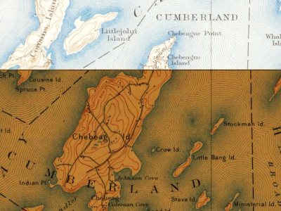
Every edition of the U.S. Geological Survey’s map of Chebeague Island. Tap a year, or press play to watch the town change.
1893Casco Bay sheet · 1:62,500
U.S. Geological Survey historical topographic maps (public domain), via Esri’s collection of the scans. The red ring marks the center of Chebeague Island.
The name "Chebeague" evolved from Chebiscodego, the name used by members of the Wabanaki Confederacy, a First Nations and Native American confederation of five principal nations: the Mi'kmaq, Maliseet, Passamaquoddy, Abenaki, and Penobscot. Historians have cited one possible definition of the word Chebeague as "island of many springs." Other sources state that Chebeague comes from the Abenaki words T’Cabie or Chebidisco, meaning cold spring, or Jabeque or Gaboag, meaning separated, which recognizes the connectedness of Great Chebeague and Little Chebeague islands. Great Chebeague Island was also known for stretches as Indian Isle, Merry's Island and Recompense Island.
Founding dates: Wikidata, Wikipedia, the U.S. post office records of Blevins & Helbock (CC0) and the Census. Homes by year built: Census ACS 2020–24. National Register of Historic Places: National Park Service (list of May 22, 2026). Old photos, postcards and papers: Wikimedia Commons, the Library of Congress and other public archives, credited on each item’s page. Maps: U.S. Geological Survey historical topographic maps (via Esri) and Sanborn fire-insurance maps (Library of Congress). History text and census tables: Wikipedia (CC BY-SA 4.0). Places that used to be: USGS Geographic Names Information System (2021). How TownRatings grades history →
From the National Register of Historic Places (2), Wikipedia, U.S. Geological Survey historical maps, the US Post Offices dataset (Blevins & Helbock) and the USGS Geographic Names Information System. Archive images are copied here with their credits and licenses, shown on each photo’s page. Refreshed monthly.