Chelsea dates to 1851, and 16% of its homes were built before 1940
More historic than 71% of U.S. towns · #97 of 143 in Maine. What drives it
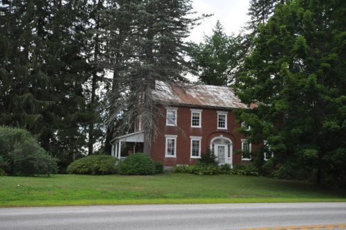
3 places in town are on the National Register, among them the Governor's House, a National Historic Landmark, and a historic district with 49 buildings. Below: maps from 1948 on and the census since 1860.
Founding year: Wikipedia. First post office: 1879.The full story ↓
History grade
What drives Chelsea’s History grade
On its age, its old homes and the National Register, Chelsea is more historic than 71% of U.S. towns, #97 of 143 in Maine. Its National Register listings hold the grade up; its age pulls it down.
B+
HistoryA character grade: shown, never part of Chelsea’s overall grade.
Maine towns list more on the Register than most of the country (a typical Maine town has 15.9 per 10,000 residents, the U.S. 2.4), so Chelsea’s 181 sits above most of its state (93% of Maine towns have fewer) while its 51 historic buildings outnumber those of 85% of U.S. towns.
NoteThe founding year comes from Wikipedia alone; no second source gives 1851.
How sure. Graded on any two of the three inputs instead, the letter would range from C+ to A−. The pre-1940 share is a Census survey estimate (±7.6 points).
Founding year: Wikipedia (other dates in Quick answers). Homes: Census ACS 2020–24. National Register: National Park Service, May 2026 list; each listing counted once (boundary changes and added documentation belong to their listing), and a historic district counts its contributing buildings. How TownRatings grades history →
What stands out about Chelsea’s past
Read from the archive, the National Register and the record. The page puts what stands out first.
Chelsea was incorporated as a town on March 1, 1851, separating from a portion of Hallowell. The town was named after the town of Chelsea, Massachusetts.
Passages that mention Chelsea, cut from the printed page as they were published.
Illustrated history of Kennebec County, Maine1892 · page 749Read the page →
Read the text
THE town of Chelsea was incorporated Augu.st 17, 1850, from the southern portion of the old town of Hallowell, on the eastern bank of the Kennebec river. It embraces the lots of the Winslow survey shown on the sketch map on page 750, together with additional territory extending eastward to the town of Whitefield. The city of Augusta bounds it on the north and the towns of Randolph and Pittston bound it on the south. Though this tract of land was settled contemporaneously with the earliest settled territory along the
Text read by machine from the scan; it may contain errors.
Illustrated history of Kennebec County, Maine1892 · page 398Read the page →
Read the text
The lines of these parishes are substantially intact to-day. The South .parish was the territory of modern Hallowell, before it was deprived of Chelsea and parts of Manchester and Farmingdale. When ancient (Hallowell was divided, the two other parishes remained intact, but from a geographical necessity the name of the original Middle parish was changed to South — the present South parish of Augusta. The term " ^'/a' South parish " properly applies to Hallowell and not to the newer one of Augusta.* A meeting house that is still standing was
Text read by machine from the scan; it may contain errors.
Scans and text from the Internet Archive. Books published in 1930 or earlier, which are in the public domain.
Timeline
Chelsea, 1815 to 1974
Woven from the archive, old maps, post office records, the National Register and the people born here.
In 1851, according to Wikipedia’s history of the town. Chelsea’s post office opened in 1879, and the census of 1860 counted 1,024 people here.
How does Chelsea rank for history?
Chelsea is more historic than 71% of U.S. towns, #97 of 143 in Maine. The History grade combines the town’s founding era, the share of homes built before 1940 and its National Register listings. It’s a character grade, so it isn’t part of the overall grade. How it works.
What is on the National Register in Chelsea?
Three places: the Governor's House (listed 1974), the John Davis House (1983) and the Togus VA Medical Center and National Cemetery (2012).
How old are the homes in Chelsea?
16% of Chelsea’s homes were built before 1940 (Census estimate, ±7.6 points), against a typical 19% for a Maine town; the median home was built in 1982.
Founding dates: Wikidata, Wikipedia, the U.S. post office records of Blevins & Helbock (CC0) and the Census. Homes by year built: Census ACS 2020–24. National Register of Historic Places: National Park Service (list of May 22, 2026). Old photos, postcards and papers: Wikimedia Commons, the Library of Congress and other public archives, credited on each item’s page. Maps: U.S. Geological Survey historical topographic maps (via Esri) and Sanborn fire-insurance maps (Library of Congress). History text and census tables: Wikipedia (CC BY-SA 4.0). Places that used to be: USGS Geographic Names Information System (2021).
From Wikimedia Commons (1), Wikidata (2), the National Register of Historic Places (3), Wikipedia, Wikidata and Wikipedia for famous people, U.S. Geological Survey historical maps, U.S. Census counts (via Wikipedia), the US Post Offices dataset (Blevins & Helbock), the USGS Geographic Names Information System and old county and town histories (Internet Archive). Archive images are copied here with their credits and licenses, shown on each photo’s page. Refreshed monthly.


 ★ Landmark


 2018


