Augusta dates to 1628, and 29% of its homes were built before 1940
Among the most historic 1% of U.S. towns · #7 of 143 in Maine. What drives it
41 places in town are on the National Register, among them 3 National Historic Landmarks and seven historic districts with 265 buildings between them. Below: 12 old photos and papers, maps from 1884 on, and the census since 1800.
Founding year: Wikidata. First post office: 1797.The full story ↓
History grade
What drives Augusta’s History grade
On its age, its old homes and the National Register, Augusta is among the most historic 1% of U.S. towns, #7 of 143 in Maine. All 3 inputs are above most U.S. towns; its age ranks highest and its share of homes from before 1940 lowest.
A+
HistoryA character grade: shown, never part of Augusta’s overall grade.
Maine towns list more on the Register than most of the country (a typical Maine town has 15.9 per 10,000 residents, the U.S. 2.4), so Augusta’s 158 sits above most of its state (91% of Maine towns have fewer) while its 301 historic buildings outnumber those of 95% of U.S. towns.
NoteThe founding year comes from Wikidata alone; no second source gives 1628.
How sure. Graded on any two of the three inputs instead, the letter would still be A+. The pre-1940 share is a Census survey estimate (±4.7 points).
Founding year: Wikidata (other dates in Quick answers). Homes: Census ACS 2020–24. National Register: National Park Service, May 2026 list; each listing counted once (boundary changes and added documentation belong to their listing), and a historic district counts its contributing buildings. How TownRatings grades history →
What stands out about Augusta’s past
Read from the archive, the National Register and the record. The page puts what stands out first.
The country’s official list of buildings and places worth saving. 3 are National Historic Landmarks, the highest tier. Boundary changes and added documentation are counted with their listing.
The area was first explored by the English of the short-lived Popham Colony in September 1607. Twenty-one years later, English settlers from the Plymouth Colony settled in the area in 1628 as part of a trading post on the Kennebec River. The settlement was known by its Native American name Cushnoc (or Coussinoc or Koussinoc), meaning "head of the tide". Fur trading was at first profitable, but because of Native uprisings and declining revenues, Plymouth Colony sold the Kennebec Patent in 1661. Cushnoc would remain unoccupied for the next 75 years.
The area around Cushnoc was inhabited by the Kennebec, a band of the larger Abenaki nation. During the 17th century, they were on friendly terms with the English settlers in the region.
Passages that mention Augusta, cut from the printed page as they were published.
Illustrated history of Kennebec County, Maine1892 · page 398Read the page →
Read the text
of Chelsea and parts of Manchester and Farmingdale. When ancient (Hallowell was divided, the two other parishes remained intact, but from a geographical necessity the name of the original Middle parish was changed to South — the present South parish of Augusta. The term " ^'/a' South parish " properly applies to Hallowell and not to the newer one of Augusta.* A meeting house that is still standing was built in the North parish in 1832.
Text read by machine from the scan; it may contain errors.
Illustrated history of Kennebec County, Maine1892Read the page →
Read the text
his selections always seemed to fill a popular demand. He was held in high esteem, and regarded as a public benefactor. He gave employment to a large number of persons and was interested in man^ enterprises. To his publishing establishment the Augusta post office owes its rank as a "first-class" post office, and the city of Augusta is indebted for its beautiful granite post office building, to the fact that his enormous transactions through the mails rendered it necessary.* *He had sixteen large presses, manufactured for his business, in constant
Text read by machine from the scan; it may contain errors.
Scans and text from the Internet Archive. Books published in 1930 or earlier, which are in the public domain.
By decade
Augusta, decade by decade
2 decades in the archive, from the 1850s to the 1860s. Scroll each row; tap a photo for its story.
Every edition of the U.S. Geological Survey’s map of Augusta. Tap a year, or press play to watch the town change.
1892Augusta sheet · 1:62,500
U.S. Geological Survey historical topographic maps (public domain), via Esri’s collection of the scans. The red ring marks the center of Augusta.
Every building
Augusta, building by building, 1884–1918
Fire insurance maps drew every building, what it was made of and what it was used for, so insurers could price the risk of fire. Pick a year, then a sheet.
Ballard SchoolschoolEdwards DamdamElla R Hodgkins SchoolschoolStone Schoolschool
24cemeteries and burying grounds inside Augusta
Ben VenueBolton HillBrackettConyCoombsCottlesCummingsForest GroveHoly FamilyKlingMaine Veterans Memorial Cemetery - Civic Center DriveMount HopeMount PleasantMount Pleasant Cemetery Soldiers' LotMount VernonMud MillRiversideSaint AugustineSaint MarysState of MaineTownsendWadeWallWilliams
See all 24
Ben Venue Cemetery · Bolton Hill Cemetery · Brackett Cemetery · Cony Cemetery · Coombs Cemetery · Cottles Cemetery · Cummings Cemetery · Forest Grove Cemetery · Holy Family Cemetery · Kling Cemetery · Maine Veterans Memorial Cemetery - Civic Center Drive · Mount Hope Cemetery · Mount Pleasant Cemetery · Mount Pleasant Cemetery Soldiers' Lot · Mount Vernon Cemetery · Mud Mill Cemetery · Riverside Cemetery · Saint Augustine Cemetery · Saint Marys Cemetery · State of Maine Burial Ground · Townsend Cemetery · Wade Cemetery · Wall Cemetery · Williams Cemetery
US Post Offices dataset (Blevins & Helbock, CC0). Places and cemeteries from the USGS Geographic Names Information System (2021).
Help out
Finish Augusta’s story
Most archives stop around 1920. The photos from after that are in family albums, not libraries.
Decades since 1900 with photos
00s10s20s30s40s50s60s70s80s90s
0 of 10 decades. The empty ones are waiting for someone’s album.
In 1628, according to Wikidata. Augusta’s post office opened in 1797, and the census of 1800 counted 1,211 people here.
How does Augusta rank for history?
Augusta is among the most historic 1% of U.S. towns, #7 of 143 in Maine. The History grade combines the town’s founding era, the share of homes built before 1940 and its National Register listings. It’s a character grade, so it isn’t part of the overall grade. How it works.
What is on the National Register in Augusta?
41 listings, 3 of them National Historic Landmarks: 33 buildings, among them the James G. Blaine House (a National Historic Landmark since 1964), 7 historic districts with 265 contributing buildings, and 1 site. 301 historic buildings in all.
How old are the homes in Augusta?
29% of Augusta’s homes were built before 1940 (Census estimate, ±4.7 points), against a typical 19% for a Maine town; the median home was built in 1965.
Founding dates: Wikidata, Wikipedia, the U.S. post office records of Blevins & Helbock (CC0) and the Census. Homes by year built: Census ACS 2020–24. National Register of Historic Places: National Park Service (list of May 22, 2026). Old photos, postcards and papers: Wikimedia Commons, the Library of Congress and other public archives, credited on each item’s page. Maps: U.S. Geological Survey historical topographic maps (via Esri) and Sanborn fire-insurance maps (Library of Congress). History text and census tables: Wikipedia (CC BY-SA 4.0). Places that used to be: USGS Geographic Names Information System (2021).
From Wikimedia Commons (12), Wikidata (9), the National Register of Historic Places (41), Wikipedia, Wikidata and Wikipedia for famous people, U.S. Geological Survey historical maps, U.S. Census counts (via Wikipedia), the US Post Offices dataset (Blevins & Helbock), the USGS Geographic Names Information System, Sanborn fire insurance maps (Library of Congress) and old county and town histories (Internet Archive). Archive images are copied here with their credits and licenses, shown on each photo’s page. Refreshed monthly.
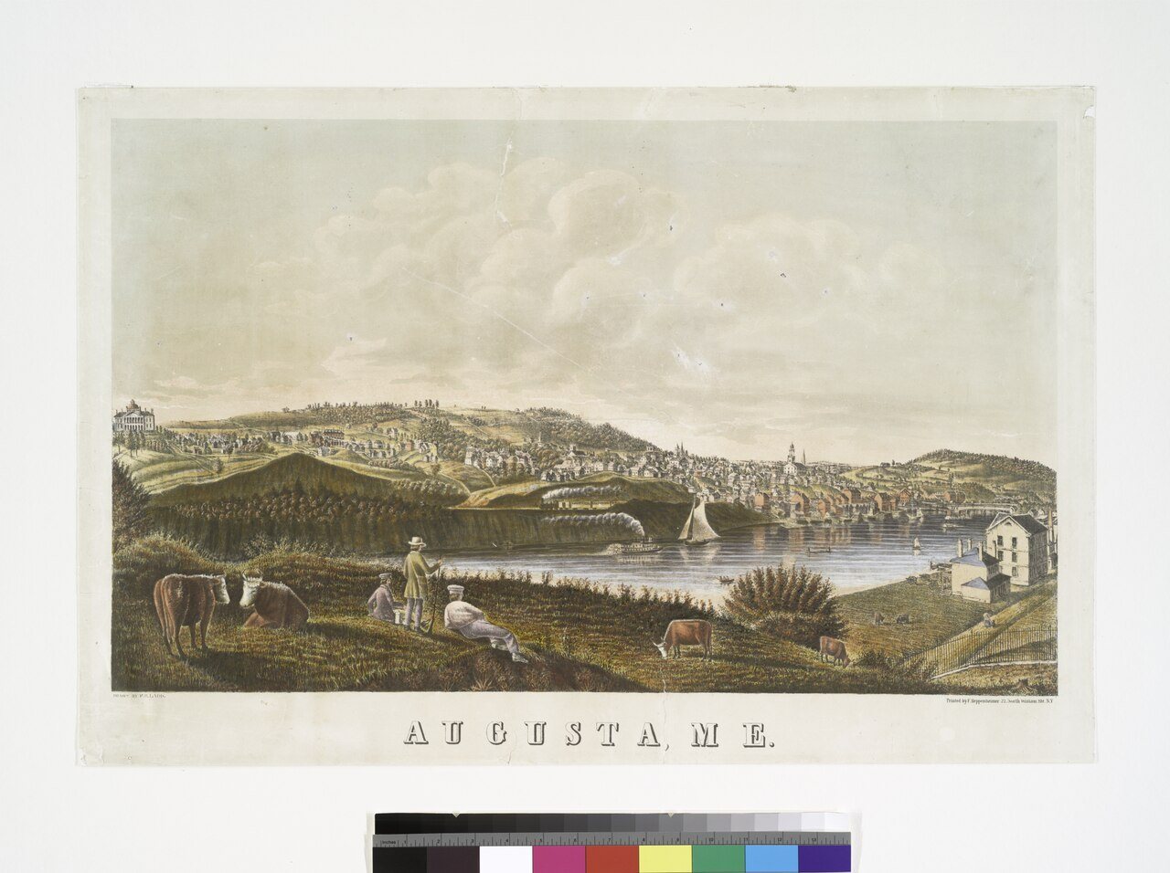


 ★ Landmark
 ★ Landmark
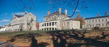 ★ Landmark




 c. 1869
 c. 1869
 c. 1869
 c. 1869
 c. 1869
 c. 1869
 c. 1869
 c. 1869
 c. 1869
 c. 1869


