9 places in town are on the National Register, among them two historic districts with 5 buildings between them. Below: 2 old photos and papers from 1900 on and old-book passages.
Founding year: Wikidata. First post office: 1797.The full story ↓
History grade
What drives Truro’s History grade
On its age, its old homes and the National Register, Truro is more historic than 85% of U.S. towns. All 3 inputs are above most U.S. towns; its age ranks highest and its share of homes from before 1940 lowest.
A−
HistoryA character grade: shown, never part of Truro’s overall grade.
Massachusetts towns list more on the Register than most of the country (a typical Massachusetts town has 46.0 per 10,000 residents, the U.S. 2.4), so Truro’s 52.7 sits near the middle of its state (51% of Massachusetts towns have fewer) while its 9 listings outnumber those of 75% of U.S. towns.
NoteThe founding year comes from Wikidata alone; no second source gives 1700.
How sure. Graded on any two of the three inputs instead, the letter would range from B+ to A. The pre-1940 share is a Census survey estimate (±4.2 points).
Founding year: Wikidata (other dates in Quick answers). Homes: Census ACS 2020–24. National Register: National Park Service, May 2026 list; each listing counted once (boundary changes and added documentation belong to their listing), and a historic district counts its contributing buildings. How TownRatings grades history →
What stands out about Truro’s past
Read from the archive, the National Register and the record. The page puts what stands out first.
Lost post offices, old corners, places now gone and burying grounds
Truro’s post office has been open since 1797. Another post office, South Truro, opened and closed inside today’s town.
Truro
1797–today
North Truro
1830–today
South Truro
1874–1933
17901910today
Hamlets and corners on the map
Beach PointNorth TruroPilgrim HeightsPond VillageSouth TruroTruro Station
Gone or out of use
High Head United States Life Saving StationlocaleHighland United States Life Saving StationlocaleNorth Truro StationbuildingPamet River United States Life Saving Stationlocale
4cemeteries and burying grounds inside Truro
Hill of Churches Hills of StormsOld NorthPine GroveSnow
US Post Offices dataset (Blevins & Helbock, CC0). Places and cemeteries from the USGS Geographic Names Information System (2021).
Cape Cod was the territory of successive cultures of indigenous peoples for thousands of years before Europeans arrived. At the time of English colonization, the Wampanoag tribe was the dominant one on Cape Cod, numbering about 7,000 by early accounts. They used the cape and its waters for hunting, fishing and gathering shellfish. They also cultivated maize to supplement their diets and to store for winter eating.
Passages that mention Truro, cut from the printed page as they were published.
History of Barnstable County, Massachusetts, 1620-1637-1686-18901890 · page 964Read the page →
Read the text
along the western fence of the present Eastern school house, touching the eastern side of Grassy pond as it ran across the Cape to the Atlantic. ^ The union of the precinct of Cape Cod with Truro was not satisfactory to the inhabitants of Truro, who found the anomalous municipal charter of the precinct a source of many difficulties in administration. Accordingly in 1715 a petition from the in habitants of Truro was presented to the general court by Constant Freeman, the Repre-
Text read by machine from the scan; it may contain errors.
In 1855, leave having been obtained to construct a bridge from this town to Beach Point in Truro, an appropriation was made for that object. The bridge was built at a cost of about $9,000, of which this town paid about one half and the town of Truro and the county the balance* *Mr. Silas Atkins had, by wife Bethia, Isaiah Oct 16, 1786; Betiua Fob. 20, 1789 ; Martha June 5, 1793 ; and Joshua Mar. 16, 1795. Joseph had, by wifo Ruth, Joseph Juno 28, 1789; Freeman Oct 8, 1790 ; and Ruth
Text read by machine from the scan; it may contain errors.
History of Barnstable County, Massachusetts, 1620-1637-1686-18901890 · page 970Read the page →
Read the text
At a meeting of the proprietors of Truro April 26, 1716, a vote was passed to apply to the court of quarter sessions for the County of Barnstable for a highway to be laid out from Eastham to Truro and through Truro down to and through the province lands upon Cape Cod. It is not probable, however, that at this early date any attempt was made to lay out a definite highway across the sand banks to the north of Eastern Harbor meadows from Truro to Provincetown, along which for many years travelers between the two towns were forced
Text read by machine from the scan; it may contain errors.
a That agreement was as follows : " Whereas the Inhabitants of the Town of Truro did, at a meeting of said town convened and held at Truro, Feb. 23, 1710-11, by unanimous vote, call and invite Mr. John Avery to a settlement in the work of the Gospel ministry among them ; and for his support and encouragement in said work, did offer him £60 a year salary and £20 toward his building when he shall sec cause to build him a dwelling-house in said town, and sent by a Committee to inform the said Mr. John Avery of their desire and offer in that matter, as by a record of said town, bearing
Text read by machine from the scan; it may contain errors.
Scans and text from the Internet Archive. Books published in 1930 or earlier, which are in the public domain.
By decade
Truro, decade by decade
One decade in the archive so far: the 1900s. Scroll each row; tap a photo for its story.
Nothing in the archives for these yearsWeddings on Main Street, storms, parades, school pictures, the old store. If it’s in your family album, it belongs here.
In 1700, according to Wikidata. Truro’s post office opened in 1797.
How does Truro rank for history?
Truro is more historic than 85% of U.S. towns. The History grade combines the town’s founding era, the share of homes built before 1940 and its National Register listings. It’s a character grade, so it isn’t part of the overall grade. How it works.
What is on the National Register in Truro?
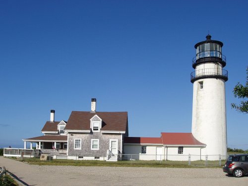
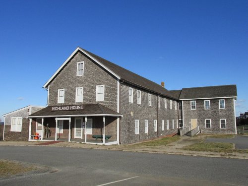
9 listings: 3 buildings, among them the Highland House (listed 1975, the first), 2 historic districts, the Truro Highlands Historic District and the First Congregational Parish Historic District, with 5 contributing buildings, 2 sites, and 2 structures.
How old are the homes in Truro?
14% of Truro’s homes were built before 1940 (Census estimate, ±4.2 points), against a typical 21% for a Massachusetts town; the median home was built in 1980.
Founding dates: Wikidata, Wikipedia, the U.S. post office records of Blevins & Helbock (CC0) and the Census. Homes by year built: Census ACS 2020–24. National Register of Historic Places: National Park Service (list of May 22, 2026). Old photos, postcards and papers: Wikimedia Commons, the Library of Congress and other public archives, credited on each item’s page. Maps: U.S. Geological Survey historical topographic maps (via Esri) and Sanborn fire-insurance maps (Library of Congress). History text and census tables: Wikipedia (CC BY-SA 4.0). Places that used to be: USGS Geographic Names Information System (2021).
From Wikimedia Commons (2), Wikidata (4), the National Register of Historic Places (9), Wikipedia, Wikidata and Wikipedia for famous people, the US Post Offices dataset (Blevins & Helbock), the USGS Geographic Names Information System and old county and town histories (Internet Archive). Archive images are copied here with their credits and licenses, shown on each photo’s page. Refreshed monthly.






 c. 1901


