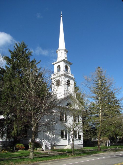
Kingston dates to 1620, and 14% of its homes were built before 1940
More historic than 83% of U.S. towns · #207 of 283 in Massachusetts. What drives it
4 places in town are on the National Register, among them a historic district with 23 buildings. Below: 4 old photos and papers, maps from 1886 on, and the census since 1790.
Founding year: Wikidata. First post office: 1800.The full story ↓
History grade
What drives Kingston’s History grade
On its age, its old homes and the National Register, Kingston is more historic than 83% of U.S. towns, #207 of 283 in Massachusetts. All 3 inputs are above most U.S. towns; its age ranks highest and its share of homes from before 1940 lowest.
A−
HistoryA character grade: shown, never part of Kingston’s overall grade.
Massachusetts towns list more on the Register than most of the country (a typical Massachusetts town has 46.0 per 10,000 residents, the U.S. 2.4), so Kingston’s 20.0 sits near the middle of its state (36% of Massachusetts towns have fewer) while its 28 historic buildings outnumber those of 81% of U.S. towns.
How sure. Graded on any two of the three inputs instead, the letter would range from B to A−. The pre-1940 share is a Census survey estimate (±4.3 points). Two sources give 1620.
Founding year: Wikidata (other dates in Quick answers). Homes: Census ACS 2020–24. National Register: National Park Service, May 2026 list; each listing counted once (boundary changes and added documentation belong to their listing), and a historic district counts its contributing buildings. How TownRatings grades history →
What stands out about Kingston’s past
Read from the archive, the National Register and the record. The page puts what stands out first.
Before European settlers arrived, Kingston was within the tribal homeland of the Wampanoag people. Several years before the Mayflower had landed in Plymouth, during the Native American epidemic of 1616 to 1619, the Wampanoag population was severely damaged from a rapidly spreading pandemics due to earlier contacts with Europeans. Several ancient Native American burial sites have been located within the borders of Kingston.
Passages that mention Kingston, cut from the printed page as they were published.
History of the early settlement of Bridgewater in Plymouth county, Massachusetts, including an extensive Family register1897 · page 67Read the page →
Read the text
it was laid out when removed from the place where the great bridge was at Jones' River, (at Kingston.) 17 1 7. — The town gave Mr. Allen (minister) liberty to make use of the pine trees on the stated common on Bayley's Plain for drawing of turpentine.
Text read by machine from the scan; it may contain errors.
History of the early settlement of Bridgewater, in Plymouth county, Massachusetts, including an extensive Family register1840Read the page →
Read the text
1708. — The town passed a clear vote to petetion the General Court for the continuance of the country road where it was laid out when removed from the place where the great bridge was at Jones' River, (at Kingston.) 1717. — The town gave Mr. Allen (minister) liberty to make use of the pine trees on the stated common on Bayley's Plain for drawing of turpentine.
Text read by machine from the scan; it may contain errors.
History of the early settlement of Bridgewater, in Plymouth county, Massachusetts, including an extensive Family register1840Read the page →
Read the text
There was a John Brett of Boston who m. Ann Barnsdale 1710: he was master of a ship in the London trade, and d. at Kingston, Jamaica, leaving a wid. and had Hannah 1711, John 1713, James and William, and one other D. — John d. at Newburyport Dec. 12, 1797, se. 84 : his son John was living there 1829, vs. 73; and in a letter of that year says, " his grandfather John came from the County of Kent, in England, and he has heard his father (John Jr.) say that the Bretts in Bridge water
Text read by machine from the scan; it may contain errors.
History of Brockton, Plymouth County, Massachusetts, 1656-18941895 · page 526Read the page →
Read the text
1845, when he sold out to Tyler Cobb, who conducted the business ten years. In 1855 he sold out to Mr, Bradford, who continued for a long time, and afterward associated with him Mr. Allen Crocker, of East Stoughton. Sumner A. Hayward, of Kingston, commenced on Main street several years since. His shop was nearly opposite the schoolhouse, south of his dwelling, and on the present road-bed leading to
Text read by machine from the scan; it may contain errors.
Scans and text from the Internet Archive. Books published in 1930 or earlier, which are in the public domain.
By decade
Kingston, decade by decade
3 decades in the archive, from the 1900s to the 1920s. Scroll each row; tap a photo for its story.
Nothing in the archives for these yearsWeddings on Main Street, storms, parades, school pictures, the old store. If it’s in your family album, it belongs here.
In 1620, according to Wikidata. Kingston’s post office opened in 1800, and the first U.S. census counted 1,004 people here in 1790.
How does Kingston rank for history?
Kingston is more historic than 83% of U.S. towns, #207 of 283 in Massachusetts. The History grade combines the town’s founding era, the share of homes built before 1940 and its National Register listings. It’s a character grade, so it isn’t part of the overall grade. How it works.
What is on the National Register in Kingston?
4 listings: 3 buildings, among them the Adams, Frederic C., Public Library (listed 2001, the first), and 1 historic district, the Kingston Center Historic District, with 23 contributing buildings. 28 historic buildings in all.
How old are the homes in Kingston?
14% of Kingston’s homes were built before 1940 (Census estimate, ±4.3 points), against a typical 21% for a Massachusetts town; the median home was built in 1982.
Founding dates: Wikidata, Wikipedia, the U.S. post office records of Blevins & Helbock (CC0) and the Census. Homes by year built: Census ACS 2020–24. National Register of Historic Places: National Park Service (list of May 22, 2026). Old photos, postcards and papers: Wikimedia Commons, the Library of Congress and other public archives, credited on each item’s page. Maps: U.S. Geological Survey historical topographic maps (via Esri) and Sanborn fire-insurance maps (Library of Congress). History text and census tables: Wikipedia (CC BY-SA 4.0). Places that used to be: USGS Geographic Names Information System (2021).
From Wikimedia Commons (2), the Library of Congress (2), Wikidata (2), the National Register of Historic Places (4), Wikipedia, Wikidata and Wikipedia for famous people, U.S. Geological Survey historical maps, U.S. Census counts (via Wikipedia), the US Post Offices dataset (Blevins & Helbock), the USGS Geographic Names Information System, Sanborn fire insurance maps (Library of Congress) and old county and town histories (Internet Archive). Archive images are copied here with their credits and licenses, shown on each photo’s page. Refreshed monthly.


 1906