Huntington dates to 1769, and 33% of its homes were built before 1940
Among the most historic 1% of U.S. towns. What drives it
1 place in town is on the National Register, among them a historic district with 110 buildings. Below: 6 old photos and papers, maps from 1887 on, and the census since 1790.
Founding year: Wikidata. First post office: 1812.The full story ↓
History grade
What drives Huntington’s History grade
On its age, its old homes and the National Register, Huntington is among the most historic 1% of U.S. towns. All 3 inputs put Huntington near the top nationally; its age ranks highest.
A+
HistoryA character grade: shown, never part of Huntington’s overall grade.
Massachusetts towns list more on the Register than most of the country (a typical Massachusetts town has 46.0 per 10,000 residents, the U.S. 2.4), so Huntington’s 495 sits above most of its state (91% of Massachusetts towns have fewer) while its 110 historic buildings outnumber those of 90% of U.S. towns.
NoteThe founding year comes from Wikidata alone; no second source gives 1769.
How sure. Graded on any two of the three inputs instead, the letter would still be A+. The pre-1940 share is a Census survey estimate (±10.4 points).
Founding year: Wikidata (other dates in Quick answers). Homes: Census ACS 2020–24. National Register: National Park Service, May 2026 list; each listing counted once (boundary changes and added documentation belong to their listing), and a historic district counts its contributing buildings. How TownRatings grades history →
What stands out about Huntington’s past
Read from the archive, the National Register and the record. The page puts what stands out first.
What is now Huntington was first settled by Europeans in 1760, mostly migrants from Norwich, Connecticut who logged the land's valuable timber. Settlers were mainly subsistence farmers, who also raised animals, caught fish, tapped maple trees, and manufactured their own domestic goods. Most of what is now the towns of Huntington and Chester were sold at auction (along with other parcels) on June 2, 1762, as Plantation Number 9, to Greg William Williams for £1,500. It was resold, and the three new proprietors allowed the 19 existing settlers to remain on the condition they build houses, clear land, and hire a Protestant minister.
Passages that mention Huntington, cut from the printed page as they were published.
A genealogical and biographical record of the pioneer Thomas Skidmore of the Massachusetts and Connecticut colonies in New England and of Huntington, Long Island, and of his descendants through the branches herein set forth1911 · page 38Read the page →
Read the text
Lloyd's Neck guards the entrance to Huntington Bay on the west, and separates it from Oyster Bay. Huntington had possession of Lloyd's Neck for eleven years, under the Indian grants, but by adverse decision of the courts it was for 221 years barred out of Huntington, thus shutting out one third of its seashore front. Finally by an act of the legislature of New York in 1886, it was annexed to the town of Huntington, L. I. Lloyd's Neck, or "Horse Neck" as it was formerly called, was an important spot during the Revolutionary War.
Text read by machine from the scan; it may contain errors.
A genealogical and biographical record of the pioneer Thomas Skidmore of the Massachusetts and Connecticut colonies in New England and of Huntington, Long Island, and of his descendants through the branches herein set forth1911 · page 37Read the page →
Read the text
The Huntington town records show that for thirteen years the first settlers occupied *his territory and conveyed land to others on the Indian title ; but on November 30, 1666, they received a "Patent to Huntington" from Governor Richard Nichols [Nicolls], who was made governor of the Colony of New York when England overthrew the Dutch power in New Netherlands. This patent vested in the town of Huntington the full title held by the sovereignty of England, subject to the condition that the consent of the Indians be obtained.
Text read by machine from the scan; it may contain errors.
Scans and text from the Internet Archive. Books published in 1930 or earlier, which are in the public domain.
Timeline
Huntington, 1769 to 1909
Woven from the archive, old maps, post office records, the National Register and the people born here.
Nothing in the archives for these yearsWeddings on Main Street, storms, parades, school pictures, the old store. If it’s in your family album, it belongs here.
In 1769, according to Wikidata. Huntington’s post office opened in 1812, and the first U.S. census counted 742 people here in 1790.
How does Huntington rank for history?
Huntington is among the most historic 1% of U.S. towns. The History grade combines the town’s founding era, the share of homes built before 1940 and its National Register listings. It’s a character grade, so it isn’t part of the overall grade. How it works.
What is on the National Register in Huntington?
One place: the Huntington Village Historic District (listed 1999).
How old are the homes in Huntington?
33% of Huntington’s homes were built before 1940 (Census estimate, ±10.4 points), against a typical 21% for a Massachusetts town; the median home was built in 1963.
Founding dates: Wikidata, Wikipedia, the U.S. post office records of Blevins & Helbock (CC0) and the Census. Homes by year built: Census ACS 2020–24. National Register of Historic Places: National Park Service (list of May 22, 2026). Old photos, postcards and papers: Wikimedia Commons, the Library of Congress and other public archives, credited on each item’s page. Maps: U.S. Geological Survey historical topographic maps (via Esri) and Sanborn fire-insurance maps (Library of Congress). History text and census tables: Wikipedia (CC BY-SA 4.0). Places that used to be: USGS Geographic Names Information System (2021).
From Wikimedia Commons (16), the National Register of Historic Places (1), Wikipedia, Wikidata and Wikipedia for famous people, U.S. Geological Survey historical maps, U.S. Census counts (via Wikipedia), the US Post Offices dataset (Blevins & Helbock), the USGS Geographic Names Information System, Sanborn fire insurance maps (Library of Congress) and old county and town histories (Internet Archive). Archive images are copied here with their credits and licenses, shown on each photo’s page. Refreshed monthly.


 1898
 Date?
 Date?
 Date?
 2024
 2024
 2024
 2024
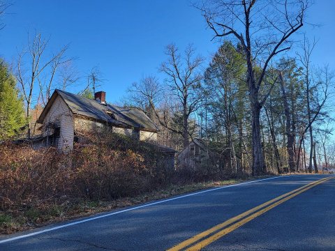 2024
 2012
 2012
 2010
 2009
 2009
