Freetown dates to 1659, and 12% of its homes were built before 1940
More historic than 90% of U.S. towns · #151 of 283 in Massachusetts. What drives it
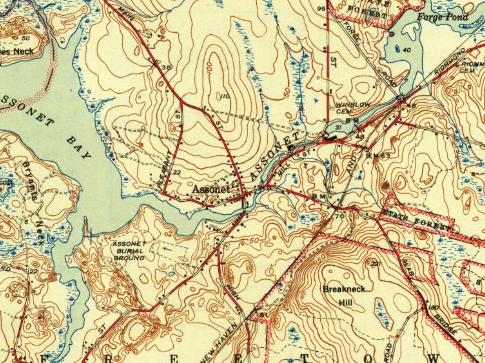
2 places in town are on the National Register, among them two historic districts with 167 buildings between them. Below: 4 old photos and papers, maps from 1885 on, and the census since 1790.
Founding year: Wikidata; Wikipedia’s history section gives the same year. First post office: 1809.The full story ↓
History grade
What drives Freetown’s History grade
On its age, its old homes and the National Register, Freetown is more historic than 90% of U.S. towns, #151 of 283 in Massachusetts. All 3 inputs are above most U.S. towns; its age ranks highest and its share of homes from before 1940 lowest.
A
HistoryA character grade: shown, never part of Freetown’s overall grade.
Massachusetts towns list more on the Register than most of the country (a typical Massachusetts town has 46.0 per 10,000 residents, the U.S. 2.4), so Freetown’s 180 sits above most of its state (74% of Massachusetts towns have fewer) while its 167 historic buildings outnumber those of 92% of U.S. towns.
How sure. Graded on any two of the three inputs instead, the letter would range from A− to A+. The pre-1940 share is a Census survey estimate (±3.8 points). Two sources give 1659.
Founding year: Wikidata (other dates in Quick answers). Homes: Census ACS 2020–24. National Register: National Park Service, May 2026 list; each listing counted once (boundary changes and added documentation belong to their listing), and a historic district counts its contributing buildings. How TownRatings grades history →
What stands out about Freetown’s past
Read from the archive, the National Register and the record. The page puts what stands out first.
Freetown was first settled by the English on April 2, 1659, on the banks of the Assonet River, when the areas of Assonet and Fall River were purchased for 20 coats, two rugs, two iron pots, two kettles, one little kettle, eight pairs of shoes, six pairs of stockings, one dozen hoes, one dozen hatchets, and two yards of broadcloth from the Wampanoag Indians in an exchange known as Ye Freemen's Purchase. Its population slowly grew, and it existed as a Proprietary settlement of the Plymouth Colony until it was officially incorporated in July 1683. It remained a part of Plymouth Colony until that colony merged with the Massachusetts Bay Colony in 1692. The town was the fifth municipal corporation established in Bristol County.
Passages that mention Freetown, cut from the printed page as they were published.
A History of the town of Freetown, Massachusetts1902 · page 45Read the page →
Read the text
The Christian community of the town of Freetown was thus organized for Christian work, worship and fellowship, substantially in the form which continues to this day. The two hamlets of East Freetown were provided with chapels, and the village of Assonet was doubly provided. Some of the more notable facts in the external history of the church since this time may be thus briefly stated.
Text read by machine from the scan; it may contain errors.
A History of the town of Freetown, Massachusetts1902 · page 247Read the page →
Read the text
Captain Levi Rounseville who marched from Freetown with his company of minute inen i\pril 1!>, 1775, was the father of the Rev. William Rounseville who represented the town of Freetown for ten successive years in the General Court at Boston, and great-grandfather of the Rev. William R. Alger, a noted author and divine. Lieutenant Nathaniel Morton of the same company was grandfather of Hon. Marcus Morton, formerly Governor of
Text read by machine from the scan; it may contain errors.
Scans and text from the Internet Archive. Books published in 1930 or earlier, which are in the public domain.
Timeline
Freetown, 1659 to 2020
Woven from the archive, old maps, post office records, the National Register and the people born here.
Nothing in the archives for these yearsWeddings on Main Street, storms, parades, school pictures, the old store. If it’s in your family album, it belongs here.
Nothing in the archives for these yearsWeddings on Main Street, storms, parades, school pictures, the old store. If it’s in your family album, it belongs here.
In 1659, according to Wikidata and Wikipedia’s history of the town. Freetown’s post office opened in 1809, and the first U.S. census counted 2,202 people here in 1790.
How does Freetown rank for history?
Freetown is more historic than 90% of U.S. towns, #151 of 283 in Massachusetts. The History grade combines the town’s founding era, the share of homes built before 1940 and its National Register listings. It’s a character grade, so it isn’t part of the overall grade. How it works.
What is on the National Register in Freetown?
Two places: the Assonet Historic District (listed 1999) and the East Freetown Historic District (1999).
How old are the homes in Freetown?
12% of Freetown’s homes were built before 1940 (Census estimate, ±3.8 points), against a typical 21% for a Massachusetts town; the median home was built in 1976.
Founding dates: Wikidata, Wikipedia, the U.S. post office records of Blevins & Helbock (CC0) and the Census. Homes by year built: Census ACS 2020–24. National Register of Historic Places: National Park Service (list of May 22, 2026). Old photos, postcards and papers: Wikimedia Commons, the Library of Congress and other public archives, credited on each item’s page. Maps: U.S. Geological Survey historical topographic maps (via Esri) and Sanborn fire-insurance maps (Library of Congress). History text and census tables: Wikipedia (CC BY-SA 4.0). Places that used to be: USGS Geographic Names Information System (2021).
From Wikimedia Commons (12), the National Register of Historic Places (2), Wikipedia, Wikidata and Wikipedia for famous people, U.S. Geological Survey historical maps, U.S. Census counts (via Wikipedia), the US Post Offices dataset (Blevins & Helbock), the USGS Geographic Names Information System and old county and town histories (Internet Archive). Archive images are copied here with their credits and licenses, shown on each photo’s page. Refreshed monthly.




 2017
 2010
 2010
 2010
 2010
 2010
 2010
 2010
