Bourne dates to 1640, and 18% of its homes were built before 1940
More historic than 83% of U.S. towns · #206 of 283 in Massachusetts. What drives it
9 places in town are on the National Register, among them a historic district with 3 buildings. Below: 19 old photos and papers, maps from 1886 on, and the census since 1890.
Bourne dates its founding to 1640 (Wikidata and Wikipedia’s history agree). The census first counted it in 1890.
First census: 1,442 in 18902020 census: 20,452386 years
How did Bourne get its name?
Bourne was named for Jonathan Bourne Sr. (1811–1889), whose ancestor Richard Bourne represented Sandwich in the first Massachusetts General Court and was the first preacher to the Mashpee Wampanoag on Cape Cod.
How historic is Bourne?
A−
More historic than 83% of U.S. towns, on its age, its old homes and the National Register.
Founding year: Wikidata; Wikipedia’s history section gives the same year. First post office: 1825. Name: Wikipedia, licensed CC BY-SA 4.0.The full story ↓
History grade
What drives Bourne’s History grade
On its age, its old homes and the National Register, Bourne is more historic than 83% of U.S. towns, #206 of 283 in Massachusetts. All 3 inputs are above most U.S. towns; its age ranks highest and its National Register listings lowest.
A−
HistoryA character grade: shown, never part of Bourne’s overall grade.
Massachusetts towns list more on the Register than most of the country (a typical Massachusetts town has 46.0 per 10,000 residents, the U.S. 2.4), so Bourne’s 6.4 sits below most of its state (24% of Massachusetts towns have fewer) while its 13 historic buildings outnumber those of 77% of U.S. towns.
How sure. Graded on any two of the three inputs instead, the letter would range from B to A. The pre-1940 share is a Census survey estimate (±4.0 points). Two sources give 1640.
Founding year: Wikidata (other dates in Quick answers). Homes: Census ACS 2020–24. National Register: National Park Service, May 2026 list; each listing counted once (boundary changes and added documentation belong to their listing), and a historic district counts its contributing buildings. How TownRatings grades history →
What stands out about Bourne’s past
Read from the archive, the National Register and the record. The page puts what stands out first.
Bourne was first settled in 1640 by Ezra Perry as a part of the town of Sandwich. Prior to its separation from Sandwich, the area was referred to as West Sandwich. It was officially incorporated in 1884, the last town to be incorporated in Barnstable County. It was named for Jonathan Bourne Sr. (1811–1889), whose ancestor Richard Bourne represented Sandwich in the first Massachusetts General Court and was the first preacher to the Mashpee Wampanoag on Cape Cod. The town lies at the northeast corner of Buzzards Bay and is the site of Aptucxet Trading Post, the nation's oldest store. It was founded by the Pilgrims in 1627 at a site halfway between the two rivers which divided Cape Cod from the rest of the state. It was out of this location that the Cape Cod Canal was formed, in order to save time and lives by eliminating the need to sail around the hazardous eastern shores of the Cape. Be…
Passages that mention Bourne, cut from the printed page as they were published.
History of Barnstable County, Massachusetts, 1620-1637-1686-18901890 · page 323Read the page →
Read the text
THE territory embraced in the present town of Bourne, having been included for more than two hundred years in the town of Sandwich, the reader will refer to the preceding chapter for a more minute political and civil history of both prior to the separation in 1884. The early settlement and development of villages and communities within the limits of Bourne are regarded as the beginnings of this town, and will so appear as far as the early records are separable. While a careful examination of the proprietors' records
Text read by machine from the scan; it may contain errors.
History of Barnstable County, Massachusetts, 1620-1637-1686-18901890Read the page →
Read the text
Bef:re the town of Sandwich was divided, he, in 1876, was elected overseer of the poor, and in 1879 was elected selectman of the town, which offices, with that of assessor, he satisfactorily filled until the spring of 1884, when the town of Bourne was erected. In the new town he was at once elected to the same responsible offices, which he has since filled, and since 1884 he has been chairman of the selectmen of Bourne. He also has been appointed a justice of the peace and a notary public, enjoying the entire confidence of his townsmen in the
Text read by machine from the scan; it may contain errors.
In 1694, Nov. 28, the Rev. Mr. Cotton was ordained.1 In 1695, Richd. Allen and Timo. Bourne were ad. townsmen. — u The town did give to those of their neighbors called Quakers, half an acre of ground for a burial-place, on the hill above the Canoe Swamp between the ways." — "Liberty was gr. to Elisha Bourne to set up a grist-mill upon Herring River, provided the toll shall not exceed 2 qte. pr. bu." — ** Voted to give back to Mr.
Text read by machine from the scan; it may contain errors.
Scans and text from the Internet Archive. Books published in 1930 or earlier, which are in the public domain.
By decade
Bourne, decade by decade
5 decades in the archive, from the 1850s to the 1910s. Scroll each row; tap a photo for its story.
Nothing in the archives for these yearsWeddings on Main Street, storms, parades, school pictures, the old store. If it’s in your family album, it belongs here.
Fire insurance maps drew every building, what it was made of and what it was used for, so insurers could price the risk of fire. Pick a year, then a sheet.
In 1640, according to Wikidata and Wikipedia’s history of the town. Bourne’s post office opened in 1825, and the census of 1890 counted 1,442 people here.
How does Bourne rank for history?
Bourne is more historic than 83% of U.S. towns, #206 of 283 in Massachusetts. The History grade combines the town’s founding era, the share of homes built before 1940 and its National Register listings. It’s a character grade, so it isn’t part of the overall grade. How it works.
What is on the National Register in Bourne?
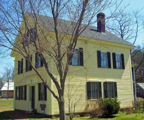
9 listings: 7 buildings, among them the George I. Briggs House (listed 1981, the first), 1 historic district, the Aptucxet Trading Post Museum Historic District, with 3 contributing buildings, and 1 structure. 13 historic buildings in all.
How old are the homes in Bourne?
18% of Bourne’s homes were built before 1940 (Census estimate, ±4.0 points), against a typical 21% for a Massachusetts town; the median home was built in 1975.
Founding dates: Wikidata, Wikipedia, the U.S. post office records of Blevins & Helbock (CC0) and the Census. Homes by year built: Census ACS 2020–24. National Register of Historic Places: National Park Service (list of May 22, 2026). Old photos, postcards and papers: Wikimedia Commons, the Library of Congress and other public archives, credited on each item’s page. Maps: U.S. Geological Survey historical topographic maps (via Esri) and Sanborn fire-insurance maps (Library of Congress). History text and census tables: Wikipedia (CC BY-SA 4.0). Places that used to be: USGS Geographic Names Information System (2021).
From Wikimedia Commons (19), Wikidata (5), the National Register of Historic Places (9), Wikipedia, Wikidata and Wikipedia for famous people, U.S. Geological Survey historical maps, U.S. Census counts (via Wikipedia), the US Post Offices dataset (Blevins & Helbock), the USGS Geographic Names Information System, Sanborn fire insurance maps (Library of Congress) and old county and town histories (Internet Archive). Archive images are copied here with their credits and licenses, shown on each photo’s page. Refreshed monthly.




 1880
 1898
 1906
 1907–1915
 c. 1907
 c. 1907
 c. 1907
 1907–1915
 1907–1915
 1907–1915
 1908
 c. 1909
 c. 1911
 c. 1911


