South Bend’s post office opened in 1830, and 28% of its homes were built before 1940
More historic than 95% of U.S. towns · #76 of 593 in Indiana. What drives it
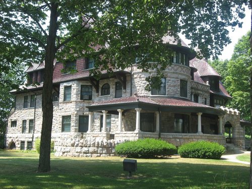
78 places in town are on the National Register, among them the Tippecanoe Place, a National Historic Landmark, and ten historic districts with 1,286 buildings between them. Below: 18 old photos and papers, maps from 1983 on, and the census since 1850.
The South Bend post office opened in 1830, the earliest record of the town by name. Wikidata gives 1865. Four smaller post offices, Southold (1829), Portage (1841) and West York (1852), opened inside today’s city and later closed.
First census: 1,652 in 18502020 census: 103,453196 years
How historic is South Bend?
A
More historic than 95% of U.S. towns, on its age, its old homes and the National Register.
Founding year: the first South Bend post office (Blevins & Helbock, CC0). Wikidata: 1865.The full story ↓
History grade
What drives South Bend’s History grade
On its age, its old homes and the National Register, South Bend is more historic than 95% of U.S. towns, #76 of 593 in Indiana. All 3 inputs are above most U.S. towns; its National Register listings ranks highest and its age lowest.
A
HistoryA character grade: shown, never part of South Bend’s overall grade.
Among the 400 U.S. cities of 100,000 or more, South Bend ranks #46 on History.
Indiana towns list more on the Register than most of the country (a typical Indiana town has 7.9 per 10,000 residents, the U.S. 2.4), so South Bend’s 132 sits above most of its state (84% of Indiana towns have fewer) while its 1,363 historic buildings outnumber those of 99% of U.S. towns.
How sure. Graded on any two of the three inputs instead, the letter would still be A. The pre-1940 share (±1.4 points) is firm at this size. The founding year is the first post office, not a stated founding date; Wikidata gives 1865.
Founding year: the first post office (other dates in Quick answers). Homes: Census ACS 2020–24. National Register: National Park Service, May 2026 list; each listing counted once (boundary changes and added documentation belong to their listing), and a historic district counts its contributing buildings. How TownRatings grades history →
What stands out about South Bend’s past
Read from the archive, the National Register and the record. The page puts what stands out first.
National Park Service, National Register of Historic Places. Photos from Wikimedia Commons, credited on each place’s page.
Places that used to be
Lost post offices, old corners, places now gone and burying grounds
South Bend’s post office has been open since 1830. Four other post offices opened and closed inside today’s town.
Southold
1829–1830
South Bend
1830–today
Portage
1841–1844
West York
1852–1860
Holy Cross
1935–1936
18201920today
Hamlets and corners on the map
Crest Manor AdditionMaple Lane
Gone or out of use
Esther Landing Pad AirportairportIndiana University at South Bend AirportairportMcClures AirportairportSouth Bend Sand and Gravel PitmineWest York Post Officepost office
3cemeteries and burying grounds inside South Bend
BowmanHighlandRiverview
US Post Offices dataset (Blevins & Helbock, CC0). Places and cemeteries from the USGS Geographic Names Information System (2021).
The St. Joseph Valley was long occupied by Native Americans. One of the earliest known groups to occupy what would later become northern Indiana was the Miami tribe. Later, the Potawatomi moved into the region, utilizing the rich food and natural resources found along the river. The Potawatomi occupied this region of Indiana until most of them were forcibly removed in the 1840s. The South Bend area was popular because its portage was the shortest overland route from the St. Joseph River to the Kankakee River. This route was used for centuries, first by the Native Americans, then by French explorers, missionaries and traders. The French explorer René-Robert Cavelier, Sieur de La Salle, the first white European to set foot in what is now South Bend, used this portage between the St. Joseph River and the Kankakee River in December 1679.
Passages that mention South Bend, cut from the printed page as they were published.
South Bend and the men who have made it. Historical, descriptive, biographical1901 · page 438Read the page →
Read the text
Until he had reached his majority young Gard lived at home and attended the district schools in the vicinity of his home and assisted on the farm. In 1885 he came to South Bend where he attended the public schools, and then went to Du Pauw Unive:sity. He returned to South Bend and was employed by the South Bend Street Railway Company, and then went
Text read by machine from the scan; it may contain errors.
South Bend and the men who have made it. Historical, descriptive, biographical1901 · page 362Read the page →
Read the text
and removed to Indiana, settling in Lagrange County, where he engaged in farming pur¬ suits until 1862. In Apm Ox. that year he came to South Bend where he purchased a tract of land on the Michigan road and lying between the Elder farm and what was then the village of South Bend. This proved a most lucrative investment and the land is now
Text read by machine from the scan; it may contain errors.
A history of St. Joseph County, Indiana1907 · page 229Read the page →
Read the text
Fellows, Garrett V. Denniston and others, all from the state of New York, purchased from Alexis Coquillard the water powder and rights at South Bend. Early the next year, by an act approved February 6, 1836,® they likewise procured a charter to build a dam across the river "at the head of the rapids, at or near the town of South Bend." The conditions
Text read by machine from the scan; it may contain errors.
A history of St. Joseph County, Indiana1907 · page 323Read the page →
Read the text
This was the first town incorporation in St. Joseph county, preceding by a few montlis the incorporation of the town of South Bend. II. BUSINESS ENTERPRISES. From the beginning Mishawaka has been noted for its business enterprise. The founders and early settlers of the town were
Text read by machine from the scan; it may contain errors.
Scans and text from the Internet Archive. Books published in 1930 or earlier, which are in the public domain.
Timeline
South Bend, 1829 to 1964
Woven from the archive, old maps, post office records, the National Register and the people born here.
Nothing in the archives for these yearsWeddings on Main Street, storms, parades, school pictures, the old store. If it’s in your family album, it belongs here.
The South Bend post office opened in 1830, the earliest record of the town by name (U.S. post office records). Wikidata gives 1865.
How does South Bend rank for history?
South Bend is more historic than 95% of U.S. towns, #76 of 593 in Indiana. The History grade combines the town’s founding era, the share of homes built before 1940 and its National Register listings. It’s a character grade, so it isn’t part of the overall grade. How it works.
What is on the National Register in South Bend?
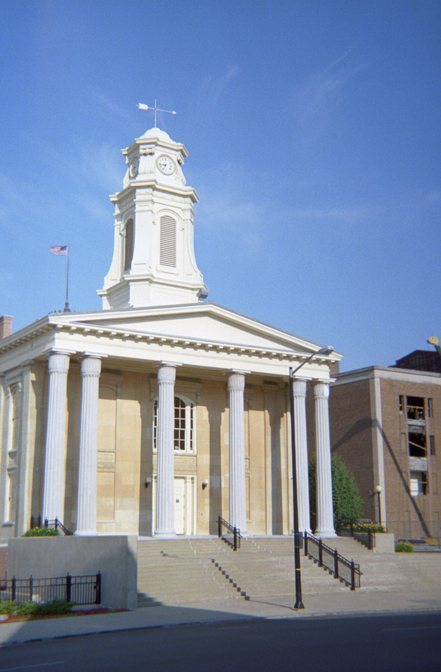
78 listings: 61 buildings, among them the Tippecanoe Place (a National Historic Landmark since 1977) and the Old Courthouse (Second St. Joseph County Courthouse) (listed 1970, the first), 14 historic districts with 1,286 contributing buildings, 1 site, and 2 structures. 1,363 historic buildings in all.
How old are the homes in South Bend?
28% of South Bend’s homes were built before 1940 (Census estimate, ±1.4 points), against a typical 14% for an Indiana town; the median home was built in 1955.
Founding dates: Wikidata, Wikipedia, the U.S. post office records of Blevins & Helbock (CC0) and the Census. Homes by year built: Census ACS 2020–24. National Register of Historic Places: National Park Service (list of May 22, 2026). Old photos, postcards and papers: Wikimedia Commons, the Library of Congress and other public archives, credited on each item’s page. Maps: U.S. Geological Survey historical topographic maps (via Esri) and Sanborn fire-insurance maps (Library of Congress). History text and census tables: Wikipedia (CC BY-SA 4.0). Places that used to be: USGS Geographic Names Information System (2021).
From Wikimedia Commons (14), the Library of Congress (4), Wikidata (4), the National Register of Historic Places (78), Wikipedia, Wikidata and Wikipedia for famous people, U.S. Geological Survey historical maps, U.S. Census counts (via Wikipedia), the US Post Offices dataset (Blevins & Helbock), the USGS Geographic Names Information System and old county and town histories (Internet Archive). Archive images are copied here with their credits and licenses, shown on each photo’s page. Refreshed monthly.


 ★ Landmark




 1859
 1896
 1898
 1908
 1908
 1908
 1909
 1909
 1910
 1914
 1918
 c. 1924


