Most of South Woodstock was built recently: 9% of its homes predate 1940 and the median home dates from 1984. Below: maps from 1889 on and old-book passages.
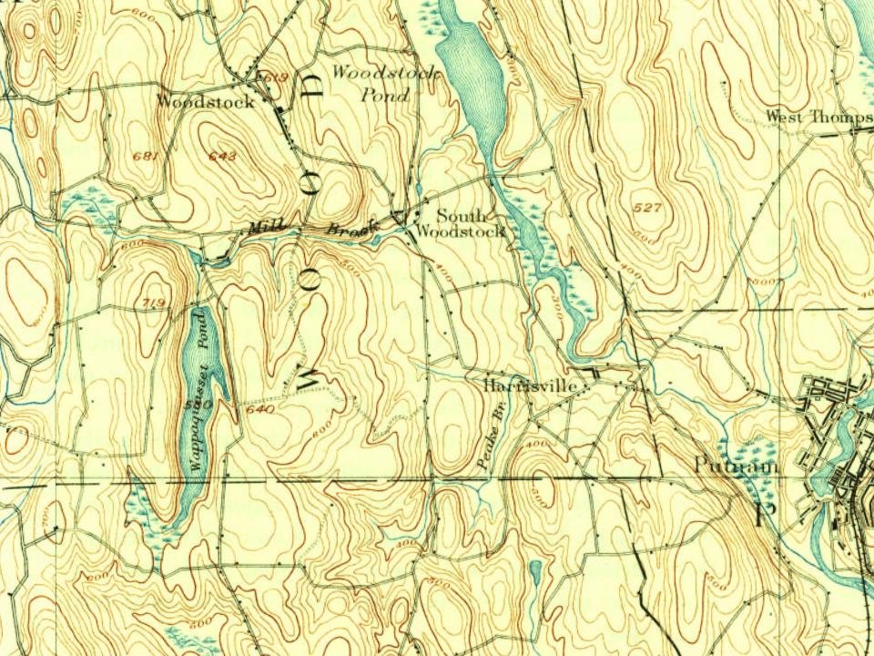
Every edition of the U.S. Geological Survey’s map of South Woodstock. Tap a year, or press play to watch the town change.
1889Putnam sheet · 1:62,500
U.S. Geological Survey historical topographic maps (public domain), via Esri’s collection of the scans. The red ring marks the center of South Woodstock.
The story so far
South Woodstock, in brief
Wikipedia doesn’t have a history of South Woodstock yet. The photos, dates and memories neighbors add here are how it gets written.
South Woodstock is a village and census-designated place (CDP) in Woodstock, Connecticut, United States. As of the 2020 census, South Woodstock had a population of 1,493. It is notable as the former home of the now-defunct Annhurst College.
Its first post office opened in 1862. Between the 2010 and 2020 censuses its population grew from 1,291 to 1,493 (+16%).
Intro from Wikipedia. Population: U.S. Census Bureau.
From the old history books
What they wrote about South Woodstock, 1889–1920
Passages that mention South Woodstock, cut from the printed page as they were published.
History of Windham County, Connecticut ..1889 · page 904Read the page →
Read the text
Woodstock's first post ofifice was opened in Bowen's store in 1811, George Bowen, postmaster. Six offices are now needed, one for each separate village, viz., Woodstock, East, West, North, South Woodstock and Woodstock Valley. Convenient mail carriages convey the mail from Putnam depot to these several stations. These villages, dating back many years, enjoy varying degrees of prosperity. Some have lost by business changes and emigration; others gained by new interests. The summer
Text read by machine from the scan; it may contain errors.
A modern history of Windham county, Connecticut1920 · page 579Read the page →
Read the text
now with a membership of only about forty they are bravely holding the fort in the cause of righteousness and. striving to keep alive the Christian spirit and life in that part of the town. The South Woodstock Church was formed in 1792 with strong men like Deacon William Manning, the Arnolds, and Sawyers and Wells families among its early members. The first meeting-house was built about one mile west of the present edifice, just north of the Quassett cemetery.
Text read by machine from the scan; it may contain errors.
A modern history of Windham county, Connecticut1920 · page 829Read the page →
Read the text
As one enters the Village of Woodstock over the ascending highway from South Woodstock, he becomes conscious of the heights he must have climbed since leaving Putnam, as glimpses of far-distant bine and purple hills and the varying features of the landscape stand revealed beyond the attractive country homes and the double rows of trees which fringe the street on either side.
Text read by machine from the scan; it may contain errors.
Scans and text from the Internet Archive. Books published in 1930 or earlier, which are in the public domain.
Founding dates: Wikidata, Wikipedia, the U.S. post office records of Blevins & Helbock (CC0) and the Census. Homes by year built: Census ACS 2020–24. National Register of Historic Places: National Park Service (list of May 22, 2026). Old photos, postcards and papers: Wikimedia Commons, the Library of Congress and other public archives, credited on each item’s page. Maps: U.S. Geological Survey historical topographic maps (via Esri) and Sanborn fire-insurance maps (Library of Congress). History text and census tables: Wikipedia (CC BY-SA 4.0). Places that used to be: USGS Geographic Names Information System (2021). How TownRatings grades history →
From Wikimedia Commons (6), Wikidata and Wikipedia for famous people, U.S. Geological Survey historical maps and old county and town histories (Internet Archive). Archive images are copied here with their credits and licenses, shown on each photo’s page. Refreshed monthly.




 2024
 2024
 2023
 2023
 2012
 2009