 Top
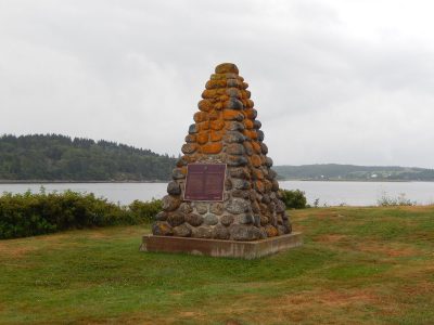
National Historic Site · 1632–1633Fort Sainte Marie de GracePhoto: Fralambert · CC BY-SA 4.0 · Commons file
 Fort Sainte Marie de Grace · Photo: Fralambert · CC BY-SA 4.0
2historic places on the registers
History of Lunenburg · Canada’s heritage registers
Lunenburg’s oldest designated place, Fort Sainte Marie de Grace, dates from 1632
Before 1961: 32% of Lunenburg’s homes, where most towns have 18%. The registers put 2 historic places inside its boundary, one of them of the highest rank. For every 10,000 residents that makes 0.7, ahead of 77% of Canadian towns. The list takes in a Recognized Federal Heritage Building.
Historic places
2
0.7 per 10,000 residents
Highest designations
1
National Historic Sites and Classified Federal Heritage Buildings
Other federal designations
1
Recognized buildings, railway stations, lighthouses
Oldest building
1632
the first construction date on its record
Homes built before 1961
32%
typical town: 18%
The map
Where Lunenburg’s history is
Every place on the registers inside the town, by its designation.
Highest designationsOther federal designations
Tap any dot to open that place’s own page; hovering shows its name.
The 2, by tier
1 Highest designations1 Other federal designations
Federal designations come from Parks Canada’s directory; a province’s or a council’s own listing shows here only when Wikidata holds it and an encyclopedia covers it.
Points from Wikidata (Parks Canada’s files carry none) and from Québec’s register, as mapped there.
Highest designations
The highest rank in Lunenburg: one place
National Historic Sites and Classified Federal Heritage Buildings, Canada’s highest federal recognition. Each one opens its own page.
Other federal designations
One more federal designation in Lunenburg
Recognized Federal Heritage Buildings, heritage railway stations and lighthouses. Each one opens its own page.
Recognized Federal Heritage BuildingEast Ironbound Combined Lighthouse and Dwelling
Around the town
The highest designation, 4 times, within 25 km of Lunenburg
Closest of all is Lunenburg Academy, in Lunenburg, 15 km off. Count to 25 km and there are 6. Among them are 4 National Historic Sites and 2 provincial or municipal listings.
The 6 nearest, within 25 km
| Lunenburg AcademyNational Historic Site · 1894–1896 · 15 km away, in Lunenburg |
| Zion Evangelical Lutheran ChurchMunicipally Registered Property · 1891 · 15 km away, in Lunenburg |
| St. John's Anglican ChurchNational Historic Site · 1754–1764 · 15 km away, in Lunenburg |
| Knaut-Rhuland HouseNational Historic Site · 1793–1794 · 16 km away, in Lunenburg |
| Old Town Lunenburg Historic DistrictNational Historic Site · 1753–1992 · 16 km away, in Lunenburg |
| St. Andrew's Presbyterian ChurchMunicipally Registered Property · 1828 · 16 km away, in Lunenburg |
Homes by age
Lunenburg added few homes from 2016 to 2021: 3.1%, where most towns have 4.1%
Count back from today and half of Lunenburg’s homes are older than 1981. In Lunenburg, 28% of homes date from 1961 to 1980, much as in most towns (27%). 24% of Lunenburg’s homes were built from 1981 to 2000, close to the typical town’s 23%.
32%
Before 1961
28%
1961–80
24%
1981–2000
13%
2001–15
3.1%
2016–21
LunenburgTypical town
2021 Census, private dwellings by period of construction (Statistics Canada); the typical town is the middle Canadian town of 2,500 or more.
Born here
Lives begun in Lunenburg between 1844 and 1908
Fame, by Wikipedia: Angus MacLennan first, in 3 languages. The record holds 4 people born here before 1914. Gordon E. Romkey lived longest, to 92, dying in 1977.
Angus MacLennan
Gordon E. Romkey
George O. Lohnes
Fraser Herman
1800182518501875190019251950

Angus MacLennan1844–1908 · Canadian politician
FH
Fraser Herman1908–1972 · Canadian rower
GR
Gordon E. Romkey1885–1977 · Canadian politician
GL
George O. Lohnes1898–1982 · Canadian politician
Everyone born in Lunenburg → Born before 1914 (the page’s periods: Confederation to the First World War). Birthplaces from Wikidata, each checked against the person’s Wikipedia article.
Towns its size
Lunenburg has the 3rd most of 16 towns its size
Towns of 26,500 to 27,300 residents, by places on the registers.
Lunenburg2
Just these have more: La Prairie and Sainte-Thérèse. Their median is 0. 9 of them have none.
Neighbours
Lunenburg and its neighbours
| Town | People | Places | Highest | Oldest |
|---|---|---|---|---|
| Lunenburg | 26,862 | 2 | 1 | 1632 |
| Bridgewater | 9,989 | 0 | 0 | — |
| Mahone Bay | 1,200 | 0 | 0 | — |
| Lunenburg | 2,523 | 6 | 4 | 1753 |
In brief
Lunenburg in brief
The pre-1961 share of Lunenburg’s homes is 32%, against 18% in the typical town. The lists come to 2 historic places, one with the highest designation, including Fort Sainte Marie de Grace. Of the 16 towns closest in size, just 2 have more historic places. Angus MacLennan (1844), Fraser Herman (1908) and Gordon E. Romkey (1885) are the best known of its historic lives. Otherwise the figures are ordinary: its places were designated between 1924 and 2006.
How to read these numbers
What this data can and can’t tell you
- The federal register. The federal list is complete and open: Parks Canada’s directory for the designations, the Canadian Register of Historic Places for what each one is and why it matters.
- Provincial and municipal lists. Outside Québec, provinces’ and municipalities’ heritage registers aren’t open data; their places are known only through Wikidata items with a register number, and only those with an encyclopedia article get a page.
- Protection. Being on these registers doesn’t mean a building can’t change. Federal designation commemorates; protection is provincial or municipal, and those lists aren’t open here.
- The tiers. Tiers follow the designation: national recognition and classement first, other federal designations next, provincial and local listings last.
- People and events. National historic persons carry no place in the open file. They appear on a town’s page when born there (same name, same birth and death years) or when a historic place inside it carries their name and its record names them with their dates; national historic events don’t appear.
- Map points. Parks Canada publishes no coordinates, so federal places are pinned where Wikidata puts them.
- The grade. There is no history grade: the page sets out the record and compares it with other towns.
Questions about Lunenburg’s history
What is the oldest building in Lunenburg?
Fort Sainte Marie de Grace (National Historic Site): the first construction date on its record is 1632.
Which places in Lunenburg have the highest designation?
It is Fort Sainte Marie de Grace.
How old are the homes in Lunenburg?
32% of its homes were built before 1961, against 18% in the typical Canadian town.
Why might a heritage building in Lunenburg be missing here?
Provincial and municipal registers outside Québec aren’t open data. Wikidata knows 12 more listings in Lunenburg, but without an open description or an encyclopedia article they get no page.
Contains information licensed under the Open Government Licence – Canada (Parks Canada).
Sources: Parks Canada, Directory of Federal Heritage Designations · Canadian Register of Historic Places (federal extract) · Wikidata (CC0) for map points, other names and articles · Statistics Canada, 2021 Census (homes by period of construction). Under the Statistics Canada Open Licence.
Adapted from Statistics Canada (Census of Population 2021, population estimates 2025, 2021 census boundaries) under the Statistics Canada Open Licence; this does not constitute an endorsement by Statistics Canada. Neighbourhood names in some cities © OpenStreetMap contributors (ODbL).