 Photo: waferboard · CC BY 2.0
The heritage near Port Moody: 43 places in a 25 km radius
Homes from before 1961 are 6.9% of the stock, under the 18% of the typical town. Old photographs of Port Moody span 1886 to 1914: 2 in all. Strathcona, 18 km away, has the nearest place of the highest rank.
Port Moody from 1886 to 1914
Set out by date: 2 old photographs of the town. A tap on any picture opens it with its credit.
 c. 1886
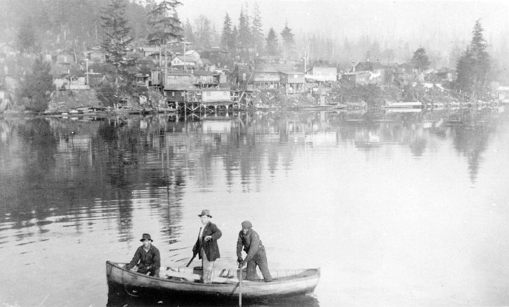 c. 1914
Public domain or CC0, made before 1950, from Wikimedia Commons; old views of places can be drawings, prints or maps of their time. Each credit opens the image’s page.
Within 25 km of Port Moody, 14 top designations
Count to 25 km and there are 43. By age, Fort Langley leads, from 1839, at 24 km. Closest of all is Holy Trinity Cathedral, in New Westminster, 11 km off.
The 12 nearest, within 25 km
| Holy Trinity CathedralListed in a community heritage register · 1902 · 11 km away, in New Westminster |
| Hastings ParkProvincially Recognized Heritage Site · 1888 · 14 km away, in Hastings-Sunrise |
| First Church of Christ, ScientistListed in a community heritage register · 1925 · 17 km away, in North Vancouver |
| Victoria ParkListed in a community heritage register · 1905 · 17 km away, in North Vancouver |
| Burrard Dry DockHeritage designation · 17 km away, in North Vancouver |
| Saint Paul's Roman Catholic ChurchNational Historic Site · 1884–1885 · 18 km away, in North Vancouver |
| Vancouver Japanese Language SchoolNational Historic Site · 1928–1929 · 18 km away, in Strathcona |
| Kuomintang BuildingHeritage designation · 18 km away, in Strathcona |
| Ovaltine CafeListed in a community heritage register · 1912 · 18 km away, in Strathcona |
| Canadian National Railways / VIA Rail Station, Vancouver, British ColumbiaHeritage Railway Station · 1917–1918 · 18 km away, in Strathcona |
| Vancouver's ChinatownNational Historic Site · 1880–2003 · 18 km away, in Strathcona |
| Carnegie Community CentreHeritage designation · 18 km away, in Yaletown |
Within 25 km of Port Moody, the record goes back to 1839
The area here stretches to 25 km around Port Moody: each historic place by the first construction date it records.
The oldest is Fort Langley in Langley, from 1839. The chart rests on 37 dated places within 25 km. 2 are older than 1867.
Most of Port Moody’s homes went up from 2001 to 2015: 34%
Over half of the homes in Port Moody were already standing by 2001. Homes built from 1981 to 2000 make up 29% of Port Moody’s, against 23% in the typical town. From 2016 on, Port Moody built 3.9% of its homes, near the typical 4.1%.
2021 Census, private dwellings by period of construction (Statistics Canada); the typical town is the middle Canadian town of 2,500 or more.
How Port Moody compares with 16 towns its size
Towns of 37,200 to 39,400 residents, by places on the registers.
9 have more. The typical town its size has 1. 7 of them have nothing on the registers.
Port Moody and its neighbours
| Town | People | Places | Highest | Oldest |
|---|---|---|---|---|
| Port Moody | 38,285 | 0 | 0 | — |
| Anmore | 2,508 | 0 | 0 | — |
| Coquitlam | 173,599 | 0 | 0 | — |
| Burnaby Mountain | 9,248 | 0 | 0 | — |
| Lougheed | 15,442 | 0 | 0 | — |
| Port Coquitlam | 67,724 | 0 | 0 | — |
| Lake City | 3,240 | 0 | 0 | — |
Port Moody in brief
Its housing is young: only 6.9% predates 1961, against 18% in the typical town. Towns its size usually have more historic places; the middle one has 1.
What this data can and can’t tell you
- The tiers. Tiers follow the designation: national recognition and classement first, other federal designations next, provincial and local listings last.
- Provincial and municipal lists. Outside Québec, provinces’ and municipalities’ heritage registers aren’t open data; their places are known only through Wikidata items with a register number, and only those with an encyclopedia article get a page.
- Protection. Being on these registers doesn’t mean a building can’t change. Federal designation commemorates; protection is provincial or municipal, and those lists aren’t open here.
- The grade. There is no history grade: the page sets out the record and compares it with other towns.
- People and events. Parks Canada’s open file gives its national historic persons no place. A town’s page names one only when the person was born there (matched by name and both life years) or one of its own historic places carries the name and its record speaks of them; national historic events stay off.
- The federal register. Every federal designation is in Parks Canada’s directory, and the Canadian Register of Historic Places gives most of them a bilingual statement of significance.
Questions about Port Moody’s history
How many historic places does Port Moody have on the registers?
None within Port Moody itself; the nearest is 11 km off: Holy Trinity Cathedral, in New Westminster.
How old are the homes in Port Moody?
The 2021 Census dates 6.9% of its homes before 1961 (18% in the typical town).
Contains information licensed under the Open Government Licence – Canada (Parks Canada).
Sources: Parks Canada, Directory of Federal Heritage Designations · Canadian Register of Historic Places (federal extract) · Wikidata (CC0) for map points, other names and articles · Statistics Canada, 2021 Census (homes by period of construction). Under the Statistics Canada Open Licence.
Adapted from Statistics Canada (Census of Population 2021, population estimates 2025, 2021 census boundaries) under the Statistics Canada Open Licence; this does not constitute an endorsement by Statistics Canada. Neighbourhood names in some cities © OpenStreetMap contributors (ODbL).