Pleasanton’s post office opened in 1867, and 2 of its places are on the National Register
More historic than 32% of U.S. towns · #325 of 847 in California. What drives it
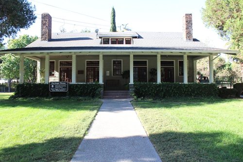
Most of Pleasanton was built recently: 1% of its homes predate 1940 and the median home dates from 1984. Its Register listings are the Kottinger, John W., Adobe Barn and the Heathcote-MacKenzie House. Below: 5 old photos and papers, maps from 1888 on, and the census since 1870.
Founding year: the first Pleasanton post office (Blevins & Helbock, CC0).The full story ↓
History grade
What drives Pleasanton’s History grade
On its age, its old homes and the National Register, Pleasanton is more historic than 32% of U.S. towns, #325 of 847 in California. Its National Register listings hold the grade up; its share of homes from before 1940 pulls it down.
C
HistoryA character grade: shown, never part of Pleasanton’s overall grade.
Few California towns list much on the Register (a typical California town has 0.0 per 10,000 residents, the U.S. 2.4), so Pleasanton’s 0.3 sits above most of its state (66% of California towns have fewer) while its 2 listings outnumber those of 60% of U.S. towns.
How sure. Graded on any two of the three inputs instead, the letter would range from C− to B−. The pre-1940 share (±0.5 points) is firm at this size. The founding year is the first post office, not a stated founding date.
Founding year: the first post office (other dates in Quick answers). Homes: Census ACS 2020–24. National Register: National Park Service, May 2026 list; each listing counted once (boundary changes and added documentation belong to their listing), and a historic district counts its contributing buildings. How TownRatings grades history →
What stands out about Pleasanton’s past
Read from the archive, the National Register and the record. The page puts what stands out first.
Fire insurance maps drew every building, what it was made of and what it was used for, so insurers could price the risk of fire. Pick a year, then a sheet.
The Amador-Livermore Valley, where Pleasanton is located, was home to tribes in the Ohlone language group, mainly speaking Chochenyo. As of the 1770s seven tribes were present in the valley: the Causen, Pelnen, Seunen, Ssaoan, Ssouyen, Taunan, and Yulien. Each had a territory about 10 miles across, living in villages of 60-90 people. The total population of the valley was about 2000-2500 people.
The first Spanish expedition reached the Amador-Livermore Valley in 1772. Native people from the valley began to join Mission Santa Clara, founded in 1777, in small numbers by the 1790s. Large groups began joining missions after Mission San Jose was founded in 1797.
Passages that mention Pleasanton, cut from the printed page as they were published.
History of Alameda County, California1883 · page 837Read the page →
Read the text
which, after two years' service, he was discharged and re-enlisted in Company F, Twentieth New York Regiment, serving in this corps until the close of the war. In 1865 he came to California, located at Folsom, Sacramento County, and was in charge of the post-office there until 1869, when he moved to Pleasanton, and was the first agent of the Western Pacific Railroad Company there. Resigning this position in 1871, he moved to Suhol and opened the present railroad office there. In the following year he commenced operations in his present store, and in 1874 erected the first warehouse in that place, constructing another like edifice in 1875. Married, September
Text read by machine from the scan; it may contain errors.
History of Alameda County, California1883 · page 954Read the page →
Read the text
on an eighty-acre farm on Dry Creek, Washington Township in this county, bought by C. Duerr for Nusbaumer and himself October, 1857, Duerr and Nusbaumer rented the estate of John W. Kottinger, situated in Murray Township, embracing the larger part of the present town of Pleasanton for a term of five years. Their business here consisted of merchandising and sheep-raising. At the expiration of their lease 1862, they bought a joint interest in the Rancho El Valle de San Jos^ consisting of some three thousand acres, on part of which they made their permanent home.
Text read by machine from the scan; it may contain errors.
Scans and text from the Internet Archive. Books published in 1930 or earlier, which are in the public domain.
Timeline
Pleasanton, 1867 to 1998
Woven from the archive, old maps, post office records, the National Register and the people born here.
Nothing in the archives for these yearsWeddings on Main Street, storms, parades, school pictures, the old store. If it’s in your family album, it belongs here.
The Pleasanton post office opened in 1867, the earliest record of the town by name (U.S. post office records).
How does Pleasanton rank for history?
Pleasanton is more historic than 32% of U.S. towns, #325 of 847 in California. The History grade combines the town’s founding era, the share of homes built before 1940 and its National Register listings. It’s a character grade, so it isn’t part of the overall grade. How it works.
What is on the National Register in Pleasanton?
Two places: the Kottinger, John W., Adobe Barn (listed 1985) and the Heathcote-MacKenzie House (1991).
How old are the homes in Pleasanton?
1% of Pleasanton’s homes were built before 1940 (Census estimate), against a typical 3.4% for a California town; the median home was built in 1984.
Founding dates: Wikidata, Wikipedia, the U.S. post office records of Blevins & Helbock (CC0) and the Census. Homes by year built: Census ACS 2020–24. National Register of Historic Places: National Park Service (list of May 22, 2026). Old photos, postcards and papers: Wikimedia Commons, the Library of Congress and other public archives, credited on each item’s page. Maps: U.S. Geological Survey historical topographic maps (via Esri) and Sanborn fire-insurance maps (Library of Congress). History text and census tables: Wikipedia (CC BY-SA 4.0). Places that used to be: USGS Geographic Names Information System (2021).
From Wikimedia Commons (10), the Library of Congress (4), Wikidata (2), the National Register of Historic Places (2), Wikipedia, Wikidata and Wikipedia for famous people, U.S. Geological Survey historical maps, U.S. Census counts (via Wikipedia), the US Post Offices dataset (Blevins & Helbock), the USGS Geographic Names Information System, Sanborn fire insurance maps (Library of Congress) and old county and town histories (Internet Archive). Archive images are copied here with their credits and licenses, shown on each photo’s page. Refreshed monthly.


 1902
 1902
 Date?
 2026
 2021
 2018
 2017
 2016
 2016
 2010
 2003
 2003