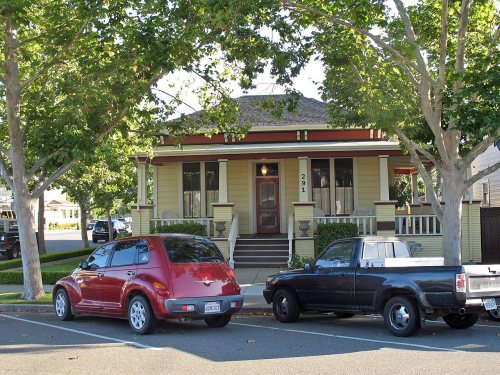
Livermore dates to 1869, and 6 of its places are on the National Register
More historic than 44% of U.S. towns · #191 of 847 in California. What drives it
Most of Livermore was built recently: 3% of its homes predate 1940 and the median home dates from 1979. 6 places in town are on the National Register, among them a historic district with 9 buildings. Below: 5 old photos and papers, maps from 1884 on, and the census since 1880.
Founding year: Wikidata. First post office: 1869.The full story ↓
History grade
What drives Livermore’s History grade
On its age, its old homes and the National Register, Livermore is more historic than 44% of U.S. towns, #191 of 847 in California. Its National Register listings hold the grade up; its share of homes from before 1940 pulls it down.
C+
HistoryA character grade: shown, never part of Livermore’s overall grade.
Few California towns list much on the Register (a typical California town has 0.0 per 10,000 residents, the U.S. 2.4), so Livermore’s 1.9 sits above most of its state (80% of California towns have fewer) while its 16 historic buildings outnumber those of 78% of U.S. towns.
How sure. Graded on any two of the three inputs instead, the letter would range from C− to B. The pre-1940 share (±0.7 points) is firm at this size. Two sources give 1869.
Founding year: Wikidata (other dates in Quick answers). Homes: Census ACS 2020–24. National Register: National Park Service, May 2026 list; each listing counted once (boundary changes and added documentation belong to their listing), and a historic district counts its contributing buildings. How TownRatings grades history →
What stands out about Livermore’s past
Read from the archive, the National Register and the record. The page puts what stands out first.
Fire insurance maps drew every building, what it was made of and what it was used for, so insurers could price the risk of fire. Pick a year, then a sheet.
The valley and upland areas where contemporary Livermore is located were home to Chochenyo-speaking peoples. As a group, these people are considered Ohlone Costanoan, with distinct cultural affiliations from the neighboring Bay Miwok to the north and Valley Yokuts to the east. Four tribelets—the Yulien, Ssaoam, Ssouyn, and Pelnen—occupied the valley floor, with territory extending into the surrounding hills. Semi-permanent villages stood near water drainages on the valley floor within the current urban limits of Livermore, with seasonal camps in the surrounding uplands.
r Dougherty's Station, as it is sometimes called, I a small hamlet at the western extremity of Livnore Valley, about nine miles directly west of rho town of Livermore. It has no railroad facilibut is located on the much traveled county .d from Oakland to Stockton. The places of :siness are two hotels, one general store, one • acksmith shop, one harness shop, and a shoe
Text read by machine from the scan; it may contain errors.
History of Alameda County, California1883 · page 468Read the page →
Read the text
Livermore. — With hills on every side and planted in the heart of the valley of the same name, stands the town of Livermore, which needs no spirit of prophecy to say whence came its title. Here have we truly a large inland city 'in embryo, and on every hand the necessary desiderata to make it so. It is located partly on two grants — the Las Pocitas and El Valle de San Jose — and sprang into life in the year 1869 with the advent of the Central Pacific Railroad. A portio.n of it known as Laddsville was a town before then; it is our purpose now to commence with its foundation.
Text read by machine from the scan; it may contain errors.
Their situation, however, but eight miles from the town of Livermore, and fiity-five from the city of San Francisco, together with the abundance and excellent quality of the coal, render these mines too valuable to remain idle for any great length of time. It is probable that they will within a few years be developed, and worked on a large scale. But a little capital is needed to
Text read by machine from the scan; it may contain errors.
The year 1853 is' a momentous one' in the annals of the district now under consideration, for on January 6th it received its baptismal rites and by metes and bounds became an accomplished fact as Murray Township, what these boundaries were will be found on page 171 of this work. On that same date Robert Livermore was appointed Supervisor for the township. During that year (perhaps in the following) Greene Patterson erected a frame house about two miles southeast from where the town of Livermore now stands, while about the same time R. W. Defrees built and opened a caravansary on the main road about one mile west from the residence of
Text read by machine from the scan; it may contain errors.
Scans and text from the Internet Archive. Books published in 1930 or earlier, which are in the public domain.
Timeline
Livermore, 1869 to 1994
Woven from the archive, old maps, post office records, the National Register and the people born here.
Nothing in the archives for these yearsWeddings on Main Street, storms, parades, school pictures, the old store. If it’s in your family album, it belongs here.
National Park Service, National Register of Historic Places. Photos from Wikimedia Commons, credited on each place’s page.
People over time
Livermore, census by census
Grew from 855 people in 1880 to 87,955 in 2020, more than tenfold.
15 censuses, 1880–2020.
U.S. Census Bureau decennial counts, from the census table on Livermore’s Wikipedia page.
Places that used to be
Lost post offices, old corners, places now gone and burying grounds
Livermore’s post office has been open since 1870. Another post office, Nottingham, opened and closed inside today’s town.
Nottingham
1869–1870
Livermore
1870–today
18601940today
Hamlets and corners on the map
TrevarnoUlmar
Gone or out of use
Grace Episcopal ChurchchurchLivermore Free LibrarybuildingLivermore Grammar SchoolschoolLivermore Naval Air StationmilitaryLivermore SanitariumhospitalSaint Pauls HospitalhospitalVineyard Alternative Schoolschool
4cemeteries and burying grounds inside Livermore
Memory GardensOak KnollRoselawnSaint Michaels
US Post Offices dataset (Blevins & Helbock, CC0). Places and cemeteries from the USGS Geographic Names Information System (2021).
Help out
Start Livermore’s collection
The first neighbors to add old photos shape how Livermore’s history is told.
Decades since 1900 with photos
00s10s20s30s40s50s60s70s80s90s
1 of 10 decades. The empty ones are waiting for someone’s album.
In 1869, according to Wikidata. Livermore’s post office opened in 1869, and the census of 1880 counted 855 people here.
How does Livermore rank for history?
Livermore is more historic than 44% of U.S. towns, #191 of 847 in California. The History grade combines the town’s founding era, the share of homes built before 1940 and its National Register listings. It’s a character grade, so it isn’t part of the overall grade. How it works.
What is on the National Register in Livermore?
6 listings: 5 buildings, among them the D. J. Murphy House (listed 1978, the first), and 1 historic district, the Hagemann Ranch Historic District, with 9 contributing buildings. 16 historic buildings in all.
How old are the homes in Livermore?
3% of Livermore’s homes were built before 1940 (Census estimate), against a typical 3.4% for a California town; the median home was built in 1979.
Founding dates: Wikidata, Wikipedia, the U.S. post office records of Blevins & Helbock (CC0) and the Census. Homes by year built: Census ACS 2020–24. National Register of Historic Places: National Park Service (list of May 22, 2026). Old photos, postcards and papers: Wikimedia Commons, the Library of Congress and other public archives, credited on each item’s page. Maps: U.S. Geological Survey historical topographic maps (via Esri) and Sanborn fire-insurance maps (Library of Congress). History text and census tables: Wikipedia (CC BY-SA 4.0). Places that used to be: USGS Geographic Names Information System (2021).
From Wikimedia Commons (8), the Library of Congress (4), Wikidata (4), the National Register of Historic Places (6), Wikipedia, Wikidata and Wikipedia for famous people, U.S. Geological Survey historical maps, U.S. Census counts (via Wikipedia), the US Post Offices dataset (Blevins & Helbock), the USGS Geographic Names Information System, Sanborn fire insurance maps (Library of Congress) and old county and town histories (Internet Archive). Archive images are copied here with their credits and licenses, shown on each photo’s page. Refreshed monthly.


 Date?
 Date?
 Date?
 Date?
 2019
 2019
 2019
 2011
 2011
 2010
 2009