Pasadena has 123 places on the National Register, 3 of them National Historic Landmarks
More historic than 86% of U.S. towns · #16 of 847 in California. What drives it
With 29% of its homes built before 1940 and 32 historic districts holding 1,712 contributing buildings. Below: 34 old photos and papers, maps from 1887 on, the census since 1880, and every listing on the Register.
The Pasadena post office opened in 1875, the earliest record of the town by name. Wikidata gives 1886. Three smaller post offices, La Manda Park (1886), East Pasadena (1887) and Lamanda (1894), opened inside today’s city and later closed.
First census: 391 in 18802020 census: 138,699151 years
How historic is Pasadena?
A
More historic than 86% of U.S. towns, on its age, its old homes and the National Register.
Founding year: the first Pasadena post office (Blevins & Helbock, CC0). Wikidata: 1886.The full story ↓
History grade
What drives Pasadena’s History grade
On its age, its old homes and the National Register, Pasadena is more historic than 86% of U.S. towns, #16 of 847 in California. Its National Register listings hold the grade up; its age pulls it down.
A
HistoryA character grade: shown, never part of Pasadena’s overall grade.
Among the 400 U.S. cities of 100,000 or more, Pasadena ranks #98 on History.
Few California towns list much on the Register (a typical California town has 0.0 per 10,000 residents, the U.S. 2.4), so Pasadena’s 125 sits above most of its state (99% of California towns have fewer) while its 1,712 historic buildings outnumber those of 99% of U.S. towns.
How sure. Graded on any two of the three inputs instead, the letter would range from B to A+. The pre-1940 share (±1.3 points) is firm at this size. The founding year is the first post office, not a stated founding date; Wikidata’s 1886 falls in the same era, so the grade doesn’t depend on which one is used.
Founding year: the first post office (other dates in Quick answers). Homes: Census ACS 2020–24. National Register: National Park Service, May 2026 list; each listing counted once (boundary changes and added documentation belong to their listing), and a historic district counts its contributing buildings. How TownRatings grades history →
What stands out about Pasadena’s past
Read from the archive, the National Register and the record. The page puts what stands out first.
The country’s official list of buildings and places worth saving. 3 are National Historic Landmarks, the highest tier. Boundary changes and added documentation are counted with their listing.
Nothing in the archives for these yearsWeddings on Main Street, storms, parades, school pictures, the old store. If it’s in your family album, it belongs here.
Native Americans lived in the Los Angeles Basin for thousands of years. The earliest known inhabitants of present-day Pasadena and its surroundings were members of the Hahamog-na tribe, a branch of the Tongva Nation. They spoke the Tongva language, belonging to the Northern subfamily of the Uto-Aztecan language group.
Pasadena means "valley" in the language of the Ojibwe, a Native American tribe not local to the region. The name was chosen by American settlers from Indiana who would later move to the area.
Passages that mention Pasadena, cut from the printed page as they were published.
History of Pasadena, comprising an account of the native Indian, the early Spanish, the Mexican, the American, the colony, and the incorporated city, occupancies of the Rancho San Pasqual, and its adjacent mountains, canyons, waterfalls and other objects1895 · page 658Read the page →
Read the text
carrying the mail from Los Angeles to the South Pasadena and Pasadena oflfices, and he now arranged to bring it up on the railroad instead of by horse vehicle as before. And this change made the special occasion for moving the South Pasadena postoffice down from Columbia Hill to a building near the railroad station. But the railroad company itself does not appear of record as a mail contractor until March 15, 1886, the previous arrangement having been all in Mr. Vore's name until his contract expired.
Text read by machine from the scan; it may contain errors.
Avenue, just north of Mission Street. Then it was moved farther south on the same street, where it was more convenient to the Santa Fé Railroad, which had by this time superseded the two four-horse stages that plied daily between Pasadena and Los Angeles, and took care of the mail of our postoffice as a call station. When the Santa Fé Railroad changed its route through South Pasadena the postoffice was moved to a location on Mission Street, almost directly opposite where it
Text read by machine from the scan; it may contain errors.
History of Pasadena, comprising an account of the native Indian, the early Spanish, the Mexican, the American, the colony, and the incorporated city, occupancies of the Rancho San Pasqual, and its adjacent mountains, canyons, waterfalls and other objects1895 · page 650Read the page →
Read the text
When the matter of incorporating the city of Pasadena was being agitated in 1885 and 1886, an effiart was made to have this settlement join in the movement, but they declined. However, these people were strongly opposed to having liquor saloons in their midst ; and within a few months it was found that they must either incorporate so as to have police control over their territory, or else be blotched and cursed at every eligible corner by the diabolical traffic. And thus they were compelled by sheer necessity for self-protection to incur the expense and trouble of forming a city corpor-
Text read by machine from the scan; it may contain errors.
Pasadena, California, historical and personal1917 · page 336Read the page →
Read the text
system. J. F. Crank, after selling the road, turned his attention to building a street cable car system in Los Angeles, the second of the kind in the world; and lost much money in the venture. The advent of the railroad in Pasadena, was the first real impetus toward the great boom days which followed. Pasadena was on the railroad "map" of the country now — no mere "Colony," remote from the rest of the earth, but getting ready for the settler and the tourist. And the miracu-
Text read by machine from the scan; it may contain errors.
Scans and text from the Internet Archive. Books published in 1930 or earlier, which are in the public domain.
Timeline
Pasadena, 1875 to 1977
Woven from the archive, old maps, post office records, the National Register and the people born here.
Every edition of the U.S. Geological Survey’s map of Pasadena. Tap a year, or press play to watch the town change.
1896Pasadena sheet · 1:62,500
U.S. Geological Survey historical topographic maps (public domain), via Esri’s collection of the scans. The red ring marks the center of Pasadena.
Every building
Pasadena, building by building, 1887–1903
Fire insurance maps drew every building, what it was made of and what it was used for, so insurers could price the risk of fire. Pick a year, then a sheet.
The Pasadena post office opened in 1875, the earliest record of the town by name (U.S. post office records). Wikidata gives 1886.
How does Pasadena rank for history?
Pasadena is more historic than 86% of U.S. towns, #16 of 847 in California. The History grade combines the town’s founding era, the share of homes built before 1940 and its National Register listings. It’s a character grade, so it isn’t part of the overall grade. How it works.
What is on the National Register in Pasadena?
123 listings, 3 of them National Historic Landmarks: 84 buildings, among them the Gamble House (a National Historic Landmark since 1977), 32 historic districts with 1,377 contributing buildings, 2 sites, 3 structures, and 2 objects. 1,712 historic buildings in all.
How old are the homes in Pasadena?
29% of Pasadena’s homes were built before 1940 (Census estimate, ±1.3 points), against a typical 3.4% for a California town; the median home was built in 1961.
Founding dates: Wikidata, Wikipedia, the U.S. post office records of Blevins & Helbock (CC0) and the Census. Homes by year built: Census ACS 2020–24. National Register of Historic Places: National Park Service (list of May 22, 2026). Old photos, postcards and papers: Wikimedia Commons, the Library of Congress and other public archives, credited on each item’s page. Maps: U.S. Geological Survey historical topographic maps (via Esri) and Sanborn fire-insurance maps (Library of Congress). History text and census tables: Wikipedia (CC BY-SA 4.0). Places that used to be: USGS Geographic Names Information System (2021).
From Wikimedia Commons (14), the Library of Congress (20), Wikidata (2), the National Register of Historic Places (123), Wikipedia, Wikidata and Wikipedia for famous people, U.S. Geological Survey historical maps, U.S. Census counts (via Wikipedia), the US Post Offices dataset (Blevins & Helbock), the USGS Geographic Names Information System, Sanborn fire insurance maps (Library of Congress) and old county and town histories (Internet Archive). Archive images are copied here with their credits and licenses, shown on each photo’s page. Refreshed monthly.


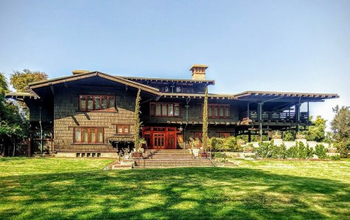 ★ Landmark
 ★ Landmark
 ★ Landmark


 c. 1875
 1879
 c. 1880
 c. 1880
 1880
 c. 1885
 c. 1885
 c. 1890
 c. 1890
 1890
 1890
 1890
 c. 1895
 1895
 1898
 1898
 1898
 1898
 1898
 1898
 1898
 1898
 1898
 1899
 c. 1900
 1900
 1900
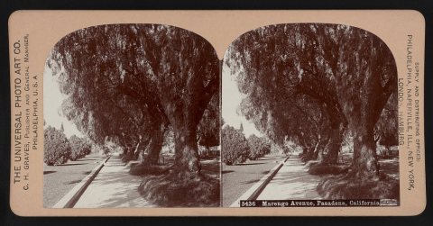 1900
 1900
 1900
 1901
 1903
 c. 1905
 1906


