Palo Alto’s post office opened in 1892, and 13% of its homes were built before 1940
More historic than 72% of U.S. towns · #47 of 847 in California. What drives it
19 places in town are on the National Register, among them five historic districts with 384 buildings between them. Below: 12 old photos and papers, maps from 1895 on, and the census since 1900.
The Palo Alto post office opened in 1892, the earliest record of the town by name. Wikidata gives 1894. Another post office, Mayfield (1855), opened inside today’s city and later closed.
First census: 1,658 in 19002020 census: 68,572134 years
How historic is Palo Alto?
B+
More historic than 72% of U.S. towns, on its age, its old homes and the National Register.
Founding year: the first Palo Alto post office (Blevins & Helbock, CC0). Wikidata: 1894.The full story ↓
History grade
What drives Palo Alto’s History grade
On its age, its old homes and the National Register, Palo Alto is more historic than 72% of U.S. towns, #47 of 847 in California. Its National Register listings hold the grade up; its age pulls it down.
B+
HistoryA character grade: shown, never part of Palo Alto’s overall grade.
Few California towns list much on the Register (a typical California town has 0.0 per 10,000 residents, the U.S. 2.4), so Palo Alto’s 60.4 sits above most of its state (98% of California towns have fewer) while its 406 historic buildings outnumber those of 96% of U.S. towns.
How sure. Graded on any two of the three inputs instead, the letter would range from C+ to A. The pre-1940 share (±1.2 points) is firm at this size. The founding year is the first post office, not a stated founding date; Wikidata’s 1894 falls in the same era, so the grade doesn’t depend on which one is used.
Founding year: the first post office (other dates in Quick answers). Homes: Census ACS 2020–24. National Register: National Park Service, May 2026 list; each listing counted once (boundary changes and added documentation belong to their listing), and a historic district counts its contributing buildings. How TownRatings grades history →
What stands out about Palo Alto’s past
Read from the archive, the National Register and the record. The page puts what stands out first.
Clarks LandinglocaleCrescent Park SchoolschoolCubberley High SchoolschoolLytton SchoolschoolMayfield High SchoolschoolNew Page Mill QuarriesmineOrtega SchoolschoolPalo Alto Military AcademyschoolVentura SchoolschoolVeterans Golf Courselocale
1cemetery inside Palo Alto
Alta Mesa
US Post Offices dataset (Blevins & Helbock, CC0). Places and cemeteries from the USGS Geographic Names Information System (2021).
Before the arrival of Europeans, the Ohlone lived on the San Francisco peninsula; in particular, the Puichon Ohlone lived in the Palo Alto area. The area of modern Palo Alto was first recorded by the 1769 party of Gaspar de Portolá, a 64-man, 200-horse expedition setting out from San Diego to find Monterey Bay. The group trekked past the bay without recognizing it and continued north. When they reached modern-day Pacifica, they ascended Sweeney Ridge and saw the San Francisco Bay on November 2. Portolá descended from Sweeney Ridge southeast down San Andreas Creek to Laguna Creek (now Crystal Springs Reservoir), thence to the San Francisquito Creek watershed, ultimately camping from November 6–11, 1769, by a tall redwood later to be known as El Palo Alto.
Passages that mention Palo Alto, cut from the printed page as they were published.
History of Santa Clara County, California, with biographical sketches of the leading men and women of the county who have been identified with its growth and development from the early days to the present1922Read the page →
Read the text
Mr. Peterson came to Palo Alto in 1901, soon after the town was started; he bought lots, built upon them, and contracted to haul sand and gravel from Mountain View to Palo Alto for the foundations of buildings at Palo Alto, among them the Nevada Building, the only building that escaped serious wreckage during the 1906 earthquake. He was elected president of the Teamsters' L'nion and was a
Text read by machine from the scan; it may contain errors.
History of Santa Clara County California1922 · page 1548Read the page →
Read the text
tered the court house. He put in about three years working in Montana, mostly at Butte, and four years in Arizona, then went to Oakland and came for the first time to Palo Alto in 1904; then he returned to Oakland and was there until 1906, when he returned to Palo Alto. He has practically done all the repair work in and about Palo Alto and much of the plaster work at the Stanford University. He is an expert
Text read by machine from the scan; it may contain errors.
History of Santa Clara County California1922 · page 428Read the page →
Read the text
Mr. Parkinson organized the Palo Alto Mutual Building and Loan Association, and became its first president. He also helped actively to establish the first newspaper in Palo Alto, the "Times," and afterwards himself owned the Palo Alto "Citizen," which in time was consolidated with the "Times." He owned the first water-works, supplied by two artesian wells, and before the town w'as incorporated, he laid four-
Text read by machine from the scan; it may contain errors.
Scans and text from the Internet Archive. Books published in 1930 or earlier, which are in the public domain.
Timeline
Palo Alto, 1855 to 1978
Woven from the archive, old maps, post office records, the National Register and the people born here.
Nothing in the archives for these yearsWeddings on Main Street, storms, parades, school pictures, the old store. If it’s in your family album, it belongs here.
Every edition of the U.S. Geological Survey’s map of Palo Alto. Tap a year, or press play to watch the town change.
1897Palo Alto sheet · 1:62,500
U.S. Geological Survey historical topographic maps (public domain), via Esri’s collection of the scans. The red ring marks the center of Palo Alto.
Every building
Palo Alto, building by building, 1895–1908
Fire insurance maps drew every building, what it was made of and what it was used for, so insurers could price the risk of fire. Pick a year, then a sheet.
The Palo Alto post office opened in 1892, the earliest record of the town by name (U.S. post office records). Wikidata gives 1894.
How does Palo Alto rank for history?
Palo Alto is more historic than 72% of U.S. towns, #47 of 847 in California. The History grade combines the town’s founding era, the share of homes built before 1940 and its National Register listings. It’s a character grade, so it isn’t part of the overall grade. How it works.
What is on the National Register in Palo Alto?
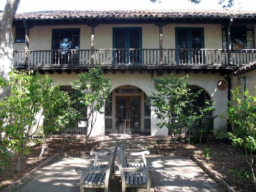
19 listings: 14 buildings, among them the John Adam Squire House (listed 1972, the first), and 5 historic districts with 384 contributing buildings. 406 historic buildings in all.
How old are the homes in Palo Alto?
13% of Palo Alto’s homes were built before 1940 (Census estimate, ±1.2 points), against a typical 3.4% for a California town; the median home was built in 1963.
Founding dates: Wikidata, Wikipedia, the U.S. post office records of Blevins & Helbock (CC0) and the Census. Homes by year built: Census ACS 2020–24. National Register of Historic Places: National Park Service (list of May 22, 2026). Old photos, postcards and papers: Wikimedia Commons, the Library of Congress and other public archives, credited on each item’s page. Maps: U.S. Geological Survey historical topographic maps (via Esri) and Sanborn fire-insurance maps (Library of Congress). History text and census tables: Wikipedia (CC BY-SA 4.0). Places that used to be: USGS Geographic Names Information System (2021).
From Wikimedia Commons (3), the Library of Congress (9), the National Register of Historic Places (19), Wikipedia, Wikidata and Wikipedia for famous people, U.S. Geological Survey historical maps, U.S. Census counts (via Wikipedia), the US Post Offices dataset (Blevins & Helbock), the USGS Geographic Names Information System, Sanborn fire insurance maps (Library of Congress) and old county and town histories (Internet Archive). Archive images are copied here with their credits and licenses, shown on each photo’s page. Refreshed monthly.


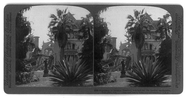


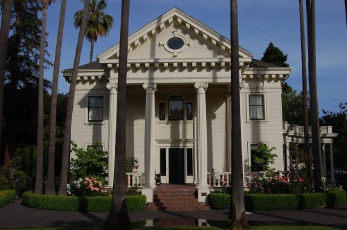


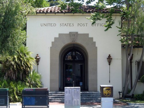





 1888
 1906
 1906
 1906
 1906
 1906
 1906
 1908


