Mountain View’s post office opened in 1854, and 2 of its places are on the National Register
More historic than 36% of U.S. towns · #269 of 847 in California. What drives it
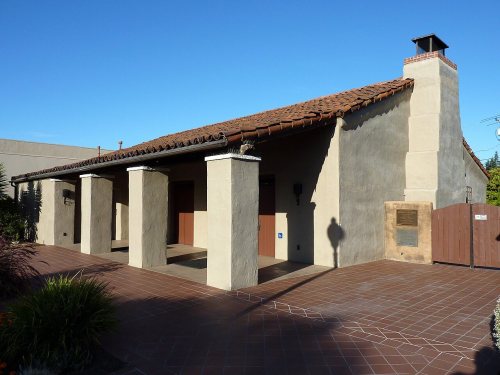
Most of Mountain View was built recently: 3% of its homes predate 1940 and the median home dates from 1975. Its Register listings are the Henry A. Rengstorff House and the Mountain View Adobe. Its Register listings are the Henry A. Rengstorff House and the Mountain View Adobe. Below: 2 old photos and papers, maps from 1888 on, and the census since 1880.
Founding year: the first Mountain View post office (Blevins & Helbock, CC0).The full story ↓
History grade
What drives Mountain View’s History grade
On its age, its old homes and the National Register, Mountain View is more historic than 36% of U.S. towns, #269 of 847 in California. Its National Register listings hold the grade up; its share of homes from before 1940 pulls it down.
C+
HistoryA character grade: shown, never part of Mountain View’s overall grade.
Few California towns list much on the Register (a typical California town has 0.0 per 10,000 residents, the U.S. 2.4), so Mountain View’s 0.2 sits above most of its state (66% of California towns have fewer) while its 2 listings outnumber those of 60% of U.S. towns.
How sure. Graded on any two of the three inputs instead, the letter would range from C− to B−. The pre-1940 share (±0.7 points) is firm at this size. The founding year is the first post office, not a stated founding date.
Founding year: the first post office (other dates in Quick answers). Homes: Census ACS 2020–24. National Register: National Park Service, May 2026 list; each listing counted once (boundary changes and added documentation belong to their listing), and a historic district counts its contributing buildings. How TownRatings grades history →
What stands out about Mountain View’s past
Read from the archive, the National Register and the record. The page puts what stands out first.
Mountain View’s post office has been open since 1854.
Hamlets and corners on the map
Blossom ValleyCastro CityCuernavacaCuesta ParkGemelloJackson ParkMonta LomaNew Frontier Mobile Home ParkRex ManorSahara Village Mobile Home ParkSaint Francis AcresSantiago Villa Mobile Home ParkSunset Estates Mobile Home ParkSylvan ParkThe CrossingsTravelodge Mobile Home ParkWaverly Park
Gone or out of use
First Presbyterian ChurchchurchIglesia MetodistachurchMission EvangelicachurchMountain View Grammar SchoolschoolMountain View High SchoolschoolWhisman Elementary Schoolschool
US Post Offices dataset (Blevins & Helbock, CC0). Places and cemeteries from the USGS Geographic Names Information System (2021).
Help out
Start Mountain View’s collection
The first neighbors to add old photos shape how Mountain View’s history is told.
Decades since 1900 with photos
00s10s20s30s40s50s60s70s80s90s
1 of 10 decades. The empty ones are waiting for someone’s album.
Every edition of the U.S. Geological Survey’s map of Mountain View. Tap a year, or press play to watch the town change.
1897Palo Alto sheet · 1:62,500
U.S. Geological Survey historical topographic maps (public domain), via Esri’s collection of the scans. The red ring marks the center of Mountain View.
The fertile land between the Santa Cruz Mountains and the shores of the southern San Francisco Bay once supported multiple villages of the indigenous Ohlone people. Spanish missionaries utilized the land for sheep pastures.
The Mexican land grant of Rancho Pastoria de las Borregas was given in 1842 by Alta California governor Juan Alvarado to Francisco Estrada. This grant was later passed on to Mariano Castro, who sold half of the land to Martin Murphy Jr. Eventually, the former land grant was developed as the cities of Mountain View and Sunnyvale.
Passages that mention Mountain View, cut from the printed page as they were published.
History of Santa Clara County California1922 · page 844Read the page →
Read the text
tism thus far demonstrated in the progressive programs of the institution, give a double assurance to patrons and public alike as to the present healthy state of the bank. Mountain View is justly proud of this institution and the bank looks proudly toward the city of Mountain View of tomorrow.
Text read by machine from the scan; it may contain errors.
History of Santa Clara County, California1881 · page 258Read the page →
Read the text
Virginia, and after enduring the many hardships consequent on crossing the plains at so eai'ly a date, settled about half a mile from where an inn was afterwards built and named the Fremont House, in 1847, not far from Mountain View. In the following year, 1848, his cousin, John Whisman, arrived on the scene, and located on the ground, a portion of which is now occupied by the depot of the Southern Pacific Railroad at Mountain View Station. To save confusion the last-named settler in after years became familiarly kncjw as " Old John." These and their families and one Creigh-
Text read by machine from the scan; it may contain errors.
History of Santa Clara County, California1881 · page 264Read the page →
Read the text
ment of the temporary, building which served as a depot, and the construction of the saloon of Shirley & Haines, which was purchased by the railroad for a station, the town may be said to have taken its start. This was the fir.st house in Mountain View Station. The next was the hotel, built in 1865 by Daniel Fiink and Shirley. It was originally used as a saloon, but afterwards added to until it assumed the proportions which it shows to-day. The thii-d house erected was that of Amos Neif, in the same year, on the site directly oppo.site the hotel, but the railroad afterwards acquiring
Text read by machine from the scan; it may contain errors.
History of Santa Clara County California1922 · page 299Read the page →
Read the text
The old town of Mountain View consisted of a stage station on the San Francisco road, built by James Campbell in 1852. The town was surveyed into lots and blocks by Frank Sleeper and Mariano Castro, but the town never evinced any dispositon to stray away from the one principal street. In 1869 S. P.
Text read by machine from the scan; it may contain errors.
Scans and text from the Internet Archive. Books published in 1930 or earlier, which are in the public domain.
Timeline
Mountain View, 1854 to 1998
Woven from the archive, old maps, post office records, the National Register and the people born here.
Nothing in the archives for these yearsWeddings on Main Street, storms, parades, school pictures, the old store. If it’s in your family album, it belongs here.
Fire insurance maps drew every building, what it was made of and what it was used for, so insurers could price the risk of fire. Pick a year, then a sheet.
1888Sheet 1 of 1
Edition
Sheets
BrickWoodStone
Sanborn Map Company, via the Library of Congress. Editions published in 1930 or earlier, which are in the public domain.
Then & now
Stand where they stood
No then-and-now pairs yet. Take a photo from the same spot as an old one and they appear here side by side.
Retake this viewMountain View, California. Farm house in rural section where farmers of Japanese ancestry raised tr, 1942
Find the spot, match the angle, and add your photo. It becomes the first then-and-now pair on Mountain View’s page.
The Mountain View post office opened in 1854, the earliest record of the town by name (U.S. post office records).
How does Mountain View rank for history?
Mountain View is more historic than 36% of U.S. towns, #269 of 847 in California. The History grade combines the town’s founding era, the share of homes built before 1940 and its National Register listings. It’s a character grade, so it isn’t part of the overall grade. How it works.
What is on the National Register in Mountain View?
Two places: the Henry A. Rengstorff House (listed 1978) and the Mountain View Adobe (2002).
How old are the homes in Mountain View?
3% of Mountain View’s homes were built before 1940 (Census estimate), against a typical 3.4% for a California town; the median home was built in 1975.
Founding dates: Wikidata, Wikipedia, the U.S. post office records of Blevins & Helbock (CC0) and the Census. Homes by year built: Census ACS 2020–24. National Register of Historic Places: National Park Service (list of May 22, 2026). Old photos, postcards and papers: Wikimedia Commons, the Library of Congress and other public archives, credited on each item’s page. Maps: U.S. Geological Survey historical topographic maps (via Esri) and Sanborn fire-insurance maps (Library of Congress). History text and census tables: Wikipedia (CC BY-SA 4.0). Places that used to be: USGS Geographic Names Information System (2021).
From Wikimedia Commons (13), the Library of Congress (5), the National Register of Historic Places (2), Wikipedia, Wikidata and Wikipedia for famous people, U.S. Geological Survey historical maps, U.S. Census counts (via Wikipedia), the US Post Offices dataset (Blevins & Helbock), the USGS Geographic Names Information System, Sanborn fire insurance maps (Library of Congress) and old county and town histories (Internet Archive). Archive images are copied here with their credits and licenses, shown on each photo’s page. Refreshed monthly.


 1942
 2025
 2020
 2020
 2019
 2018
 2017
 2014
 2014
 2013
 2012
 2012
 2012
 2012
 2012
 2012
 2005