Schools are its strong suit (A+). It also does well on health (A+). The drawback is cost of living (D−): the typical home is worth about $2.2 million, 19.2 years of the Seattle metro’s $115K median household income. Put together, the subjects come to an A overall, better than 92% of U.S. towns. That places it 6th of 285 in Washington. On the outdoors, just 37 of Washington’s 397 towns do better. Just over four in five adults 25 and older hold a bachelor’s degree or more in Mercer Island, where Washington’s towns sit at 30% and U.S. towns at 29%. This Washington town is easier to get around on foot or by transit than 95% of U.S. towns.
Figures: schools, state test and graduation results · health, CDC PLACES · home values, Zillow · incomes, Census ACS, 2020–24 · USGS PAD-US.
Mercer Island is the healthiest town in Washington, fares better on crime within Washington than nationally and has schools in the top 5% of Washington.
At 19.2 years of the Seattle metro’s $115K median household income, the typical home (about $2.21M) costs more against local pay than in 99% of Washington towns; that ratio is one input to that grade. The typical value, about $2.21M, is 8% below its June 2022 peak.
Homes sold in Mercer Island spent a median 11 days on the market. Its median rent stands at $2,502 a month. Sellers in Mercer Island got 98.4% of the asking price, typically.
Its A+ ranks #1 of the 285 Washington towns we grade for schools. Its A+ for schools comes with a D− for cost of living: the typical home is worth about $2.21M.
The Mercer Island School District runs its public schools. Two of the 13 schools are below, and why each made the list. 4 public schools serve Mercer Island, with 1,594 students in all.
It is the healthiest of the 285 Washington towns we grade on the CDC estimates behind the Health Grade. Its widest gap with Washington is tooth loss: 3.9% of those 65+ have lost all their teeth, against 9% statewide.
Among 285 Washington towns, just 3 have a lower share of adults who report frequent mental distress than Mercer Island. 7.4% of adults have diabetes locally. Also worth knowing: on the CDC’s 31 measures, Mercer Island is ahead of Washington on 27 and behind on 2.
99%healthier than U.S. townsA+Health Grade
Mercer Island
Washington towns
U.S. towns
Obesity (CDC PLACES)
20%
33%
35%
Frequent mental distress (CDC PLACES)
12%
17%
17%
Sleep under 7 hours (CDC PLACES)
26%
33%
36%
Smoke cigarettes (CDC PLACES)
4.9%
11%
14%
31 measures vs. Washington
27 better2 too close to call2 worse
What stands out
Mercer Island
WA
Fewer older adults who have lost all their teeth
3.9%
9%
Fewer adults facing a utility shut-off
2.4%
5.1%
More adults who have had cancer
9.5%
7.9%
Seattle VA Medical Center (VA Puget Sound Healthcare System)
The biggest place to walk is Pioneer Park, 120 acres with 5.9 miles of trail. Across 19 parks and preserves: 18 miles of trail. Mercer Island’s concentration of trails comes in at 1.4 miles per square mile.
38.6% of workers work from home, against 19.8% across Washington.
Most people who work leave Mercer Island to do it: just 7% work in town. Among residents locally, 3.8% live below the poverty line. This Washington town had 7,145 jobs in 2023, up 1,160 from 2013. The median commute is under 6 miles.
7%work in town
Mercer Island
Washington towns
U.S. towns
Work from home
39%
15%
11%
Median household income
$219,000
$98,000
$80,000
Below the poverty line
3.8%
7.9%
9.6%
Average trip to work
24 minutes
27 minutes
25 minutes
Where working residents work
In Mercer Island7%
Seattle42%
Bellevue12%
Redmond7%
Renton3%
6 mi
median commute distance
7,145
jobs based in Mercer Island
A commuter town
jobs vs. working residents
A
Walkability grade: more walkable than 95% of U.S. towns
In Mercer Island, the FEMA hazard score is 68 of 100. The national flood insurance program has paid 4 claims locally since 2006. FEMA puts just over two thirds of the town’s expected hazard losses down to earthquakes, and 30% to inland flooding. Federal disaster aid has reached households in Mercer Island after 9 declared disasters, most recently in 2025.
July afternoons average 77.2°, cooler than in 97% of U.S. towns; January nights average 36.7°.
For Mercer Island, the midsummer high is 77°F. Only 7 of the 285 Washington towns we compare have a higher January low than Mercer Island. About 4 inches of snow falls in a winter.
At 13.5 crimes per 1,000 residents a year, it reports less crime than 87% of Washington’s graded towns. Violent crime is rare: 17 reported in 2025, 0.7 per 1,000 residents.
The violent crime rate in Mercer Island is 0.7 per 1,000 residents. The rate of thefts and burglaries locally is 9.5 per 1,000 residents.
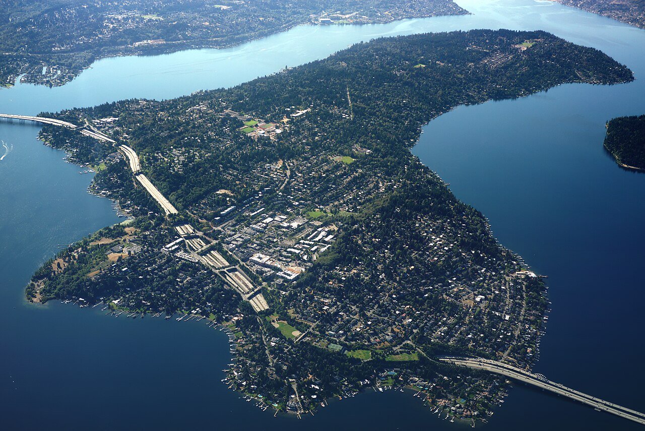
Mercer Island is a city in King County, Washington, United States, located on an island of the same name in the southern portion of Lake Washington. Mercer Island is in the Seattle metropolitan area, connected to the mainland on both sides by bridges carrying Interstate 90 and Link light rail, with the city of Seattle to the west and the city of Bellevue to the east. The population was 25,748 at the 2020 census. Mercer Island is one of the 100 richest ZIP codes in the US, according to the IRS figures for adjusted gross income.
Yes, by almost any measure. Mercer Island grades A overall, better than 92% of U.S. towns and #6 of 285 in Washington. It grades A+ for health, B for safety and A+ for schools. Cost of living is its weak spot, with a D−.
Are Mercer Island schools good?
Yes. The public schools Mercer Island children attend outperform 100% of Washington districts on state tests and graduation, an A+ School Grade.
Is Mercer Island, WA expensive?
Yes. Cost of living, which also weighs rents, property taxes and how many households pay 30% or more of their income for housing, grades D−.
What is Mercer Island, WA known for?
5 notable people were born here, including Mary Wayte and Quin Snyder.




 5 mi
 6 mi
 7 mi


