Vergennes dates to 1766, and 33% of its homes were built before 1940
Among the most historic 1% of U.S. towns · #5 of 71 in Vermont. What drives it
5 places in town are on the National Register, among them two historic districts with 169 buildings between them. Below: 5 old photos and papers, maps from 1885 on, and the census since 1790.
Founding year: Wikipedia. First post office: 1793.The full story ↓
History grade
What drives Vergennes’ History grade
On its age, its old homes and the National Register, Vergennes is among the most historic 1% of U.S. towns, #5 of 71 in Vermont. All 3 inputs put Vergennes near the top nationally; its age ranks highest.
A+
HistoryA character grade: shown, never part of Vergennes’ overall grade.
Vermont towns list more on the Register than most of the country (a typical Vermont town has 147 per 10,000 residents, the U.S. 2.4), so Vergennes’ 671 sits above most of its state (91% of Vermont towns have fewer) while its 172 historic buildings outnumber those of 92% of U.S. towns.
How sure. Graded on any two of the three inputs instead, the letter would still be A+. The pre-1940 share is a Census survey estimate (±5.9 points). Two sources give 1766.
Founding year: Wikipedia (other dates in Quick answers). Homes: Census ACS 2020–24. National Register: National Park Service, May 2026 list; each listing counted once (boundary changes and added documentation belong to their listing), and a historic district counts its contributing buildings. How TownRatings grades history →
What stands out about Vergennes’ past
Read from the archive, the National Register and the record. The page puts what stands out first.
National Park Service, National Register of Historic Places. Photos from Wikimedia Commons, credited on each place’s page.
Every building
Vergennes, building by building, 1885–1920
Fire insurance maps drew every building, what it was made of and what it was used for, so insurers could price the risk of fire. Pick a year, then a sheet.
Vergennes was settled in 1766 by Donald MacIntosh. It was established as a city in 1788, the only one in Vermont not to have been first chartered as a town or independent village. Instead, intersecting portions of the pre-existing towns of New Haven, Panton, and Ferrisburg at the Otter Creek Falls were combined to form Vergennes. It is the smallest city by population in Vermont.
The city is named for Frenchman Charles Gravier, comte de Vergennes, who greatly aided the rebel colonial effort in the American Revolutionary War.
Passages that mention Vergennes, cut from the printed page as they were published.
History of Addison county Vermont, with illustrations and biographical sketches of some of its prominent men and pioneers1886 · page 66Read the page →
Read the text
properly said to constitute a part of the history of Addison county. Only a few permanent settlements had been made within its limits. " It is said that James Mcintosh, a Scotchman, commenced settlement in territory now a part of the city of Vergennes, in the year 1766; and other settlements were made on the creek above the falls in New Haven, now Waltham, as early as 1769. Colonel John Chipman in 1766 made a small clearing on his farm in Middlebury, but did not return to it with his family until 1773 ; and in the latter year several other families were settled in that town. It is said that in the charter
Text read by machine from the scan; it may contain errors.
History of Addison county Vermont, with illustrations and biographical sketches of some of its prominent men and pioneers1886 · page 526Read the page →
Read the text
This town has undergone several changes. October 29, 1789, a tract of land on the north called New Haven Gore was annexed to it, and October 29, 1 79 1, a part of the town was annexed to Weybridge. October 23, 1783, a corner was taken to aid in the incorporation of the city of Vergennes, a portion of which, together with a part of Addison and this town, were in November, 1796, taken to form the town of Waltham.
Text read by machine from the scan; it may contain errors.
Scans and text from the Internet Archive. Books published in 1930 or earlier, which are in the public domain.
By decade
Vergennes, decade by decade
3 decades in the archive, from the 1810s to the 1890s. Scroll each row; tap a photo for its story.
Nothing in the archives for these yearsWeddings on Main Street, storms, parades, school pictures, the old store. If it’s in your family album, it belongs here.
In 1766, according to Wikipedia’s history of the town. Vergennes’ post office opened in 1793, and the first U.S. census counted 201 people here in 1790.
How does Vergennes rank for history?
Vergennes is among the most historic 1% of U.S. towns, #5 of 71 in Vermont. The History grade combines the town’s founding era, the share of homes built before 1940 and its National Register listings. It’s a character grade, so it isn’t part of the overall grade. How it works.
What is on the National Register in Vergennes?
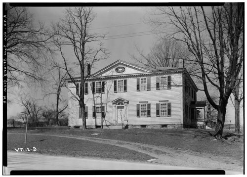
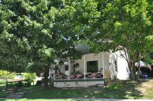
5 listings: 3 buildings, among them the Gen. Samuel Strong House (listed 1973, the first), and 2 historic districts, the Vergennes Historic District and the Vergennes Residential Historic District, with 169 contributing buildings. 172 historic buildings in all.
How old are the homes in Vergennes?
33% of Vergennes’ homes were built before 1940 (Census estimate, ±5.9 points), against a typical 22% for a Vermont town; the median home was built in 1967.
Founding dates: Wikidata, Wikipedia, the U.S. post office records of Blevins & Helbock (CC0) and the Census. Homes by year built: Census ACS 2020–24. National Register of Historic Places: National Park Service (list of May 22, 2026). Old photos, postcards and papers: Wikimedia Commons, the Library of Congress and other public archives, credited on each item’s page. Maps: U.S. Geological Survey historical topographic maps (via Esri) and Sanborn fire-insurance maps (Library of Congress). History text and census tables: Wikipedia (CC BY-SA 4.0). Places that used to be: USGS Geographic Names Information System (2021).
From Wikimedia Commons (5), Wikidata (1), the National Register of Historic Places (5), Wikipedia, Wikidata and Wikipedia for famous people, U.S. Geological Survey historical maps, U.S. Census counts (via Wikipedia), the US Post Offices dataset (Blevins & Helbock), the USGS Geographic Names Information System, Sanborn fire insurance maps (Library of Congress) and old county and town histories (Internet Archive). Archive images are copied here with their credits and licenses, shown on each photo’s page. Refreshed monthly.








 c. 1875
 1890

