3 places in town are on the National Register, among them a historic district with 73 buildings. Below: 4 old photos and papers, maps from 1891 on, and the census since 1790.
Founding year: Wikidata. First post office: 1811.The full story ↓
History grade
What drives Newfane’s History grade
On its age, its old homes and the National Register, Newfane is more historic than 97% of U.S. towns. All 3 inputs are above most U.S. towns; its age ranks highest and its share of homes from before 1940 lowest.
A+
HistoryA character grade: shown, never part of Newfane’s overall grade.
Vermont towns list more on the Register than most of the country (a typical Vermont town has 147 per 10,000 residents, the U.S. 2.4), so Newfane’s 501 sits above most of its state (84% of Vermont towns have fewer) while its 73 historic buildings outnumber those of 87% of U.S. towns.
How sure. Graded on any two of the three inputs instead, the letter would range from A to A+. The pre-1940 share is a Census survey estimate (±6.4 points). Two sources give 1761.
Founding year: Wikidata (other dates in Quick answers). Homes: Census ACS 2020–24. National Register: National Park Service, May 2026 list; each listing counted once (boundary changes and added documentation belong to their listing), and a historic district counts its contributing buildings. How TownRatings grades history →
What stands out about Newfane’s past
Read from the archive, the National Register and the record. The page puts what stands out first.
One of the New Hampshire grants, the town was chartered on June 19, 1753, by Governor Benning Wentworth, who named it Fane after John Fane, the 7th Earl of Westmoreland. But hostilities during the French and Indian War prevented its settlement. Because a first town meeting was not held within the required five years, the charter was deemed null and void. So Wentworth issued an entirely new charter on November 3, 1761, as New Fane. The town was settled in 1766 by families from Worcester County, Massachusetts. Newfane became the shire town of the county before 1812. A village was built atop Newfane Hill, including the county buildings. But because of winter travel difficulties, it was relocated to the flatland below in 1825, until 1882 called Fayetteville after the Marquis de Lafayette.
Passages that mention Newfane, cut from the printed page as they were published.
Centennial proceedings and other historical facts and incidents relating to Newfane, the county seat of Windham County, Vermont1877Read the page →
Read the text
was liberal and generous to the poor, entered heartily and zealously into all the public enterprises of the day, gave to the County of Windham the land for a common on Newfane hill, at the time of the removal of the shire from Westminster to Newfane, and contributed largely towards the erection of the first Court House and Jail in Newfane.
Text read by machine from the scan; it may contain errors.
Centennial proceedings and other historical facts and incidents relating to Newfane, the county seat of Windham County, Vermont1877 · page 92Read the page →
Read the text
New Testament — beloved by all his brethren and friends, and respected by all his acquaintances. His standing may be known from the fact that for four years he represented the town of Newfane in the Legislature of Vermont, and was twenty-nine consecutive years elected Town Clerk, and held the office at the time of his death. A great concourse of
Text read by machine from the scan; it may contain errors.
Scans and text from the Internet Archive. Books published in 1930 or earlier, which are in the public domain.
Timeline
Newfane, 1761 to 2010
Woven from the archive, old maps, post office records, the National Register and the people born here.
Nothing in the archives for these yearsWeddings on Main Street, storms, parades, school pictures, the old store. If it’s in your family album, it belongs here.
In 1761, according to Wikidata. Newfane’s post office opened in 1811, and the first U.S. census counted 660 people here in 1790.
How does Newfane rank for history?
Newfane is more historic than 97% of U.S. towns. The History grade combines the town’s founding era, the share of homes built before 1940 and its National Register listings. It’s a character grade, so it isn’t part of the overall grade. How it works.
What is on the National Register in Newfane?
Three places: the Williamsville Covered Bridge (listed 1973), the Newfane Village Historic District (1983) and the South Newfane Bridge (1992).
How old are the homes in Newfane?
24% of Newfane’s homes were built before 1940 (Census estimate, ±6.4 points), against a typical 22% for a Vermont town; the median home was built in 1971.
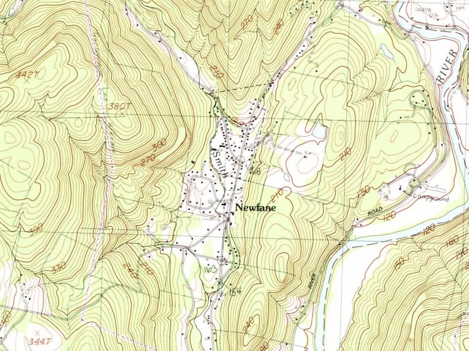
Founding dates: Wikidata, Wikipedia, the U.S. post office records of Blevins & Helbock (CC0) and the Census. Homes by year built: Census ACS 2020–24. National Register of Historic Places: National Park Service (list of May 22, 2026). Old photos, postcards and papers: Wikimedia Commons, the Library of Congress and other public archives, credited on each item’s page. Maps: U.S. Geological Survey historical topographic maps (via Esri) and Sanborn fire-insurance maps (Library of Congress). History text and census tables: Wikipedia (CC BY-SA 4.0). Places that used to be: USGS Geographic Names Information System (2021).
From Wikimedia Commons (6), the Library of Congress (1), Wikidata (3), the National Register of Historic Places (3), Wikipedia, Wikidata and Wikipedia for famous people, U.S. Geological Survey historical maps, U.S. Census counts (via Wikipedia), the US Post Offices dataset (Blevins & Helbock), the USGS Geographic Names Information System and old county and town histories (Internet Archive). Archive images are copied here with their credits and licenses, shown on each photo’s page. Refreshed monthly.




 1909
 Date?
 2016
 2008
 2004


