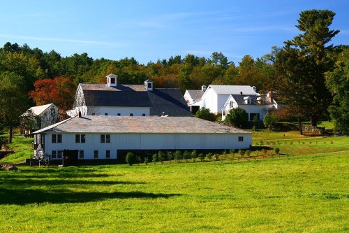
4 places in town are on the National Register, among them the Naulakha, a National Historic Landmark, and a historic district with 16 buildings. Below: 3 old photos and papers, maps from 1891 on, and the census since 1790.
The Dummerston post office opened in 1815, the earliest record of the town by name. Three smaller post offices, East Dummerston (1886), Slab Hollow (1886) and Dummerston Station (1908), opened inside today’s town and later closed.
First census: 1,501 in 17902020 census: 1,865211 years
How historic is Dummerston?
A−
More historic than 80% of U.S. towns, on its age, its old homes and the National Register.
Founding year: the first Dummerston post office (Blevins & Helbock, CC0).The full story ↓
History grade
What drives Dummerston’s History grade
On its age, its old homes and the National Register, Dummerston is more historic than 80% of U.S. towns. All 3 inputs are above most U.S. towns; its age ranks highest and its share of homes from before 1940 lowest.
A−
HistoryA character grade: shown, never part of Dummerston’s overall grade.
Vermont towns list more on the Register than most of the country (a typical Vermont town has 147 per 10,000 residents, the U.S. 2.4), so Dummerston’s 95.7 sits near the middle of its state (57% of Vermont towns have fewer) while its 20 historic buildings outnumber those of 79% of U.S. towns.
How sure. Graded on any two of the three inputs instead, the letter would range from B+ to A−. The pre-1940 share is a Census survey estimate (±5.3 points). The founding year is the first post office, not a stated founding date.
Founding year: the first post office (other dates in Quick answers). Homes: Census ACS 2020–24. National Register: National Park Service, May 2026 list; each listing counted once (boundary changes and added documentation belong to their listing), and a historic district counts its contributing buildings. How TownRatings grades history →
What stands out about Dummerston’s past
Read from the archive, the National Register and the record. The page puts what stands out first.
Dummerston was part of the Equivalent Lands—several large sections of land given to settlers in the early eighteenth century. It lies on a tract given to the Connecticut Colony about 1715 by the Province of Massachusetts Bay as compensation for land mistakenly awarded by the latter to its settlers. In 1716, the town was auctioned to a consortium (which included William Dummer, lieutenant governor of Massachusetts), and named Dummerston. On December 26, 1753, the town was chartered as a New Hampshire grant and renamed Fulham by Governor Benning Wentworth. But when the grant was renegotiated, it reverted to Dummerston.
Passages that mention Dummerston, cut from the printed page as they were published.
The history of the town of Dummerston1884 · page 210Read the page →
Read the text
Th\b mem(-rial was erected by her son.'* CAPT. EZEKIEL WILSON Was the ancestor of the Wilson families that settled in Dummerston. He was one of the first settlers on Putney West Hill, but living very near to Dummerston line, was much associated with the affairs in the west part of this town
Text read by machine from the scan; it may contain errors.
The history of the town of Dummerston1884 · page 49Read the page →
Read the text
The original survey parchment of the town of Dummerston, made in 1767, is signed by Ebenezer Waters. Nearly all the parchment is much faded. Probably Isaac Miller was one of the company who made the survey, as he was employed that year by the heirs of the late Gov. Dummer to lay out the town-
Text read by machine from the scan; it may contain errors.
Scans and text from the Internet Archive. Books published in 1930 or earlier, which are in the public domain.
Timeline
Dummerston, 1808 to 2000
Woven from the archive, old maps, post office records, the National Register and the people born here.
Nothing in the archives for these yearsWeddings on Main Street, storms, parades, school pictures, the old store. If it’s in your family album, it belongs here.
The Dummerston post office opened in 1815, the earliest record of the town by name (U.S. post office records).
How does Dummerston rank for history?
Dummerston is more historic than 80% of U.S. towns. The History grade combines the town’s founding era, the share of homes built before 1940 and its National Register listings. It’s a character grade, so it isn’t part of the overall grade. How it works.
What is on the National Register in Dummerston?
4 listings: 1 building, among them the Naulakha (a National Historic Landmark since 1993), 1 historic district, the Scott Farm Historic District, with 16 contributing buildings, and 2 structures. 20 historic buildings in all.
How old are the homes in Dummerston?
16% of Dummerston’s homes were built before 1940 (Census estimate, ±5.3 points), against a typical 22% for a Vermont town; the median home was built in 1971.
Founding dates: Wikidata, Wikipedia, the U.S. post office records of Blevins & Helbock (CC0) and the Census. Homes by year built: Census ACS 2020–24. National Register of Historic Places: National Park Service (list of May 22, 2026). Old photos, postcards and papers: Wikimedia Commons, the Library of Congress and other public archives, credited on each item’s page. Maps: U.S. Geological Survey historical topographic maps (via Esri) and Sanborn fire-insurance maps (Library of Congress). History text and census tables: Wikipedia (CC BY-SA 4.0). Places that used to be: USGS Geographic Names Information System (2021).
From Wikimedia Commons (2), the Library of Congress (1), Wikidata (3), the National Register of Historic Places (4), Wikipedia, Wikidata and Wikipedia for famous people, U.S. Geological Survey historical maps, U.S. Census counts (via Wikipedia), the US Post Offices dataset (Blevins & Helbock), the USGS Geographic Names Information System and old county and town histories (Internet Archive). Archive images are copied here with their credits and licenses, shown on each photo’s page. Refreshed monthly.