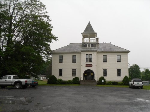
Castleton dates to 1761, and 17% of its homes were built before 1940
More historic than 92% of U.S. towns · #33 of 71 in Vermont. What drives it
4 places in town are on the National Register, among them a historic district with 87 buildings. Below: 27 old photos and papers, maps from 1895 on, and the census since 1790.
Founding year: Wikidata. First post office: 1805.The full story ↓
History grade
What drives Castleton’s History grade
On its age, its old homes and the National Register, Castleton is more historic than 92% of U.S. towns, #33 of 71 in Vermont. All 3 inputs are above most U.S. towns; its age ranks highest and its share of homes from before 1940 lowest.
A
HistoryA character grade: shown, never part of Castleton’s overall grade.
Vermont towns list more on the Register than most of the country (a typical Vermont town has 147 per 10,000 residents, the U.S. 2.4), so Castleton’s 202 sits above most of its state (69% of Vermont towns have fewer) while its 90 historic buildings outnumber those of 89% of U.S. towns.
How sure. Graded on any two of the three inputs instead, the letter would range from A− to A+. The pre-1940 share is a Census survey estimate (±6.8 points). Two sources give 1761.
Founding year: Wikidata (other dates in Quick answers). Homes: Census ACS 2020–24. National Register: National Park Service, May 2026 list; each listing counted once (boundary changes and added documentation belong to their listing), and a historic district counts its contributing buildings. How TownRatings grades history →
What stands out about Castleton’s past
Read from the archive, the National Register and the record. The page puts what stands out first.
Nothing in the archives for these yearsWeddings on Main Street, storms, parades, school pictures, the old store. If it’s in your family album, it belongs here.
Nothing in the archives for these yearsWeddings on Main Street, storms, parades, school pictures, the old store. If it’s in your family album, it belongs here.
Castleton was settled in 1770 and chartered in 1761. The charter for 36 square miles (93 km2) of land was granted by Governor Benning Wentworth of New Hampshire and divided the land into 70 "rights" or "shares". Governor Wentworth retained ownership of two shares, and several others were given for churches and a school.
Lawful money, to defray the expense that has' already arisen, or that shall arise, in laying out the Township of Castleton, and in cutting a ro'id through the woods from Wood- (. 'reek to Castleton, and other incidental charges that may arise."
Text read by machine from the scan; it may contain errors.
History of Rutland County, Vermont, with illustrations and biographical sketches of some of its prominent men and pioneers1886 · page 517Read the page →
Read the text
In 1769 Colonel Bird, according to probable inference, returned to Castleton and built the house which he afterwards occupied, on the bank of Castleton River, near its junction with the old turnpike. The last proprietors' meeting held in Salisbury, on the 27th of February, 1770, was "adjourned to be held at the house of Colonel Amos Bird, in Castleton, the 27th day of May next, at two o'clock, p. m." Colonels Bird and Lee were both present at this meeting and assisted in making arrangements for the settlement of their town in the following spring. In pursuance of these arrangements, Ephraim Buel, Eben-
Text read by machine from the scan; it may contain errors.
History of Rutland County, Vermont, with illustrations and biographical sketches of some of its prominent men and pioneers1886 · page 518Read the page →
Read the text
This little community soon assumed an organized form, and began improving their environments, clearing forests, cultivating fields, building bridges, opening roads, etc. A road from the west line of Ira to the town of Fairhaven was surveyed in 1772, following the course of Castleton River, which passes southerly from its source in Pittsford, receives a tributary in West Rutland, and flowing westerly, divides Castleton into two nearly equal parts. The western part of this road was afterward changed so as to run from Castleton Corners to Hydeville. A north and south road from Hubbardton to East Poult-
Text read by machine from the scan; it may contain errors.
Scans and text from the Internet Archive. Books published in 1930 or earlier, which are in the public domain.
Timeline
Castleton, 1761 to 2010
Woven from the archive, old maps, post office records, the National Register and the people born here.
In 1761, according to Wikidata. Castleton’s post office opened in 1805, and the first U.S. census counted 800 people here in 1790.
How does Castleton rank for history?
Castleton is more historic than 92% of U.S. towns, #33 of 71 in Vermont. The History grade combines the town’s founding era, the share of homes built before 1940 and its National Register listings. It’s a character grade, so it isn’t part of the overall grade. How it works.
What is on the National Register in Castleton?
4 listings: 3 buildings, among them the Castleton Medical College Building (listed 1971, the first), and 1 historic district, the Castleton Village Historic District, with 87 contributing buildings. 90 historic buildings in all.
How old are the homes in Castleton?
17% of Castleton’s homes were built before 1940 (Census estimate, ±6.8 points), against a typical 22% for a Vermont town; the median home was built in 1974.
Founding dates: Wikidata, Wikipedia, the U.S. post office records of Blevins & Helbock (CC0) and the Census. Homes by year built: Census ACS 2020–24. National Register of Historic Places: National Park Service (list of May 22, 2026). Old photos, postcards and papers: Wikimedia Commons, the Library of Congress and other public archives, credited on each item’s page. Maps: U.S. Geological Survey historical topographic maps (via Esri) and Sanborn fire-insurance maps (Library of Congress). History text and census tables: Wikipedia (CC BY-SA 4.0). Places that used to be: USGS Geographic Names Information System (2021).
From Wikimedia Commons (5), the Library of Congress (24), Wikidata (1), the National Register of Historic Places (4), Wikipedia, Wikidata and Wikipedia for famous people, U.S. Geological Survey historical maps, U.S. Census counts (via Wikipedia), the US Post Offices dataset (Blevins & Helbock), the USGS Geographic Names Information System and old county and town histories (Internet Archive). Archive images are copied here with their credits and licenses, shown on each photo’s page. Refreshed monthly.


 1898
 1898
 1900
 1905
 1905
 1941
 1941
 1941
 1941
 1941
 1941
 1941
 1941
 1941
 1941
 1941
 1941
 1941
 1941
 1941
 1941
 1941
 1941
 1941
 1941
 1941
 1941
 2007
 2006