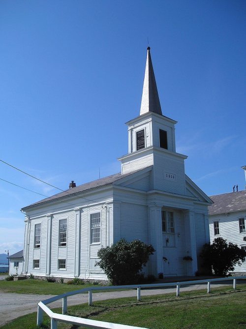
The story
Read it all →How Addison came to be
From Wikipedia’s history of Addison.
Addison was chartered on October 14, 1761. Benning Wentworth named the town Addison after poet Joseph Addison.
Text from Wikipedia, licensed CC BY-SA 4.0.
Each edition grades its towns against each other only.
More historic than 88% of U.S. towns. What drives it
4 places in town are on the National Register. Below: 1 old photo or paper, maps from 1945 on, and the census since 1790.
Addison dates its founding to 1761 (Wikidata and Wikipedia’s history agree). It appears in the first U.S. census, 1790.
More historic than 88% of U.S. towns, on its age, its old homes and the National Register.
On its age, its old homes and the National Register, Addison is more historic than 88% of U.S. towns. All 3 inputs are above most U.S. towns; its age ranks highest and its National Register listings lowest.
Vermont towns list more on the Register than most of the country (a typical Vermont town has 147 per 10,000 residents, the U.S. 2.4), so Addison’s 34.0 sits near the middle of its state (43% of Vermont towns have fewer) while its 4 listings outnumber those of 68% of U.S. towns.
Founding year: Wikidata (other dates in Quick answers). Homes: Census ACS 2020–24. National Register: National Park Service, May 2026 list; each listing counted once (boundary changes and added documentation belong to their listing), and a historic district counts its contributing buildings. How TownRatings grades history →
Read from the archive, the National Register and the record. The page puts what stands out first.
The first neighbors to add old photos shape how Addison’s history is told.
Lost half of its people between 1830 and 1940, then more than doubled.
24 censuses, 1790–2020.
U.S. Census Bureau decennial counts, from the census table on Addison’s Wikipedia page.
Addison had its own post office from 1798 to 1902. Two other post offices opened and closed inside today’s town.
US Post Offices dataset (Blevins & Helbock, CC0). Places and cemeteries from the USGS Geographic Names Information System (2021).
From Wikipedia’s history of Addison.
Addison was chartered on October 14, 1761. Benning Wentworth named the town Addison after poet Joseph Addison.
Text from Wikipedia, licensed CC BY-SA 4.0.
Passages that mention Addison, cut from the printed page as they were published.

The first settlement hj Europeans in the County of Addison, was made bj the French, on the east shore of Lake Champlain. opposite Crown Point, in pursuance of their .plan to extend theii settlements, and fortifications, and set limits to those of the English. In the year 1730, a few individuals or families, came up the lake from Canada, and established themselves at Chimncj Point, in Addison, and built a block house and windmill, on the point where the tavern house now stands. The next year troops were sent out and
Text read by machine from the scan; it may contain errors.
In 1770 began the charter difficulties with the town of Addison, of which Judge Smith writes as follows: " These difficulties continued till an agreement was ratified, May 17, 1774, by which Addison held according to her charter: but gave 8,000 acres of the disputed territory to the Panton proprietors 'for a reward for duties done in settling s'd tract,' which was defined and ratified at the first meeting held after the Revolutionary War, at Pawlet. This agreement left 115 acres of Panton territory, lying on Otter Creek, near Reef Bridge, detached from the rest of the town, and long known as 'Little Panton,' which was
Text read by machine from the scan; it may contain errors.
At about the time Addison was chartered, Panton also was granted to the first proprietors. But the grant as defined extended over the northern boundary of the town of Addison about four miles along the lake ; hence some of the first settlers of this town supposed they were locating in Panton. This state of affairs led to protracted trouble and litigation between the two towns, which was not finally settled until May 17, 1774; Addison held her territory according to her charter, by right of priority of grant ; but she gave up to Panton 8,000 acres of the disputed territory, "for a reward for duties done in
Text read by machine from the scan; it may contain errors.
cation for them, and soon extended over nearly the whole territory chartered by New Hampshire. The valleys of Lake Champlain and Otter Creek, were granted principally to reduced officers, and a large territory, north of Addison Count}*, was reserved for noncommissioned officers and soldiers. A small tract was also reserved for them in the County of Addison, near the bend of the creek in Weybridge and New Haven, and perhaps some contiguous territory.
Text read by machine from the scan; it may contain errors.Scans and text from the Internet Archive. Books published in 1930 or earlier, which are in the public domain.
Woven from the archive, old maps, post office records, the National Register and the people born here.
 BuiltJohn Strong House is built
 In the archiveChurch and grange. Addison, Vermont, by Louise Rosskam, United States Office of War Infor…
 On the mapFirst mapped by the U.S. Geological Survey
One decade in the archive so far: the 1940s. Scroll each row; tap a photo for its story.
Every edition of the U.S. Geological Survey’s map of Addison. Tap a year, or press play to watch the town change.
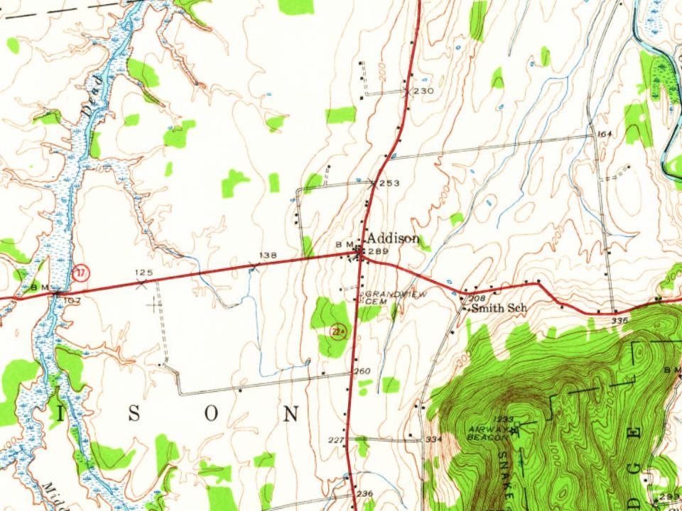
U.S. Geological Survey historical topographic maps (public domain), via Esri’s collection of the scans. The red ring marks the center of Addison.
No then-and-now pairs yet. Take a photo from the same spot as an old one and they appear here side by side.

Find the spot, match the angle, and add your photo. It becomes the first then-and-now pair on Addison’s page.
Retake this view · +15The country’s official list of buildings and places worth saving.
National Park Service, National Register of Historic Places. Photos from Wikimedia Commons, credited on each place’s page.
Each neighbor’s History grade, on the same three inputs.
In 1761, according to Wikidata and Wikipedia’s history of the town. Addison’s post office opened in 1798, and the first U.S. census counted 401 people here in 1790.
Addison is more historic than 88% of U.S. towns. The History grade combines the town’s founding era, the share of homes built before 1940 and its National Register listings. It’s a character grade, so it isn’t part of the overall grade. How it works.
4 listings: 4 buildings, among them the Chimney Point Tavern (listed 1971, the first).
23% of Addison’s homes were built before 1940 (Census estimate, ±6.1 points), against a typical 22% for a Vermont town; the median home was built in 1980.
What the archives can’t tell you, neighbors can.
Founding dates: Wikidata, Wikipedia, the U.S. post office records of Blevins & Helbock (CC0) and the Census. Homes by year built: Census ACS 2020–24. National Register of Historic Places: National Park Service (list of May 22, 2026). Old photos, postcards and papers: Wikimedia Commons, the Library of Congress and other public archives, credited on each item’s page. Maps: U.S. Geological Survey historical topographic maps (via Esri) and Sanborn fire-insurance maps (Library of Congress). History text and census tables: Wikipedia (CC BY-SA 4.0). Places that used to be: USGS Geographic Names Information System (2021).
From Wikimedia Commons (11), Wikidata (1), the National Register of Historic Places (4), Wikipedia, U.S. Geological Survey historical maps, U.S. Census counts (via Wikipedia), the US Post Offices dataset (Blevins & Helbock), the USGS Geographic Names Information System and old county and town histories (Internet Archive). Archive images are copied here with their credits and licenses, shown on each photo’s page. Refreshed monthly.
 2017
 2015
 2015
 2015
 2015
 2013
 2011
 2011
 2006
 2004