 I
House · listed 1953ClaremontOn the list as Claremont HousePhoto: Heathermitch · CC BY-SA 3.0
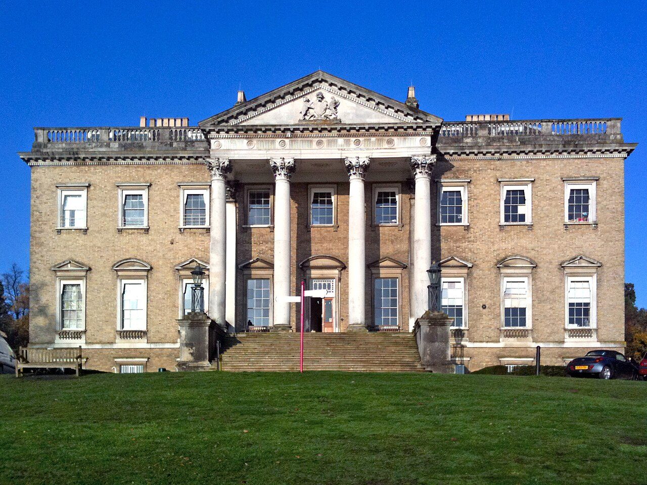 Claremont House · Photo: Heathermitch · CC BY-SA 3.0
A−History Grade
History of Esher · Historic England
70 listed buildings, 3 of them Grade I
Historic England counts them inside Esher’s built-up area, 74 for every 10,000 residents. It also has 2 scheduled monuments. We have photos of 8 of its listed buildings. 21% of its homes were built before 1919. Esher grades A− for history: #8 of 65 in Surrey.
Listed buildings
70
74 per 10,000 residents
Grade I
3
exceptional interest
Grade II*
5
more than special interest
Scheduled monuments
2
1 registered park or garden
Homes built before 1919
21%
typical UK town 15%
In pictures
Esher in 10 photos
Nearly every Grade I and II* building, photographed. Tap a photo to step through them full screen.
 Church of St GeorgeGrade I listed
 ClaremontGrade I park or garden
 The Bear HotelGrade II listed
 Friends' Meeting HouseGrade II listed
 Former Embassy CinemaGrade II listed+5See all photos
Photos from Wikimedia Commons and Geograph, copied to our own server, each credited to its photographer with its licence; names open the building’s page or its official list entry.
The map
Where Esher’s history is
Every Grade I and II* building, monument and historic park, over the age of each neighbourhood’s homes.
Grade IGrade II*Scheduled monumentPark or garden
Homes built before 1919, by neighbourhoodunder 10%10–25%25–50%50%+
0 of 6neighbourhoods have mostly pre-1919 homes; in the oldest, 40% were built before 1919.
Hover a dot for its name; tap one with a photo to open it.
70 listed buildings by grade
3 Grade I5 Grade II*62 Grade II
Historic England lists buildings in three grades: Grade I for buildings of exceptional interest (about 2.5% of all listed buildings), Grade II* for particularly important buildings of more than special interest (about 5.8%), and Grade II for buildings of special interest (about 91.7%). Listing protects the whole building, inside and out.
Every entry on the National Heritage List for England whose point lies inside the ONS 2022 built-up-area boundary. One list entry can cover a terrace or a group of buildings. Neighbourhood dots: the population-weighted centre of each Census 2021 output area, coloured by its neighbourhood’s (LSOA’s) share of homes built before 1919 (Valuation Office Agency, March 2025).
Grade I
The 3 Grade I listed buildings in Esher
Buildings of exceptional interest, about 2.5% of all listed buildings. 2 are photographed. Each opens its own page, with the official list entry.
 I
Church · listed 1953St George's ChurchOn the list as Church of St GeorgePhoto: Motmit at en · CC BY-SA 3.0
House · listed 1953Wayneflete TowerOn the list as Wayneflete's Tower
Grade II*
The 5 Grade II* listed buildings in Esher
Particularly important buildings of more than special interest. 3 are photographed.
 II*
Street furniture · listed 1969MilestonePhoto: C Woodward · CC BY-SA 2.0
 II*
House · listed 1953The Belvedere, 250 Yards South West of Claremont HousePhoto: Andy Potter · CC BY-SA 2.0
 II*
House · listed 1969White CottagePhoto: Ian Capper · CC BY-SA 2.0
House · listed 1984Former walled kitchen garden to Claremont House
Memorials · listed 1953Obelisk 10 Yards to Rear of Number 6 (Home Farm House)
What’s protected
Most of Esher’s listed buildings are homes
Every listed building sorted by what its list name says it is.
Houses, terraces & villas48
Churches, chapels & priories8
Inns, shops & warehouses5
Memorials, crosses & tombs4
Walls, gates & bridges3
Street furniture2
48 entries (69%) are houses, terraces and villas. 8 are churches, chapels and priories, including 1 of the 3 Grade I buildings.
Buildings are sorted by words in each entry’s name (church, gate, inn, memorial…): the list’s open data has no building type. An entry named only by its address counts as a house.
Grade II
62 Grade II listed buildings
Most listed buildings are in this grade, which covers buildings of special interest. Open any building to read its official list entry.
All 62 Grade II listed buildings, A to Z
Alma Arms Public HouseAnchell Tomb, 5 Yards East of North West Corner of Chancel of Church of St GeorgeBrett Tomb 8 Yards South of South Aisle of Christ ChurchChrist ChurchChurch of All SaintsClaremont BarnClaremont Ice HouseClarke Tomb 8 Yards South of South East Corner of Christ ChurchClive HouseClover WayCoal Tax Post Outside Cricketfield CottageCoal Tax Post Outside Lessworth at Ngr Tq 14806474Coal Tax Post at Ngr Tq 14616408Coal Tax Post on North Side of Railway Embankment at Ngr Tq 14026580CobblestonesDrinking Fountain and Surrounding Railings Opposite Number 72East and West Lodges to Esher PlaceEncott Force Cottage the Cottage WesteriaEntrance Piers and Railings to the Old Red HouseEsher Memorial CrossEsher Place and balustrade to the east entranceFormer Embassy CinemaFormer NatWest BankFriends' Meeting HouseGarden Reach CottageGarden Temple in Grounds to Rear of Number 36Garden Walls with Gateway to Esher Place Gardens, At Number 7 (Garden Reach Cottage)Garson Farm HouseGate Piers to Claremont ParkGrapes Cottage Grapes HouseHawkshill Cottage and the LodgeHawkshill PlaceHome Farm HouseLodge to Moore PlaceMyrtle CottagesNorth and South Lodges and Gates to Claremont HouseOrangery to Esher Place 15 Yards to east of No 7 (Garden Reach Cottage)Parker Tomb, 8 Yards East of North West Chancel Corner of Church of St GeorgePelham Vase in Grounds of No 30 (Esher Place)Post by the Toll House at Ngr Tq 1450 6532Pump, Opposite the Bear HotelSandown HouseSentosaStatue of Britannia Opposite Number 77, High StreetTawny HouseThe Bear HotelThe ChequersThe CloseThe Gardener's HouseThe LammasThe Old CottageThe Old Red HouseTravellers RestWhite Lady Milestone Opposite the Orleans Public House136 and 138, High Street68 and 69, West End Lane76 and 78, Milbourne Lane77, High Street80, Milbourne Lane83, High Street85, High Street99-103, High Street
Conservation areas
3 conservation areas cover 6.1% of Esher
Areas the council protects as a whole: demolition and changes to how buildings look need consent, and trees are protected.
Esher 197317 ha
West End 197714 ha
Weston Green 19772 ha
33 hain conservation areas, of 544 ha inside the built-up area.
The first, Esher, was designated in 1973; the newest, Weston Green, in 1977. 31 of the 70 listed buildings stand in one.
Historic England’s conservation areas layer, supplied by councils (incomplete in places, so a page fact, never graded). Hectares are the part of each area inside the built-up area.
How the list grew
28 of Esher’s 70 listed buildings were added in 1984
The year each building now on the list was first listed.
1984 · 281969 · 131953 · 7
19501960197019801990200020102020
The first 7 entries were listed in 1953, 3 of the 3 Grade I buildings among them. 28 came in 1984, in the national resurvey of the 1970s and 80s. Only 3 have been added in the last 15 years.
Monuments & landscapes
Monuments, parks and gardens
Designations that overlap the town by a tenth of their area or half a hectare.
2 scheduled monuments
Nationally important archaeological sites and monuments, protected by law; work on them needs consent from the Secretary of State, advised by Historic England.

1 registered park or garden
ClaremontGrade I
History Grade
Esher grades A− for history
Protected heritage and the age of the town’s homes, against all UK towns.
Protected heritage, for its size and in all (88 points, 93 per 10,000 residents)More than 76% of UK towns
Homes built before 1919 (21%)More than 64% of UK towns
Two measures, each ranked against every UK town of 1,000 or more, with protected heritage counting twice as much as the age of homes. Protected heritage counts each listed building by its grade (Grade I three points, II* two, II one), each scheduled monument and battlefield two, and each registered park or garden by its grade; it is ranked both per 10,000 residents and as a total, so a village with one fine church doesn’t outrank a historic city. The second measure is the share of homes built before 1919, from the Valuation Office Agency’s council tax records. History is a character grade: it describes the town and isn’t part of the overall grade.
Towns its size
Esher has the 34th most Grade I buildings of 698 towns its size
Places of 6,000–15,000 people outside London, by Grade I listed buildings.
Esher3
#162 of 698for listed buildings per resident (74 per 10,000). Brecon, Malmesbury and Ludlow lead.
33 have more. The typical town its size has 0.
Neighbours
Listed buildings in the places around Esher
| Town | People | Listed | Grade I | History |
|---|---|---|---|---|
| Esher | 9,484 | 70 | 3 | A− |
| West Molesey | 47,144 | 85 | 1 | B |
| Hersham | 12,622 | 9 | 0 | C− |
| Walton-on-Thames | 27,016 | 32 | 2 | C |
| Cobham | 17,505 | 45 | 1 | B− |
| Kingston upon Thames | 166,333 | 161 | 3 | B |
| Weybridge | 15,918 | 42 | 0 | B |
| Upper Halliford | 2,337 | 2 | 0 | D |
In brief
Esher in brief
Measured per resident, Esher has more listed heritage than 76% of UK towns. In all there are 70 listed buildings, 3 of them Grade I, including Claremont. Only 33 of the 698 towns nearest its size have more Grade I buildings.
Its older streets lie in 3 conservation areas, the first designated in 1973. Of the whole list, 69% are houses, terraces and villas. Beyond that, Charles Edward, Duke of Saxe-Coburg and Gotha (1884) was born here before 1900; it also has 2 scheduled monuments; and 21% of its homes were built before 1919, close to the 15% in the typical UK town.
Questions about Esher’s history
How many listed buildings are there in Esher?
Historic England lists 70 buildings inside Esher’s built-up area: 3 Grade I, 5 Grade II* and 62 Grade II.
What are the Grade I listed buildings in Esher?
3, including Church of St George, Claremont House and Wayneflete's Tower.
Are there scheduled monuments in Esher?
Yes, 2 scheduled monuments, including The Belvedere, Claremont and The White Lady Milestone, junction of Portsmouth Road and Esher Station Road.
How many conservation areas are there in Esher?
3, covering about 33 hectares of the town. The largest are Esher and West End.
When were Esher’s buildings listed?
The first in 1953; the most, 28, in 1984.
How old are the homes in Esher?
21% of homes were built before 1919 and 48% before 1940, from the Valuation Office Agency’s council tax records (March 2025).
© Historic England 2026. Contains Ordnance Survey data © Crown copyright and database right 2026. The National Heritage List for England is the official, up-to-date register of all nationally protected historic buildings and sites in England; check an entry on Historic England’s website before relying on it.
Sources: Historic England, National Heritage List for England (listed buildings, scheduled monuments, registered parks and gardens, battlefields, World Heritage Sites), October 2026, inside the ONS 2022 built-up-area boundary · Valuation Office Agency, Council Tax: stock of properties by build period (31 March 2025) · TownRatings grades: our own summary of the data, ranked against UK towns only · Historic England conservation areas (supplied by local planning authorities; October 2026). All under the Open Government Licence v3.0.
Contains public sector information licensed under the Open Government Licence v3.0. Contains HM Land Registry data © Crown copyright and database right 2026. Contains OS data © Crown copyright and database right 2026 (ONS boundaries). Northern Ireland: Source: NISRA; contains Land & Property Services data and Ordnance Survey of Northern Ireland information, © Crown copyright, licensed under the Open Government Licence v3.0. Scotland: contains National Records of Scotland data, Registers of Scotland data and SEPA data, © Crown copyright / © SEPA 2025, licensed under the Open Government Licence v3.0.