 A
House · listed 1987West Pier, Public ConveniencePhoto: Kristijrn · CC BY-SA 4.0
 West Pier, Public Convenience · Photo: Kristijrn · CC BY-SA 4.0
–Not graded
History of Rothesay · Historic Environment Scotland
151 listed buildings, 7 of them in the top category
On the Historic Environment Scotland list, all of them stand inside Rothesay’s locality, 359 for every 10,000 residents. It also has 3 scheduled monuments. We have photos of 18 of its listed buildings and 5 old views of the town.
Listed buildings
151
359 per 10,000 residents
Category A
7
national importance
Category B
61
regional importance
Scheduled monuments
3
nationally important sites
In pictures
Rothesay in 25 photos and old views
Tap a photo to step through them full screen.
 Victoria Street, The Winter GardensCategory A listed
 Rothesay Castle, castle 75m N of Bute MuseumScheduled monument
 Academy Road, Rothesay Academy Including Retaining Wall, Boundary Wall and GatepiersCategory B listed
 Market Cross, High StreetCategory C listed
 1-6 Albert Place and West Princes Street, Former Royal HotelCategory B listed+20See all photos
Photos from Wikimedia Commons and Geograph, copied to our own server, each credited to its photographer with its licence; names open the building’s page or its official list entry.
Through time
Rothesay from 1890 to 1903
5 old photos and postcards, in date order. All public domain, made before 1950.
 c. 1890
 c. 1890
 c. 1890
 1893
 1903
Public domain, from Wikimedia Commons, copied to our own server. Each credit opens the image’s page with its full description and history.
The map
Where Rothesay’s history is
Every Category A and B building, monument and historic park.
Category ACategory BScheduled monument400 m from Columshill Street, St Andrew's Roman Catholic Church , Including Priest's House, Boundary Wall and Piers
4 of 7Category A buildings stand within 400 m of Columshill Street, St Andrew's Roman Catholic Church , Including Priest's House, Boundary Wall and Piers, a five-minute walk. So do 63 of the 151 listed buildings.
Hover a dot for its name; tap one with a photo to open it.
151 listed buildings by grade
7 Category A61 Category B83 Category C
Historic Environment Scotland lists buildings in three categories: Category A for buildings of national or international importance (about 7.5% of listed buildings), Category B for buildings of regional importance (about 50%), and Category C for buildings of local importance (about 43%). Listing protects the whole building, inside and out.
Every entry on Historic Environment Scotland’s designations whose point lies inside the NRS 2022 locality boundary. One list entry can cover a terrace or a group of buildings.
Category A
The 7 Category A listed buildings in Rothesay
Buildings of national or international importance, about 7.5% of all listed buildings; 4 of these stand within 400 m of Columshill Street, St Andrew's Roman Catholic Church , Including Priest's House, Boundary Wall and Piers. 5 are photographed. Each opens its own page, with the official list entry.
 A
House · listed 1978Victoria Street, The Winter GardensPhoto: Teddy Birmingham · CC BY-SA 3.0
 A
Walls & gates · listed 1988Argyle Street, Rothesay Pavilion Including House at Rear and Boundary WallPhoto: Thomas Nugent · CC BY-SA 2.0
 A
Memorials · listed 1971High Kirk of Rothesay, Bute MausoleumPhoto: Raibeart MacAoidh · CC BY-SA 2.0
 A
House · listed 197155, 57 and 59 High Street Bute Estate Office Including OutbuildingPhoto: Leslie Barrie · CC BY-SA 2.0
Walls & gates · listed 1971Ardencraig Road, Tor House, Including Boundary Wall, Gatepiers and Gates
Walls & gates · listed 1971Columshill Street, St Andrew's Roman Catholic Church , Including Priest's House, Boundary Wall and Piers
Category B
The 61 Category B listed buildings in Rothesay
Buildings of regional importance. 12 are photographed.
 B
Walls & gates · listed 1997Academy Road, Rothesay Academy Including Retaining Wall, Boundary Wall and GatepiersPhoto: Jonathan Nélis · CC BY-SA 3.0
 B
House · listed 19971-6 Albert Place and West Princes Street, Former Royal HotelPhoto: Andrew Abbott · CC BY-SA 2.0
 B
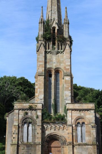
Church · listed 1997Argyle Street, West ChurchPhoto: Leslie Barrie · CC BY-SA 2.0
 B
Walls & gates · listed 1996Castle Street, Trinity Church, Including Hall, Boundary Wall, Gatepiers, Lamps and RailingsPhoto: Jim Barton · CC BY-SA 2.0
 B
Inns & shops · listed 1997Glenburn Hotel, Glenfaulds CottagePhoto: Chris Morgan · CC BY-SA 2.0
 B
Walls & gates · listed 1997Glenburn Road, Glenburn Hotel Including Terrace Wall, Boundary Walls, Gatepiers and CottagesPhoto: Jonathan Nélis · CC BY-SA 3.0
 B
Public · listed 1997Stuart Street, Bute MuseumPhoto: DougRM · CC BY-SA 4.0
 B
Walls & gates · listed 1997Victoria Street, St Paul's Episcopal Church Including Boundary WallPhoto: Iain McKenzie · CC BY-SA 2.0
 B
House · listed 199710 and 12 Bishop Street, Post OfficePhoto: Thomas Nugent · CC BY-SA 2.0
 B
House · listed 197131 High Street (Flats 1-25, Inclusive Nos) (Former Castle Street, County Hall, Including Former Prison Cells)Photo: Leslie Barrie · CC BY-SA 2.0
 B
House · listed 199739 and 41 Victoria StreetPhoto: Fitzsimons · CC BY-SA 4.0
 B
House · listed 199743-55 (Odd Nos) Victoria Street, Rothesay Victoria Hotel, Including Lampstands and PlaquePhoto: Fitzsimons · CC BY-SA 4.0
Show the other 49
House · listed 1971Ardencraig Road, Ardencraig House, Including Gatepiers
Walls & gates · listed 1987Ardencraig Road, Rockhill Castle, Including Boundary Walls, Terrace Walls and Verandah
Walls & gates · listed 1998Ascog, Millbank House Including Boundary Wall, Gatepiers, Gates and Terrace Fence
Walls & gates · listed 1998Ascog, Millburn House Including Boundary Wall
Walls & gates · listed 1971Barone Road, Bute Fabrics Including Boundary Walls and Gatepiers
Walls & gates · listed 1980Battery Place and Glenburn Road, Beattie Court (Former Aquarium) Including Stairs, Boundary Wall and Piers
Walls & gates · listed 1997Bishop Terrace, Beechwood Hotel Including Boundary Wall and Gatepiers
Walls & gates · listed 1996Chapelhill Road, Free Church of Scotland, Including Boundary Walls
House · listed 1997Glenburn Road, East Firwood and West Firwood
Walls & gates · listed 1971High Kirk of Rothesay Including Outbuilding, Graveyard, Boundary Wall and Gatepiers
Walls & gates · listed 1997Minister's Brae, Marionslea Including Boundary Wall and Gatepiers
House · listed 1997Mount Stuart Road, Sewage Screening Chamber and Public Convenience
Walls & gates · listed 1997Westland Road, Ivybank, Including Boundary Walls and Gatepiers
House · listed 198014-26 (Even Nos) Russell Street and 19, 21, 23 Mill Street
House · listed 199719-25 (Inclusive Nos) East Princes Street, Duncan's Halls
House · listed 199719-27 Mount Stuart Road, Wimbleton, Including Boundary Walls and Gatepiers
House · listed 19712 Union Street (Colbeck Place) Including Boundary Wall
House · listed 199720 Battery Place, Glendale
House · listed 199723 Craigmore Road, Craigend House, Including Boundary Wall and Gatepiers
House · listed 199726 Argyle Place, Including Boundary Wall and Gatepiers
House · listed 199727 and 28 Craigmore Road, Orcadia, Including Boundary Wall and Gatepiers
House · listed 19713 Stuart Street
House · listed 19803-9 (Odd Nos) Columshill Place
House · listed 198032 Columshill Street and 2 Columshill Place
House · listed 199733 and 35 Argyle Terrace Including Outbuilding and Boundary Wall
House · listed 199735 Craigmore Road, Montford House, Including Boundary Walls and Gatepiers
House · listed 199138 Bridge Street, Mavisbank, Including Boundary Walls
House · listed 19974 King Street
House · listed 199748 and 49 Crichton Road, Craigmore Hotel, Including Boundary Wall
House · listed 197151 and 53 High Street
House · listed 199760 and 62 Montague Street and 3, 5 and 7 Tower Street
House · listed 197161 and 67 High Street Including Rear Outbuilding (No 65)
House · listed 19977 and 9 Castle Street, Bute Housing Association
Historic streets
Including Boundary Walls and Gatepiers has the most listed buildings
Streets by the listed entries with an address on them. One entry can be a whole terrace, so long rows count once.
Including Boundary Walls and Gatepiers22 listed · 15 II*
Including Boundary Wall and Gatepiers6 listed · 5 II*
Including Boundary Wall5 listed · 1 II*
Victoria Street5 listed · 1 II*

Columshill Street4 listed
Crichton Road Including Boundary Wall and Gatepiers4 listed
Montague Street4 listed
Battery Place Including Boundary Wall3 listed
Boundary Wall and Gatepiers3 listed
Columshill Place3 listed
Crichton Road Including Boundary Wall3 listed
Of the 151 entries, 99 are named by a street address; the rest are named buildings such as churches, halls and bridges.
What’s protected
Most of Rothesay’s listed buildings are homes
Every listed building sorted by what its list name says it is.
Houses, terraces & villas115
Walls, gates & bridges28
Public & civic buildings4
Memorials, crosses & tombs2
Churches, chapels & priories1
Inns, shops & warehouses1
115 entries (76%) are houses, terraces and villas. 1 are churches, chapels and priories.
Buildings are sorted by words in each entry’s name (church, gate, inn, memorial…): the list’s open data has no building type. An entry named only by its address counts as a house.
Category C
83 Category C listed buildings
This category covers buildings of local importance. Open any building to read its official list entry.
All 83 Category C listed buildings, A to Z
Academy Road, 1-6 (Inclusive Nos) Academy TerraceArdencraig Road, Ardencraig LodgeArgyle Street, 1-8 (Inclusive Nos) Grand Marine Court, Including Porch, Boundary Wall, Gatepiers and RailingsAscog, 1 and 2 Millburn Cottages Including Front Wall and GatepiersAscog, Agnes Patrick Guest House Including Boundary Wall and GatepiersAscog, Millbank Stables, Coach-House and Dower House Including Boundary Wall, Gatepiers and CourtyardBarone Road, Barone CottageEastlands Road, Edgehill and Hillpark, Including Outbuilding, Boundary Wall and GatepiersHigh Street, Former United Free Church, Including Boundary WallInner Harbour, Former Weighing House Including Weigh BridgeMarket Cross, High StreetMid Pier, Shelter (Cabbie's Rest) and West Pier, Former Cabbie's Office/StoreMinister's Brae, Ashlea, Rowanlea, Beechlea, Elmlea and Oaklea Including Boundary WallsMinister's Brae, Hewison House Including Outbuildings, Boundary Walls and GatepiersVictoria Street, Esplanade Gardens, War MemorialWell Park Road, Rock Villa Including Boundary Wall and GatepiersWestland Road, Chapelhill Villa, Including Outbuilding, Boundary Wall, Gatepiers and Gate1 Argyle Place Including Boundary Wall1 and 1 1/2 York Terrace1, 1A, 2 and 2A Crichton Road Including Boundary Wall and Gatepiers1, 3 and 5 Montague Street1-3 (Inclusive Nos) East Princes Street, Albert Mansions1-5 (Inclusive Nos) John Street1-5 (Odd Nos) Watergate and 13 Albert Place Guildford Court Hotel10 and 11 Crichton Road Including Boundary Wall10-12 (Inclusive Nos) Albert Place11 Argyle Place Including Boundary Wall and Gatepiers11 and 11A Battery Place, Including Boundary Wall13 and 15 Bishop Street14 Argyle Place Including Boundary Wall and Gatepiers14 and 14A Battery Place Including Boundary Wall14 and 15 Crichton Road Including Boundary Wall15 Craigmore Road, Glencraig, Including Outbuildings, Boundary Walls and Gatepiers15 and 16 Battery Place, Marlborough, Including Boundary Wall16 Craigmore Road, Madras House, Including Boundary Walls and Gatepiers16 and 18 Columshill Street17, 19 and 21 Russell Street Including Boundary Wall to Union Street (Colbeck Place)19, 20 and 21 Crichton Road Including Boundary Wall and Gatepiers19-27 (Odd Nos) Bishop Street2 Argyle Place Including Boundary Wall2,4,6 and 8 West Princes Street20, 22 and 24 Columshill Street21 and 22 Battery Place Including Boundary Wall21, 23 and 25 Montague Street22 Craigmore Road, Craigmore House, Including Sundial, Boundary Wall and Gatepiers23 and 24 Crichton Road, Brighton Terrace, Including Boundary Walls and Gatepiers24 Craigmore Road, Craigend Retirement Home Including Outbuildings, Boundary Wall and Gatepiers25 and 26 Crichton Road, Brighton Terrace, Including Boundary Walls and Gatepiers26 Castle Street26 and 28 Columshill Street27 and 28 Crichton Road, Brighton Terrace, Including Boundary Walls and Gatepiers28 Battery Place, Alamein House Including Boundary Wall29 and 30 Crichton Road, Brighton Terrace, Including Boundary Walls and Gatepiers3, 3A, 4 and 4A Crichton Road Including Boundary Wall and Gatepiers30 Columshill Street30-34 (Even Nos) Mount Pleasant Road Including Boundary Wall and Gatepiers31 Argyle Terrace Including Boundary Wall and Gatepiers31 and 32 Crichton Road, Brighton Terrace, Including Boundary Walls and Gatepiers33 and 34 Crichton Road, Brighton Terrace, Including Boundary Walls and Gatepiers34 Castle Street, Including Boundary Wall and Gatepiers36 and 38 Castle Street37 Victoria Street4 Bishop Terrace Including Boundary Wall and Gatepiers4 Columshill Place41 Argyle Street Including Boundary Wall, Gatepiers and Railings43 and 44 East Princes Street, Including Boundary Wall45, 46 and 47 Crichton Road Including Boundary Wall and Gatepiers5 Bishop Terrace Including Boundary Wall and Gatepiers6 Columshill Place6,8,10 and 12 Bridgend Street (Former Bridgend Church Hall)63, 65 and 67 Victoria Street64, 66 and 68 Montague Street69 and 71 Victoria Street7 Craigmore Road Including Boundary Wall and Gatepiers7 Crichton Road Including Boundary Wall7,8 and 9 Argyle Street7-9 (Inclusive Nos) Albert Place and 5-9 (Odd Nos) West Princes Street70, 72 and 74 Montague Street73 Victoria Street8 Columshill Place8 and 9 Bishop Terrace Including Dovecot, Coach-House, Boundary Wall and Gatepiers9 and 10 Battery Place Including Boundary Wall90 High Street, Including Boundary Wall
Conservation areas
1 conservation area covers 41% of Rothesay
Areas the council protects as a whole: demolition and changes to how buildings look need consent, and trees are protected.
Rothesay115 ha
115 hain conservation areas, of 278 ha inside the locality.
137 of the 151 listed buildings stand in one.
Historic Environment Scotland’s conservation areas layer, supplied by councils (incomplete in places, so a page fact, never graded). Hectares are the part of each area inside the locality.
How the list grew
More than half of Rothesay’s listed buildings were added in one year, 1997
The year each building now on the list was first listed.
1997 · 1031980 · 211971 · 14
19501960197019801990200020102020
The first 14 entries were listed in 1971, 4 of the 7 Category A buildings among them. 103 came in 1997. Only 1 has been added in the last 15 years.
Monuments & landscapes
Monuments, parks and gardens
Designations that overlap the town by a tenth of their area or half a hectare.
3 scheduled monuments
Nationally important archaeological sites and monuments, protected by law; work on them needs consent from Historic Environment Scotland.
Rothesay Castle, castle 75m N of Bute MuseumEcclesiastical: chapel; Secular: castle

St Mary's Chapel,RothesayEcclesiastical: chapel
Thom's Water Cuts, aqueduct and dam, Little Barone to Kirk DamIndustrial: inland water
Born here
12 notable people born in Rothesay before 1900
Their lives on one timeline, earliest first.
Saint Blane
Matthew Stewart
William Leitch
John Tiffin Stewart
Thomas Gillies
Robert Gillies
Jimmy Haig
George Leslie Hunter
Alister Howden
George Spence
John Anderson
Sheina Marshall
6007509001050120013501500165018001950

George Leslie Hunter1877–1931 · Painter (1877-1931)

Matthew Stewart1717–1785 · Scottish mathematician (1717-1785)

Sheina Marshall1896–1977 · Scottish marine biologist (1896-1977)
SB
Saint Blane550–590 · Scottish bishop and confessor
WL
William Leitch1814–1864 · Scottish scientist and Presbyterian minister

Thomas Gillies1828–1889 · New Zealand politician (1828-1889)
AH
Alister Howden1877–1938 · New Zealand cricketer (1877-1938)
GS
George Spence1877– · Scottish footballer (1877-?)
Everyone born in Rothesay → Birthplaces from Wikidata; portraits from Wikimedia Commons.
Towns its size
Rothesay has the 5th most Category A buildings of 211 towns its size
Scottish towns of 2,000–11,000 people, by Category A listed buildings.
Rothesay7
#7 of 211for listed buildings per resident (359 per 10,000). Kirkcudbright, Banff and Anstruther lead.
Only Lanark, Banff, Kelso and Jedburgh have more. The typical town its size has 0.
Neighbours
Listed buildings in the places around Rothesay
In brief
Rothesay in brief
Rothesay has 151 listed buildings, 7 of them in the top category, including West Pier, Public Convenience. Its Category A buildings cluster together: 4 of them stand within 400 m of Columshill Street, St Andrew's Roman Catholic Church , Including Priest's House, Boundary Wall and Piers. Only 4 of the 211 towns nearest its size have more Category A buildings. A conservation area protects part of it.
Most entries on the list, 76%, are houses, terraces and villas. Of the 12 people born here before 1900, the best known include George Leslie Hunter (1877), Matthew Stewart (1717) and Sheina Marshall (1896). The big year was 1997, when 103 of the 151 went on the list. Otherwise the figures are ordinary: it also has 3 scheduled monuments.
Questions about Rothesay’s history
How many listed buildings are there in Rothesay?
Historic Environment Scotland lists 151 buildings inside Rothesay’s locality: 7 Category A, 61 Category B and 83 Category C.
What are the Category A listed buildings in Rothesay?
7, including Ardencraig Road, Tor House, Including Boundary Wall, Gatepiers and Gates, Argyle Street, Rothesay Pavilion Including House at Rear and Boundary Wall, Columshill Street, St Andrew's Roman Catholic Church , Including Priest's House, Boundary Wall and Piers, High Kirk of Rothesay, Bute Mausoleum, Victoria Street, The Winter Gardens and West Pier, Public Convenience.
Which street in Rothesay has the most listed buildings?
Including Boundary Walls and Gatepiers (22), Including Boundary Wall and Gatepiers (6) and Including Boundary Wall (5) have the most listed entries named by an address. One entry can be a whole terrace.
Are there scheduled monuments in Rothesay?
Yes, 3 scheduled monuments, including Rothesay Castle, castle 75m N of Bute Museum, St Mary's Chapel,Rothesay and Thom's Water Cuts, aqueduct and dam, Little Barone to Kirk Dam.
How many conservation areas are there in Rothesay?
1, covering about 115 hectares of the town. The largest is Rothesay.
When were Rothesay’s buildings listed?
The first in 1971; the most, 103, in 1997.
Are there old photos of Rothesay?
Yes: 5 public-domain photos and postcards from 1890 to 1903, all on this page.
Who was born in Rothesay?
Among people born before 1900: George Leslie Hunter (1877), Matthew Stewart (1717), Sheina Marshall (1896), Saint Blane (550) and William Leitch (1814).
Rothesay has no History Grade.
Listed buildings, scheduled monuments, gardens and designed landscapes, battlefields, conservation areas and World Heritage Sites: Historic Environment Scotland, Open Government Licence v3.0. Check an entry on Historic Environment Scotland’s portal before relying on it.
Sources: Historic Environment Scotland designations (listed buildings, scheduled monuments, gardens and designed landscapes, battlefields, World Heritage Sites), October 2026, inside the NRS 2022 locality boundary · Historic Environment Scotland conservation areas (compiled from councils; October 2026). All under the Open Government Licence v3.0.
Contains public sector information licensed under the Open Government Licence v3.0. Contains HM Land Registry data © Crown copyright and database right 2026. Contains OS data © Crown copyright and database right 2026 (ONS boundaries). Northern Ireland: Source: NISRA; contains Land & Property Services data and Ordnance Survey of Northern Ireland information, © Crown copyright, licensed under the Open Government Licence v3.0. Scotland: contains National Records of Scotland data, Registers of Scotland data and SEPA data, © Crown copyright / © SEPA 2025, licensed under the Open Government Licence v3.0.