Murfreesboro dates to 1811, and 27 of its places are on the National Register
More historic than 66% of U.S. towns · #53 of 177 in Tennessee. What drives it
Most of Murfreesboro was built recently: 2% of its homes predate 1940 and the median home dates from 2002. 27 places in town are on the National Register, among them six historic districts with 246 buildings between them. Below: 9 old photos and papers, maps from 1887 on, and the census since 1830.
Founding year: Wikidata. First post office: 1813.The full story ↓
History grade
What drives Murfreesboro’s History grade
On its age, its old homes and the National Register, Murfreesboro is more historic than 66% of U.S. towns, #53 of 177 in Tennessee. Its National Register listings hold the grade up; its share of homes from before 1940 pulls it down.
B+
HistoryA character grade: shown, never part of Murfreesboro’s overall grade.
Among the 400 U.S. cities of 100,000 or more, Murfreesboro ranks #188 on History.
Tennessee towns list more on the Register than most of the country (a typical Tennessee town has 6.1 per 10,000 residents, the U.S. 2.4), so Murfreesboro’s 17.8 sits above most of its state (70% of Tennessee towns have fewer) while its 287 historic buildings outnumber those of 95% of U.S. towns.
Newer cities are common at Murfreesboro’s size: in the typical U.S. city of 100,000 or more, 5% of homes predate 1940.
How sure. Graded on any two of the three inputs instead, the letter would range from C+ to A. The pre-1940 share (±0.5 points) is firm at this size. Two sources give 1811.
Founding year: Wikidata (other dates in Quick answers). Homes: Census ACS 2020–24. National Register: National Park Service, May 2026 list; each listing counted once (boundary changes and added documentation belong to their listing), and a historic district counts its contributing buildings. How TownRatings grades history →
What stands out about Murfreesboro’s past
Read from the archive, the National Register and the record. The page puts what stands out first.
On October 27, 1811, the Tennessee General Assembly designated the location for a new county seat for Rutherford County, giving it the name Cannonsburgh in honor of Newton Cannon, representative to the assembly for the local area. At the suggestion of William Lytle, it was renamed Murfreesborough on November 29, 1811, after Revolutionary War hero Colonel Hardy Murfree, great-grandfather of author Mary Noailles Murfree. The name was shortened to Murfreesboro in January 1812, when the town was formally chartered.
Passages that mention Murfreesboro, cut from the printed page as they were published.
Historical sketches of the Ninth Michigan infantry (General Thomas' headquarters guards) with an account of the battle of Murfreesboro, Tennessee, Sunday, July 13, 18621913Read the page →
Read the text
across eight miles to the Murfreesboro pike which we struck two miles south of Lavergne, and went south to within ten miles of Murfreesboro. Col. Parkhurst's diary agrees exactly with mine in these dates, routes and distances, and Capt. B. H. Stevens and Comrade Frank Lester say their
Text read by machine from the scan; it may contain errors.
Historical sketches of the Ninth Michigan infantry (General Thomas' headquarters guards) with an account of the battle of Murfreesboro, Tennessee, Sunday, July 13, 18621913 · page 22Read the page →
Read the text
The court exhonorated General at Murfreesboro. The Federal senti- Crittenden and Colonel Duffield, and nels were not aware of their mistake laid all the blame for the capture of until they were surrounded by the Murfreesboro on Colonel Lester who Rangers, who, with pistols drawn, was dishonorably dismissed. captured the entire picket force with- THE FLAG OF TRUCE. Comrade out firing a gun to arouse the sleep- B. G. Lyman writes me that the mesing garrison." {But I surely heard senger from Forrest bearing the two guns).
Text read by machine from the scan; it may contain errors.
Scans and text from the Internet Archive. Books published in 1930 or earlier, which are in the public domain.
Timeline
Murfreesboro, 1790 to 1962
Woven from the archive, old maps, post office records, the National Register and the people born here.
Every edition of the U.S. Geological Survey’s map of Murfreesboro. Tap a year, or press play to watch the town change.
1916Murfreesboro sheet · 1:62,500
U.S. Geological Survey historical topographic maps (public domain), via Esri’s collection of the scans. The red ring marks the center of Murfreesboro.
Every building
Murfreesboro, building by building, 1887–1924
Fire insurance maps drew every building, what it was made of and what it was used for, so insurers could price the risk of fire. Pick a year, then a sheet.
In 1811, according to Wikidata. Murfreesboro’s post office opened in 1813, and the census of 1830 counted 786 people here.
How does Murfreesboro rank for history?
Murfreesboro is more historic than 66% of U.S. towns, #53 of 177 in Tennessee. The History grade combines the town’s founding era, the share of homes built before 1940 and its National Register listings. It’s a character grade, so it isn’t part of the overall grade. How it works.
What is on the National Register in Murfreesboro?
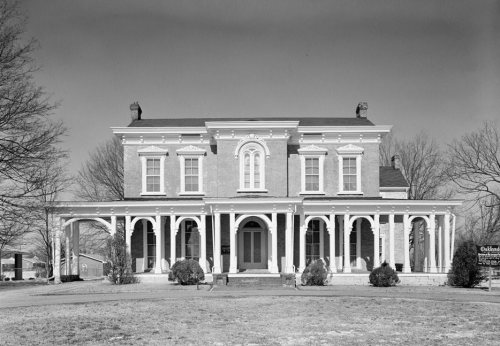
27 listings: 19 buildings, among them the Oaklands (listed 1970, the first), 6 historic districts with 246 contributing buildings, and 3 sites. 287 historic buildings in all.
How old are the homes in Murfreesboro?
2% of Murfreesboro’s homes were built before 1940 (Census estimate), against a typical 4.9% for a Tennessee town; the median home was built in 2002.
Founding dates: Wikidata, Wikipedia, the U.S. post office records of Blevins & Helbock (CC0) and the Census. Homes by year built: Census ACS 2020–24. National Register of Historic Places: National Park Service (list of May 22, 2026). Old photos, postcards and papers: Wikimedia Commons, the Library of Congress and other public archives, credited on each item’s page. Maps: U.S. Geological Survey historical topographic maps (via Esri) and Sanborn fire-insurance maps (Library of Congress). History text and census tables: Wikipedia (CC BY-SA 4.0). Places that used to be: USGS Geographic Names Information System (2021).
From Wikimedia Commons (5), the Library of Congress (4), Wikidata (3), the National Register of Historic Places (28), Wikipedia, Wikidata and Wikipedia for famous people, U.S. Geological Survey historical maps, U.S. Census counts (via Wikipedia), the US Post Offices dataset (Blevins & Helbock), the USGS Geographic Names Information System, Sanborn fire insurance maps (Library of Congress) and old county and town histories (Internet Archive). Archive images are copied here with their credits and licenses, shown on each photo’s page. Refreshed monthly.






 1860
 1860
 1860
 1860
 1860
 1860
 1860


