Johnson City dates to 1856, and 21 of its places are on the National Register
More historic than 64% of U.S. towns · #58 of 177 in Tennessee. What drives it
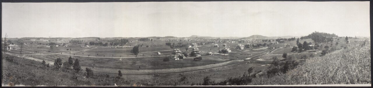
Most of Johnson City was built recently: 9% of its homes predate 1940 and the median home dates from 1983. 21 places in town are on the National Register, among them the Mountain Branch, National Home For Disabled Volunteer Soldiers, a National Historic Landmark, and six historic districts with 734 buildings between them. Below: 3 old photos and papers, maps from 1891 on, and the census since 1880.
Founding year: Wikidata; Wikipedia’s history section gives the same year. First post office: 1840.The full story ↓
History grade
What drives Johnson City’s History grade
On its age, its old homes and the National Register, Johnson City is more historic than 64% of U.S. towns, #58 of 177 in Tennessee. Its National Register listings hold the grade up; its age pulls it down.
B
HistoryA character grade: shown, never part of Johnson City’s overall grade.
Tennessee towns list more on the Register than most of the country (a typical Tennessee town has 6.1 per 10,000 residents, the U.S. 2.4), so Johnson City’s 105 sits above most of its state (90% of Tennessee towns have fewer) while its 756 historic buildings outnumber those of 98% of U.S. towns.
How sure. Graded on any two of the three inputs instead, the letter would range from C to A−. The pre-1940 share (±1.1 points) is firm at this size. Two sources give 1856.
Founding year: Wikidata (other dates in Quick answers). Homes: Census ACS 2020–24. National Register: National Park Service, May 2026 list; each listing counted once (boundary changes and added documentation belong to their listing), and a historic district counts its contributing buildings. How TownRatings grades history →
What stands out about Johnson City’s past
Read from the archive, the National Register and the record. The page puts what stands out first.
The country’s official list of buildings and places worth saving. One is a National Historic Landmark, the highest tier. Boundary changes and added documentation are counted with their listing.
National Park Service, National Register of Historic Places. Photos from Wikimedia Commons, credited on each place’s page.
Places that used to be
Lost post offices, old corners, places now gone and burying grounds
Johnson City’s post office has been open since 1870. Eight other post offices opened and closed inside today’s town.
Longmire
1840–1876
Boons Creek
1841–1900
Pine Grove
1848–1854
Knob Creek
1856–1859
Johnson's Depot
1857–1868
Haynesville
1859–1861
Okolona
1859–1900
Johnson City
1870–today
National Soldiers Home
1901–1920
Mountain Home
1935–today
18401930today
Hamlets and corners on the map
Arbor HeightsAsburyAustin VillageAvondale ForestBeechwood CourtBel Air OneBel Air TwoBelmont AcresBig Valley Mobile Home ParkBoone TrailBoones CreekBreezy HillsBrentwoodBrookmeadBuckstone HillsCamelotCamelot TwoCamp WildwoodCarmolCarnegieCarter CrossingCharbrayCherokee GardensCherokee Hills
Gone or out of use
Appalachian HospitalhospitalBarnes SchoolschoolBoone Creek MilllocaleBoones Creek Church of the BrethrenchurchBoring ChapelchurchCollege Heights ChurchchurchEdwards AirportairportMaison InstituteschoolMcNeil SchoolschoolMiller SidinglocaleOak Hill SchoolschoolPine Grove SchoolschoolPrinceton SchoolschoolSinking Creek SchoolschoolValley View SchoolschoolZion Churchchurch
75family graveyards and cemeteries inside Johnson City
AustinBarneBarnett - Tiner HillBartonBaylessBereaBoone CreekBoones CreekBoones Creek Christian ChurchBoringBowersBowmanBowmanBrownCarr - ReevesCarrCarrCarr-Crumley-KrouseCarruthersClarkCollege HeightsCrumleyGallowayGilesHarringtonHarrison ChapelHighlandHossHuntHuntHuntJobeJones-BaylessKeenKinnickKrouseLeachLeonardLittle - KingLittleLongmireMarvins ChapelMeadowsMelvin-CarathersMillerMillerMonte Vista Memorial ParkMountain HomeMountain Home NationalMountain Home NationalOak HillOnksPatton ChapelPeoplesPhillipsPricePriceRangeReasonerSaint JohnShipleySimerlySlagleSnell - ChrisenberrySnow ChapelTiptonTipton-HaynesUnionWashington County Memory GardensWeemsWest LawnWhiteYoung - Lyle - StricklandYoungYoung
See all 75
Austin Cemetery · Barne Cemetery · Barnett - Tiner Hill Cemetery · Barton Cemetery · Bayless Cemetery · Berea Cemetery · Boone Creek Cemetery · Boones Creek Cemetery · Boones Creek Christian Church Cemetery · Boring Cemetery · Bowers Cemetery · Bowman Cemetery · Bowman Cemetery · Brown Cemetery · Carr - Reeves Cemetery · Carr Cemetery · Carr Cemetery · Carr-Crumley-Krouse Cemetery · Carruthers Cemetery · Clark Cemetery · College Heights Cemetery · Crumley Cemetery · Galloway Cemetery · Giles Cemetery · Harrington Cemetery · Harrison Chapel Cemetery · Highland Cemetery · Hoss Cemetery · Hunt Cemetery · Hunt Cemetery · Hunt Cemetery · Jobe Cemetery · Jones-Bayless Cemetery · Keen Cemetery · Kinnick Cemetery · Krouse Cemetery · Leach Cemetery · Leonard Cemetery · Little - King Cemetery · Little Cemetery · Longmire Cemetery · Marvins Chapel Cemetery · Meadows Cemetery · Melvin-Carathers Cemetery · Miller Cemetery · Miller Cemetery · Monte Vista Memorial Park · Mountain Home Cemetery · Mountain Home National Cemetery · Mountain Home National Cemetery · Oak Hill Cemetery · Onks Cemetery · Patton Chapel Cemetery · Peoples Cemetery · Phillips Cemetery · Price Cemetery · Price Cemetery · Range Cemetery · Reasoner Cemetery · Saint John Cemetery · Shipley Cemetery · Simerly Cemetery · Slagle Cemetery · Snell - Chrisenberry Cemetery · Snow Chapel Cemetery · Tipton Cemetery · Tipton-Haynes Cemetery · Union Cemetery · Washington County Memory Gardens · Weems Cemetery · West Lawn Cemetery · White Cemetery · Young - Lyle - Strickland Cemetery · Young Cemetery · Young Cemetery
US Post Offices dataset (Blevins & Helbock, CC0). Places and cemeteries from the USGS Geographic Names Information System (2021).
William Bean, traditionally recognized as Tennessee's first white settler, built his cabin along Boone's Creek near Johnson City in 1769. In the 1780s, Colonel John Tipton established a farm (now the Tipton-Haynes State Historic Site) just outside what is now Johnson City. During the State of Franklin movement, Tipton was a leader of the loyalist faction, residents of the region who wanted to remain part of North Carolina rather than form a separate state. In February 1788, an armed engagement took place at Tipton's farm between Tipton and his men and the forces led by John Sevier, the leader of the Franklin faction.
Nothing in the archives for these yearsWeddings on Main Street, storms, parades, school pictures, the old store. If it’s in your family album, it belongs here.
Every edition of the U.S. Geological Survey’s map of Johnson City. Tap a year, or press play to watch the town change.
1935Johnson City sheet · 1:24,000
U.S. Geological Survey historical topographic maps (public domain), via Esri’s collection of the scans. The red ring marks the center of Johnson City.
Every building
Johnson City, building by building, 1891–1920
Fire insurance maps drew every building, what it was made of and what it was used for, so insurers could price the risk of fire. Pick a year, then a sheet.
In 1856, according to Wikidata and Wikipedia’s history of the town. Johnson City’s post office opened in 1840, and the census of 1880 counted 685 people here.
How does Johnson City rank for history?
Johnson City is more historic than 64% of U.S. towns, #58 of 177 in Tennessee. The History grade combines the town’s founding era, the share of homes built before 1940 and its National Register listings. It’s a character grade, so it isn’t part of the overall grade. How it works.
What is on the National Register in Johnson City?
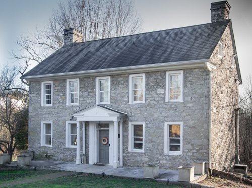
21 listings: 15 buildings, among them the Rocky Mount (listed 1970, the first), and 6 historic districts with 734 contributing buildings. 756 historic buildings in all.
How old are the homes in Johnson City?
9% of Johnson City’s homes were built before 1940 (Census estimate, ±1.1 points), against a typical 4.9% for a Tennessee town; the median home was built in 1983.
Founding dates: Wikidata, Wikipedia, the U.S. post office records of Blevins & Helbock (CC0) and the Census. Homes by year built: Census ACS 2020–24. National Register of Historic Places: National Park Service (list of May 22, 2026). Old photos, postcards and papers: Wikimedia Commons, the Library of Congress and other public archives, credited on each item’s page. Maps: U.S. Geological Survey historical topographic maps (via Esri) and Sanborn fire-insurance maps (Library of Congress). History text and census tables: Wikipedia (CC BY-SA 4.0). Places that used to be: USGS Geographic Names Information System (2021).
From Wikimedia Commons (3), Wikidata (2), the National Register of Historic Places (21), Wikipedia, U.S. Geological Survey historical maps, U.S. Census counts (via Wikipedia), the US Post Offices dataset (Blevins & Helbock), the USGS Geographic Names Information System and Sanborn fire insurance maps (Library of Congress). Archive images are copied here with their credits and licenses, shown on each photo’s page. Refreshed monthly.


 ★ Landmark





 1880


