Columbia has 148 places on the National Register, 5 of them National Historic Landmarks
More historic than 85% of U.S. towns · #15 of 169 in South Carolina. What drives it
Dated to 1787 (Wikidata), with 10% of its homes built before 1940 and 22 historic districts holding 2,583 contributing buildings. Most of Columbia was built recently: 10% of its homes predate 1940 and the median home dates from 1980. Below: 7 old photos and papers, maps from 1884 on, the census since 1830, and every listing on the Register.
Founding year: Wikidata. First post office: 1792.The full story ↓
History grade
What drives Columbia’s History grade
On its age, its old homes and the National Register, Columbia is more historic than 85% of U.S. towns, #15 of 169 in South Carolina. Its National Register listings hold the grade up; its share of homes from before 1940 pulls it down.
A−
HistoryA character grade: shown, never part of Columbia’s overall grade.
Among the 400 U.S. cities of 100,000 or more, Columbia ranks #100 on History.
South Carolina towns list more on the Register than most of the country (a typical South Carolina town has 3.2 per 10,000 residents, the U.S. 2.4), so Columbia’s 185 sits above most of its state (91% of South Carolina towns have fewer) while its 2,583 historic buildings outnumber those of 100% of U.S. towns.
NoteThe founding year comes from Wikidata alone; no second source gives 1787.
How sure. Graded on any two of the three inputs instead, the letter would range from B to A. The pre-1940 share (±0.8 points) is firm at this size.
Founding year: Wikidata (other dates in Quick answers). Homes: Census ACS 2020–24. National Register: National Park Service, May 2026 list; each listing counted once (boundary changes and added documentation belong to their listing), and a historic district counts its contributing buildings. How TownRatings grades history →
What stands out about Columbia’s past
Read from the archive, the National Register and the record. The page puts what stands out first.
The country’s official list of buildings and places worth saving. 5 are National Historic Landmarks, the highest tier. Boundary changes and added documentation are counted with their listing.
National Park Service, National Register of Historic Places. Photos from Wikimedia Commons, credited on each place’s page.
Places that used to be
Lost post offices, old corners, places now gone and burying grounds
Columbia’s post office has been open since 1792. Five other post offices opened and closed inside today’s town.
Columbia
1792–today
Colonels Creek
1829–1844
Enon
1897–1905
Messers
1897–1912
Columbia College
1906–1912
Lisbon
1912–1918
State Park
1920–today
17901910today
Hamlets and corners on the map
Allen Benedict CourtApple ValleyBarhamville EstatesBaronyBelleviewBooker Washington HeightsBoyden ArborBrandon AcresBrandon HillsBrickyard VillageBrook PinesBurnside EastButchertownChildsColonial HeightsDeaswoodEau ClaireElmwoodFairfield ArmsFairwoldForest HillsFoxhallGalaxyGregg Park
Gone or out of use
Arsenal AcademyschoolArthur Davis ChurchchurchBethlehem ChurchchurchBeulah ChurchchurchBuffalo ChurchchurchCamp BarstowlocaleCamp MarionlocaleCarlisle SchoolschoolChicora CollegeschoolCollege HallbuildingColonels Creek ChurchchurchColumbia Male AcademyschoolColumbia Theological SeminaryschoolDabney Pond ChurchchurchEnon ChurchchurchGills Creek ChurchchurchGills Creek SchoolschoolGlenwood Golf Courselocale
22cemeteries and burying grounds inside Columbia
BardellBeulahCrescent HillDouglasElmwoodEnonFort Jackson NationalGreen Lawn Memorial ParkHebrewLincolnMacedoniaMillerMount PleasantPalmettoPine RidgeRandolphSaint PetersSalemStateState HospitalTaylorTaylor
See all 22
Bardell Graveyard · Beulah Cemetery · Crescent Hill Cemetery · Douglas Cemetery · Elmwood Cemetery · Enon Cemetery · Fort Jackson National Cemetery · Green Lawn Memorial Park · Hebrew Cemetery · Lincoln Cemetery · Macedonia Cemetery · Miller Cemetery · Mount Pleasant Cemetery · Palmetto Cemetery · Pine Ridge Cemetery · Randolph Cemetery · Saint Peters Cemetery · Salem Cemetery · State Cemetery · State Hospital Cemetery · Taylor Burying Ground · Taylor Cemetery
US Post Offices dataset (Blevins & Helbock, CC0). Places and cemeteries from the USGS Geographic Names Information System (2021).
In May 1540, a Spanish expedition led by Hernando de Soto traversed what is now Columbia while exploring the interior of the southeastern United States. The expedition produced the earliest surviving written account of the area, then part of the regional Cofitachequi chiefdom of the Mississippian culture.
Passages that mention Columbia, cut from the printed page as they were published.
Biographical sketches of the bench and bar of South Carolina1859 · page 122Read the page →
Read the text
worthily from the shoulders of a greatly distinguislied man upon the shoulders of another than did that of Judge Wilds upon Judge Nott. He was the first Judge elected from the town of Columbia. From December, 1810, to June, 1S30, Judge Nott, in all the duties of a Judge, was found fully equal to their discharge.
Text read by machine from the scan; it may contain errors.
The South Carolina Monument Association, origin history and work, with an account of the proceedings at the unveiling of the monument to the Confederate dead1879 · page 61Read the page →
Read the text
The flag which was carried between the Richland Volunteer Rifle Company, of Columbia, and the Irish Volunteers, of Charleston, (the first of which held the right, the other the color Company of the Regiment, South Carolina Volunteers, throughout the war,) was presented to the regiment early in 1861. This flag was carried to Columbia by the Irish Volunteers, and they, with the Richland Volunteers, formed in the parade a battalion, under command of Colonel
Text read by machine from the scan; it may contain errors.
Biographical sketches of the bench and bar of South Carolina1859 · page 289Read the page →
Read the text
Quigly, in the City of Columbia, on Sunday night, 13tli June, 1859. He and his brother, Julius A. Dargan, Esq., were partners in the practice of the law, from 1837 to his election as Chancellor.
Text read by machine from the scan; it may contain errors.
Scans and text from the Internet Archive. Books published in 1930 or earlier, which are in the public domain.
Timeline
Columbia, 1787 to 1973
Woven from the archive, old maps, post office records, the National Register and the people born here.
Nothing in the archives for these yearsWeddings on Main Street, storms, parades, school pictures, the old store. If it’s in your family album, it belongs here.
Fire insurance maps drew every building, what it was made of and what it was used for, so insurers could price the risk of fire. Pick a year, then a sheet.
In 1787, according to Wikidata. Columbia’s post office opened in 1792, and the census of 1830 counted 3,310 people here.
How does Columbia rank for history?
Columbia is more historic than 85% of U.S. towns, #15 of 169 in South Carolina. The History grade combines the town’s founding era, the share of homes built before 1940 and its National Register listings. It’s a character grade, so it isn’t part of the overall grade. How it works.
What is on the National Register in Columbia?
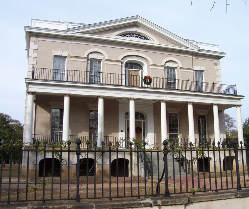
148 listings, 5 of them National Historic Landmarks: 121 buildings, among them the South Carolina State Hospital, Mills Building (a National Historic Landmark since 1973), and the Hampton-Preston House (listed 1969, the first), 23 historic districts with 2,389 contributing buildings, 4 sites, and 1 structure. 2,583 historic buildings in all.
How old are the homes in Columbia?
10% of Columbia’s homes were built before 1940 (Census estimate), against a typical 3.5% for a South Carolina town; the median home was built in 1980.
Founding dates: Wikidata, Wikipedia, the U.S. post office records of Blevins & Helbock (CC0) and the Census. Homes by year built: Census ACS 2020–24. National Register of Historic Places: National Park Service (list of May 22, 2026). Old photos, postcards and papers: Wikimedia Commons, the Library of Congress and other public archives, credited on each item’s page. Maps: U.S. Geological Survey historical topographic maps (via Esri) and Sanborn fire-insurance maps (Library of Congress). History text and census tables: Wikipedia (CC BY-SA 4.0). Places that used to be: USGS Geographic Names Information System (2021).
From Wikimedia Commons (1), the Library of Congress (6), Wikidata (5), the National Register of Historic Places (149), Wikipedia, Wikidata and Wikipedia for famous people, U.S. Census counts (via Wikipedia), the US Post Offices dataset (Blevins & Helbock), the USGS Geographic Names Information System, Sanborn fire insurance maps (Library of Congress) and old county and town histories (Internet Archive). Archive images are copied here with their credits and licenses, shown on each photo’s page. Refreshed monthly.


 ★ Landmark
 ★ Landmark
 ★ Landmark
 ★ Landmark
 ★ Landmark


 1865
 1876
 1903


