West Warwick dates to 1809, and 26% of its homes were built before 1940
More historic than 72% of U.S. towns · #33 of 38 in Rhode Island. What drives it
10 places in town are on the National Register, among them two historic districts with 18 buildings between them. Below: 6 old photos and papers, maps from 1890 on, and the census since 1920.
Founding year: Wikipedia. First post office: 1823.The full story ↓
History grade
What drives West Warwick’s History grade
On its age, its old homes and the National Register, West Warwick is more historic than 72% of U.S. towns, #33 of 38 in Rhode Island. Its share of homes from before 1940 holds the grade up; its National Register listings pull it down.
B+
HistoryA character grade: shown, never part of West Warwick’s overall grade.
Rhode Island towns list more on the Register than most of the country (a typical Rhode Island town has 94.7 per 10,000 residents, the U.S. 2.4), so West Warwick’s 11.2 sits below most of its state (8% of Rhode Island towns have fewer) while its 35 historic buildings outnumber those of 83% of U.S. towns.
NoteThe founding year comes from Wikipedia alone; no second source gives 1809.
How sure. Graded on two of the three inputs, so a change in either one moves the letter more than it would with three. The pre-1940 share is a Census survey estimate (±3.5 points).
Founding year: Wikipedia (other dates in Quick answers). Homes: Census ACS 2020–24. National Register: National Park Service, May 2026 list; each listing counted once (boundary changes and added documentation belong to their listing), and a historic district counts its contributing buildings. How TownRatings grades history →
What stands out about West Warwick’s past
Read from the archive, the National Register and the record. The page puts what stands out first.
Lost post offices, old corners, places now gone and burying grounds
West Warwick’s post office has been open since 1925. Seven other post offices opened and closed inside today’s town.
Centerville
1823–1924
Natick
1828–1925
Lippett
1833–1849
Phenix
1849–1924
River Point
1861–1924
Arctic
1889–1925
Crompton
1893–1924
West Warwick
1925–today
18201920today
Hamlets and corners on the map
ArcticBirch HillCentervilleClydeCromptonHarrisLippittNatickPhenixRiver Point
Gone or out of use
Lippitt MilllocaleValley Queen Milllocale
30family graveyards and cemeteries inside West Warwick
Captain John Waterman LotCenterville MethodistClapp - Greene LotDoctor John McGregor LotEllis - Barney - Sheldon LotEmanual LutheranGeorge Baker LotGeorge Burlingame LotGodfreyGovernor Robert Quinn LotGreene - Anthony LotJohn Tew LotLory Chace LotLucy Tefft LotMajor Peleg Arnold LotNason - Sweet - Spink LotNatickNotre DameNotre Dame Cemetery AnnexOld BaptistOld PhenixOlney B Pierce LotRufus Wakefield LotSaint Joseph'sSaint Mary'sSaint Marys Crompton RectorySaint Philips EpiscopalSnell - Atwood LotThomas Tiffany LotWightman - Sweet Lot
See all 30
Captain John Waterman Lot · Centerville Methodist Cemetery · Clapp - Greene Lot · Doctor John McGregor Lot · Ellis - Barney - Sheldon Lot · Emanual Lutheran Cemetery · George Baker Lot · George Burlingame Lot · Godfrey Cemetery · Governor Robert Quinn Lot · Greene - Anthony Lot · John Tew Lot · Lory Chace Lot · Lucy Tefft Lot · Major Peleg Arnold Lot · Nason - Sweet - Spink Lot · Natick Cemetery · Notre Dame Cemetery · Notre Dame Cemetery Annex · Old Baptist Cemetery · Old Phenix Cemetery · Olney B Pierce Lot · Rufus Wakefield Lot · Saint Joseph's Cemetery · Saint Mary's Cemetery · Saint Marys Crompton Rectory Cemetery · Saint Philips Episcopal Cemetery · Snell - Atwood Lot Cemetery · Thomas Tiffany Lot · Wightman - Sweet Lot
US Post Offices dataset (Blevins & Helbock, CC0). Places and cemeteries from the USGS Geographic Names Information System (2021).
On the map
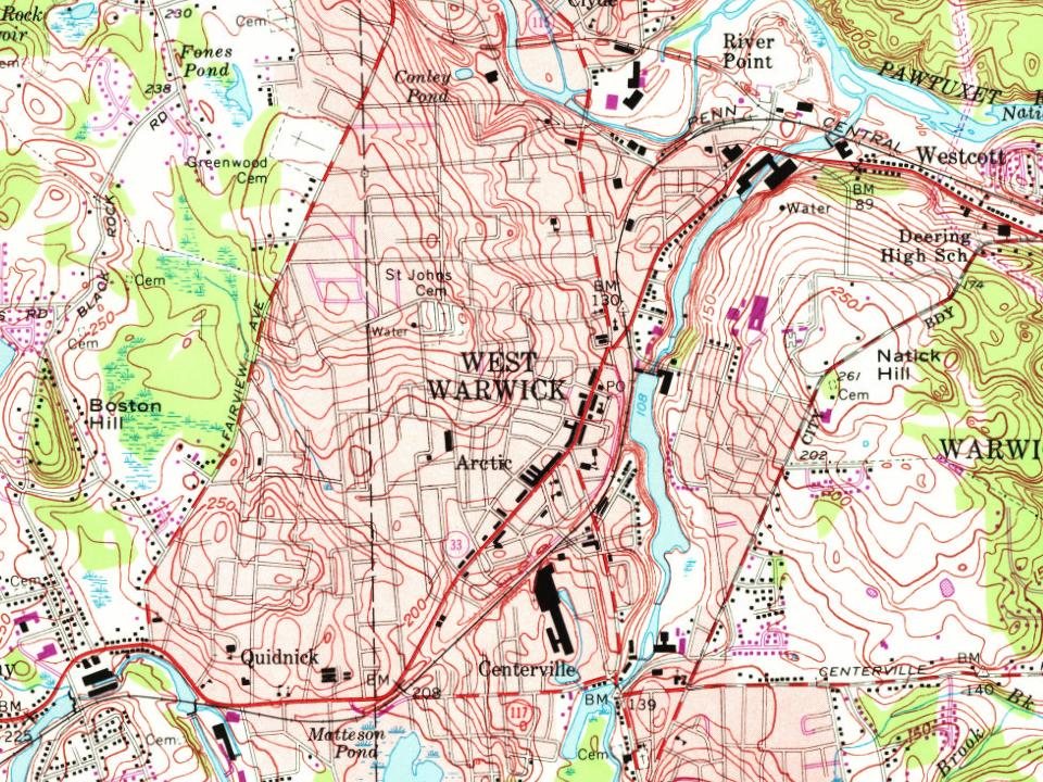
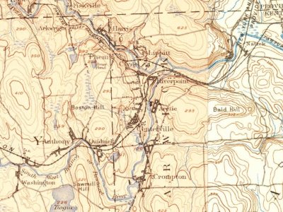
West Warwick on the map, 1890 to 1995
Every edition of the U.S. Geological Survey’s map of West Warwick. Tap a year, or press play to watch the town change.
1890Kent sheet · 1:62,500
U.S. Geological Survey historical topographic maps (public domain), via Esri’s collection of the scans. The red ring marks the center of West Warwick.
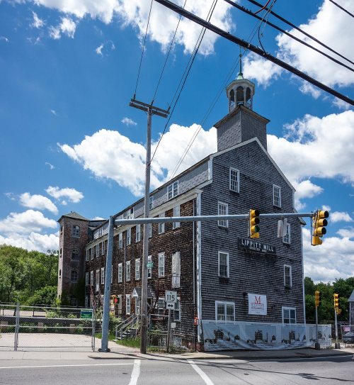
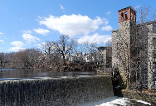
The area that is now the town of West Warwick was the site of some of the earliest textile mills in the United States situated along the banks of the north and south branches of the Pawtuxet River. These small mill villages of the Pawtuxet River Valley would play an important role in the early development of the textile industry in North America. Lippitt Mill, founded in 1809 by Revolutionary War hero Christopher Lippitt, was one of the first mills in the area.
Nothing in the archives for these yearsWeddings on Main Street, storms, parades, school pictures, the old store. If it’s in your family album, it belongs here.
In 1809, according to Wikipedia’s history of the town. West Warwick’s post office opened in 1823, and the census of 1920 counted 15,461 people here.
How does West Warwick rank for history?
West Warwick is more historic than 72% of U.S. towns, #33 of 38 in Rhode Island. The History grade combines the town’s founding era, the share of homes built before 1940 and its National Register listings. It’s a character grade, so it isn’t part of the overall grade. How it works.
What is on the National Register in West Warwick?
10 listings: 8 buildings, among them the Silas Clapp House (listed 1973, the first), and 2 historic districts, the Crompton Mill Historic District and the Arctic Mill Historic District, with 18 contributing buildings. 35 historic buildings in all.
How old are the homes in West Warwick?
26% of West Warwick’s homes were built before 1940 (Census estimate, ±3.5 points), against a typical 20% for a Rhode Island town; the median home was built in 1968.
Founding dates: Wikidata, Wikipedia, the U.S. post office records of Blevins & Helbock (CC0) and the Census. Homes by year built: Census ACS 2020–24. National Register of Historic Places: National Park Service (list of May 22, 2026). Old photos, postcards and papers: Wikimedia Commons, the Library of Congress and other public archives, credited on each item’s page. Maps: U.S. Geological Survey historical topographic maps (via Esri) and Sanborn fire-insurance maps (Library of Congress). History text and census tables: Wikipedia (CC BY-SA 4.0). Places that used to be: USGS Geographic Names Information System (2021).
From Wikimedia Commons (12), the National Register of Historic Places (10), Wikipedia, U.S. Geological Survey historical maps, U.S. Census counts (via Wikipedia), the US Post Offices dataset (Blevins & Helbock) and the USGS Geographic Names Information System. Archive images are copied here with their credits and licenses, shown on each photo’s page. Refreshed monthly.






 1907–1915
 c. 1930
 2016
 2015
 2014
 2013
 2010
 2008