Guest, Sign inJoin

Post to Newport

We’ll email a one-tap link to publish your post. No password, and nothing is public until you click it.
Already a member? Sign in
A+History
History · Newport

Newport dates to 1639, and 58% of its homes were built before 1940

Among the most historic 1% of U.S. towns · #1 of 38 in Rhode Island. What drives it

67 places in town are on the National Register, among them 23 National Historic Landmarks and ten historic districts with 1,847 buildings between them. Below: 3 old photos and papers, maps from 1884 on, and the census since 1790.

1639founded
67on the National Register
58%homes built before 1940
3old photos & papers
49famous people
From Newport’s archive · credits on each photo
Quick answers

How Newport began

When was Newport founded?

1639

Newport dates its founding to 1639 (Wikidata and Wikipedia’s history agree). It appears in the first U.S. census, 1790.

First census: 6,716 in 17902020 census: 25,163387 years

How historic is Newport?

A+

Among the most historic 1% of U.S. towns, on its age, its old homes and the National Register.

What drives the grade ↓
Founding year: Wikidata; Wikipedia’s history section gives the same year. First post office: 1773.The full story ↓
History grade

What drives Newport’s History grade

On its age, its old homes and the National Register, Newport is among the most historic 1% of U.S. towns, #1 of 38 in Rhode Island. All 3 inputs put Newport near the top nationally; its National Register listings ranks highest.

A+
HistoryA character grade: shown, never part of Newport’s overall grade.
All U.S. towns we grade (21,289)Among the top 1%
NewerOlder
Rhode Island towns of 2,500+ (38)#1 of 38

Rhode Island towns list more on the Register than most of the country (a typical Rhode Island town has 94.7 per 10,000 residents, the U.S. 2.4), so Newport’s 769 sits above most of its state (100% of Rhode Island towns have fewer) while its 1,914 historic buildings outnumber those of 99% of U.S. towns.

How sure. Graded on any two of the three inputs instead, the letter would still be A+. The pre-1940 share is a Census survey estimate (±3.0 points). Two sources give 1639.

Founding year: Wikidata (other dates in Quick answers). Homes: Census ACS 2020–24. National Register: National Park Service, May 2026 list; each listing counted once (boundary changes and added documentation belong to their listing), and a historic district counts its contributing buildings. How TownRatings grades history →

What stands out about Newport’s past

Read from the archive, the National Register and the record. The page puts what stands out first.

★ What stands out · On the National Register

67 listings protect 1,914 historic buildings

The country’s official list of buildings and places worth saving. 23 are National Historic Landmarks, the highest tier. Boundary changes and added documentation are counted with their listing.

places listed
67
National Historic Landmarks
23
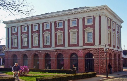
Brick Market
historic buildings protected
1,914
each building in a district counts
first listed
1966
Brick Market
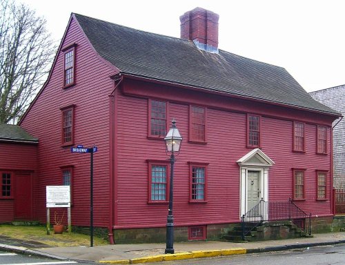
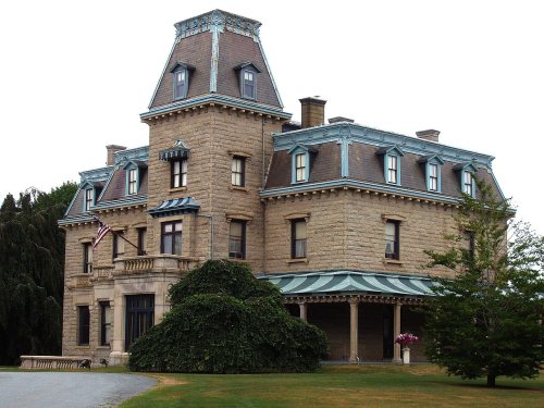
Touro Synagogue National Historic Site, built 1759Miantonomi Memorial ParkClarke Street Meeting HouseCharles H. Baldwin HouseLevi H. Gale House, built 1835Lucas-Johnston HouseSamuel Whitehorne HouseShiloh ChurchDr. Charles Cotton HouseIsaac Bell HousePerry MillCharles Tillinghast HouseNewport Steam FactoryJoseph Rogers HouseWhite Horse TavernEzra Stiles HouseWilliam King Covell III HouseNewport Artillery Company Armory, built 1835Luce Hall, built 1890Bellevue Avenue/Casino Historic DistrictRosecliff, built 1902John Tillinghast House, built 1760Common Burying Ground and Island CemeteryCommandant's Residence, Quarters Number One, Fort Adams, built 1873Ochre Point-Cliffs Historic DistrictFrancis Malbone HouseMalboneBird's Nest, TheCapt. John Mawdsley House, built 1680Seamen's Church Institute of Newport, built 1929Rose Island Lighthouse, built 1870Ida Lewis Rock Lighthouse, built 1854Castle Hill Lighthouse, built 1890Newport Harbor Lighthouse, built 1823Army and Navy YMCAPresident's House, Naval War CollegeEmmanuel Church, built 1900Fort Hamilton Historic DistrictCORONET (Wooden Hull Schooner Yacht)St. Mary's Church ComplexSouthern Thames Historic DistrictKay Street-Catherine Street-Old Beach Road Historic DistrictWEATHERLY (sloop)John Bliss HouseBrick Market★Old Colony House★Redwood Library, built 1747★US Naval War College, built 1884★Wanton-Lyman-Hazard House★Chateau-sur-Mer, built 1851★Hunter House, built 1748★Newport Historic District★Trinity Church★Vernon House★Fort Adams, built 1798★Edward King House★Newport Casino★William Watts Sherman House★Breakers, The, built 1893★Elms, The, built 1899★Marble House★John Griswold House, built 1864★United Congregational Church★Bellevue Avenue Historic District★Kingscote★Ocean Drive Historic District★Isaac Bell Jr. House★
BuildingsDistrictsSitesStructures★ landmark

Architectural styles listings

Colonial Revival10
Greek Revival9
Queen Anne8
Georgian7
Gothic Revival7
Victorian5
All 67 listings
Trinity ChurchBuilding · listed 1968Vernon HouseBuilding · listed 1968Fort AdamsDistrict · listed 1970Edward King HouseBuilding · listed 1970Newport CasinoBuilding · listed 1970William Watts Sherman HouseBuilding · listed 1970Breakers, TheBuilding · listed 1971Elms, TheBuilding · listed 1971Marble HouseBuilding · listed 1971John Griswold HouseBuilding · listed 1971United Congregational ChurchBuilding · listed 1971Bellevue Avenue Historic DistrictDistrict · listed 1972KingscoteBuilding · listed 1973Ocean Drive Historic DistrictDistrict · listed 1976Isaac Bell Jr. HouseBuilding · listed 1997Touro Synagogue National Historic SiteBuilding · listed 1966Miantonomi Memorial ParkSite · listed 1969Clarke Street Meeting HouseBuilding · listed 1971Charles H. Baldwin HouseBuilding · listed 1971Levi H. Gale HouseBuilding · listed 1971Lucas-Johnston HouseBuilding · listed 1971Samuel Whitehorne HouseBuilding · listed 1971Shiloh ChurchBuilding · listed 1971Dr. Charles Cotton HouseBuilding · listed 1972Isaac Bell HouseBuilding · listed 1972Perry MillBuilding · listed 1972Charles Tillinghast HouseBuilding · listed 1972Newport Steam FactoryBuilding · listed 1972Joseph Rogers HouseBuilding · listed 1972White Horse TavernBuilding · listed 1972Ezra Stiles HouseBuilding · listed 1972William King Covell III HouseBuilding · listed 1972Newport Artillery Company ArmoryBuilding · listed 1972Luce HallBuilding · listed 1972Bellevue Avenue/Casino Historic DistrictDistrict · listed 1972RosecliffBuilding · listed 1973John Tillinghast HouseBuilding · listed 1973Common Burying Ground and Island CemeterySite · listed 1974Commandant's Residence, Quarters Number One, Fort AdamsBuilding · listed 1974Ochre Point-Cliffs Historic DistrictDistrict · listed 1975Francis Malbone HouseBuilding · listed 1975MalboneBuilding · listed 1976Bird's Nest, TheBuilding · listed 1982Capt. John Mawdsley HouseBuilding · listed 1983Seamen's Church Institute of NewportBuilding · listed 1983Rose Island LighthouseStructure · listed 1987Ida Lewis Rock LighthouseStructure · listed 1988Castle Hill LighthouseStructure · listed 1988Newport Harbor LighthouseStructure · listed 1988Army and Navy YMCABuilding · listed 1988President's House, Naval War CollegeBuilding · listed 1989Emmanuel ChurchBuilding · listed 1996Fort Hamilton Historic DistrictDistrict · listed 2001CORONET (Wooden Hull Schooner Yacht)Structure · listed 2004St. Mary's Church ComplexBuilding · listed 2008Southern Thames Historic DistrictDistrict · listed 2008Kay Street-Catherine Street-Old Beach Road Historic DistrictDistrict · listed 2018WEATHERLY (sloop)Structure · listed 2012John Bliss HouseBuilding · listed 2025

National Park Service, National Register of Historic Places. Photos from Wikimedia Commons, credited on each place’s page.

Timeline

Newport, 1639 to 1964

Woven from the archive, old maps, post office records, the National Register and the people born here.

  1. 17th century
  2. 1639
    FoundingNewport is established
  3. 18th century
  4. 1747BuiltRedwood Library is built
  5. 1748BuiltHunter House is built
  6. 1773Post officeThe Newport post office opens
  7. 1780Born hereWilliam Ellery Channing is born here
  8. 1794Born hereMatthew C. Perry is born here
  9. 19th century
  10. 1851BuiltChateau-sur-Mer is built
  11. 1858In the archiveThe Baths at Newport title QS:P1476,en:"The Baths at Newport "label QS:Len,"The Baths at …
  12. 1866In the archiveGoat Island Light House
  13. 1884BuiltUS Naval War College is built
  14. 1889On the mapFirst mapped by the U.S. Geological Survey
  15. 20th century
  16. 1916Born hereVan Johnson is born here
  17. 1960LandmarkBrick Market named a National Historic Landmark
  18. 1960LandmarkOld Colony House named a National Historic Landmark
  19. 1960LandmarkRedwood Library named a National Historic Landmark
  20. 1960LandmarkWanton-Lyman-Hazard House named a National Historic Landmark
  21. 1960CensusPopulation peaks at 47,049
  22. 1964LandmarkUS Naval War College named a National Historic Landmark
The story

How Newport came to be

From Wikipedia’s history of Newport.

Read it all →

Newport was founded in 1639 on Rhode Island, which is now called Aquidneck Island. Its eight founders and first officers were Nicholas Easton, William Coddington, John Clarke, John Coggeshall, William Brenton, Jeremy Clark, Thomas Hazard, and Henry Bull. Many of these people were part of the settlement at Portsmouth, along with Anne Hutchinson and her followers. They separated within a year of settling Portsmouth and began the settlement of Newport on the southern side of the island.

Text from Wikipedia, licensed CC BY-SA 4.0.

From the old history books

What they wrote about Newport in 1880

Passages that mention Newport, cut from the printed page as they were published.

Although settled in 1639, it was not until 1705, that Newport was authorized to regulate its own prudential affairs by any act of the colony, at that time Newport included what is now the town of Middletown, which latter was known as “the woods.” In 1742 “the freeholders of the woods part of the to…
The Newport historical magazine1880 · page 224Read the page →
Read the text

Although settled in 1639, it was not until 1705, that Newport was authorized to regulate its own prudential affairs by any act of the colony, at that time Newport included what is now the town of Middletown, which latter was known as “the woods.” In 1742 “the freeholders of the woods part of the town of Newport, did by petition set forth that the town of Newport is very large, consisting of a vast number of inhabitants, and of freemen, upwards

Text read by machine from the scan; it may contain errors.
“The Deposition of John Odlin, of Newport, of sixty-two 5'eai'3 of age, on oath sayeth that he knoweth that point of land called Aquidneck Point in the town of Newport, which Job Carr is in possession of a part thereof, and is sued for by Jonathan Marsh, and doth know very well that the town of New…
The Newport historical magazine1880 · page 251Read the page →
Read the text

“The Deposition of John Odlin, of Newport, of sixty-two 5'eai'3 of age, on oath sayeth that he knoweth that point of land called Aquidneck Point in the town of Newport, which Job Carr is in possession of a part thereof, and is sued for by Jonathan Marsh, and doth know very well that the town of Newport hath improved it in their own rights for above thirty 3'ears by fetching of land for

Text read by machine from the scan; it may contain errors.

Scans and text from the Internet Archive. Books published in 1930 or earlier, which are in the public domain.

By decade

Newport, decade by decade

2 decades in the archive, from the 1850s to the 1860s. Scroll each row; tap a photo for its story.

On the map

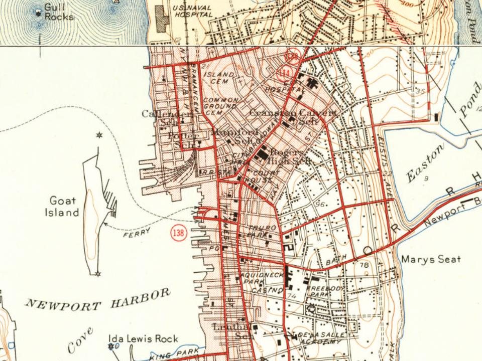
Newport on the map, 1889 to 1970

Every edition of the U.S. Geological Survey’s map of Newport. Tap a year, or press play to watch the town change.

Newport on the 1889 USGS mapNewport on the 1894 USGS mapNewport on the 1904 USGS mapNewport on the 1920 USGS mapNewport on the 1939 USGS mapNewport on the 1944 USGS mapNewport on the 1957 USGS mapNewport on the 1970 USGS map1889Newport sheet · 1:62,500

U.S. Geological Survey historical topographic maps (public domain), via Esri’s collection of the scans. The red ring marks the center of Newport.

Every building

Newport, building by building, 1884–1921

Fire insurance maps drew every building, what it was made of and what it was used for, so insurers could price the risk of fire. Pick a year, then a sheet.

Newport fire insurance map, 1884, sheet 11884Sheet 1 of 15
Edition
BrickWoodStone

Sanborn Map Company, via the Library of Congress. Editions published in 1930 or earlier, which are in the public domain.

Then & now

The same spot, years apart

Drag across each photo to compare.

Newport Harbor LightGoat Island Light House1866Today
Goat Island Light HouseMatched from the two captions
People over time

Newport, census by census

05,00010,00015,00020,00025,00030,00035,00040,00045,00050,00018001850190019502000Peak: 47,049

Peaked at 47,049 in 1960; 25,163 people lived here in 2020.

24 censuses, 1790–2020.

U.S. Census Bureau decennial counts, from the census table on Newport’s Wikipedia page.

Famous people

49 famous people were born in Newport

Writers, athletes, leaders and more, ranked by how widely they’re known.

See all →
Places that used to be

Old corners, places now gone and burying grounds

Newport’s post office has been open since 1773.

Hamlets and corners on the map
Brenton Village
Gone or out of use
Banisters WharflocaleEdward King HousebuildingEllerys Ferry WharflocaleGardners WharflocaleGull Rocks LightlocaleIda Lewis Rock LightlocaleLopezs WharflocaleMaltbones WharflocaleNaval Training Station NewportmilitaryNewport Artillery Company ArmorymilitaryOverings WharflocalePeases WharflocalePerry MilllocaleRedwoods WharflocaleRomes WharflocaleRose Island LightlocaleSlocums WharflocaleTaylors Wharflocale
9cemeteries and burying grounds inside Newport
ArnoldBramanCoddingtonColonial JewishCommon Burial GroundIslandOld CitySaint MarysTrinity Churchyard

US Post Offices dataset (Blevins & Helbock, CC0). Places and cemeteries from the USGS Geographic Names Information System (2021).

Help out

Start Newport’s collection

The first neighbors to add old photos shape how Newport’s history is told.

Decades since 1900 with photos
00s10s20s30s40s50s60s70s80s90s
0 of 10 decades. The empty ones are waiting for someone’s album.
Stories next door

History across the town line

Each neighbor’s History grade, on the same three inputs.

Questions about Newport’s history

What year was Newport founded?

In 1639, according to Wikidata and Wikipedia’s history of the town. Newport’s post office opened in 1773, and the first U.S. census counted 6,716 people here in 1790.

How does Newport rank for history?

Newport is among the most historic 1% of U.S. towns, #1 of 38 in Rhode Island. The History grade combines the town’s founding era, the share of homes built before 1940 and its National Register listings. It’s a character grade, so it isn’t part of the overall grade. How it works.

What is on the National Register in Newport?

67 listings, 23 of them National Historic Landmarks: 49 buildings, among them the Brick Market (a National Historic Landmark since 1960), 10 historic districts with 1,847 contributing buildings, 2 sites, and 6 structures. 1,914 historic buildings in all.

How old are the homes in Newport?

58% of Newport’s homes were built before 1940 (Census estimate, ±3.0 points), against a typical 20% for a Rhode Island town; the median home was built in 1938.

Memory lane

What the archives can’t tell you, neighbors can.

Town Square →
Start a conversation
Sources

Where this page comes from

Founding dates: Wikidata, Wikipedia, the U.S. post office records of Blevins & Helbock (CC0) and the Census. Homes by year built: Census ACS 2020–24. National Register of Historic Places: National Park Service (list of May 22, 2026). Old photos, postcards and papers: Wikimedia Commons, the Library of Congress and other public archives, credited on each item’s page. Maps: U.S. Geological Survey historical topographic maps (via Esri) and Sanborn fire-insurance maps (Library of Congress). History text and census tables: Wikipedia (CC BY-SA 4.0). Places that used to be: USGS Geographic Names Information System (2021).

From Wikimedia Commons (2), the Library of Congress (1), Wikidata (13), the National Register of Historic Places (67), Wikipedia, Wikidata and Wikipedia for famous people, U.S. Geological Survey historical maps, U.S. Census counts (via Wikipedia), the US Post Offices dataset (Blevins & Helbock), the USGS Geographic Names Information System, Sanborn fire insurance maps (Library of Congress) and old county and town histories (Internet Archive). Archive images are copied here with their credits and licenses, shown on each photo’s page. Refreshed monthly.