Guest, Sign inJoin

Post to Wilkes-Barre

We’ll email a one-tap link to publish your post. No password, and nothing is public until you click it.
Already a member? Sign in
A+History
History · Wilkes-Barre

Wilkes-Barre dates to 1769, and 47% of its homes were built before 1940

Among the most historic 1% of U.S. towns · #25 of 1,035 in Pennsylvania. What drives it

17 places in town are on the National Register, among them a historic district with 215 buildings. Below: 10 old photos and papers, maps from 1891 on, and the census since 1800.

1769founded
17on the National Register
47%homes built before 1940
10old photos & papers
40famous people
From Wilkes-Barre’s archive · credits on each photo
Quick answers

How Wilkes-Barre began

When was Wilkes-Barre founded?

1769

Wilkes-Barre dates its founding to 1769 (Wikidata and Wikipedia’s history agree). The census first counted it in 1800.

First census: 835 in 18002020 census: 44,328257 years

How historic is Wilkes-Barre?

A+

Among the most historic 1% of U.S. towns, on its age, its old homes and the National Register.

What drives the grade ↓
Founding year: Wikidata; Wikipedia’s history section gives the same year. First post office: 1795.The full story ↓
History grade

What drives Wilkes-Barre’s History grade

On its age, its old homes and the National Register, Wilkes-Barre is among the most historic 1% of U.S. towns, #25 of 1,035 in Pennsylvania. All 3 inputs put Wilkes-Barre near the top nationally; its share of homes from before 1940 ranks highest.

A+
HistoryA character grade: shown, never part of Wilkes-Barre’s overall grade.
All U.S. towns we grade (21,289)Among the top 1%
NewerOlder
Pennsylvania towns of 2,500+ (1,035)Ahead of 98%

Pennsylvania towns list about as much on the Register as the country (a typical Pennsylvania town has 2.1 per 10,000 residents, the U.S. 2.4), so Wilkes-Barre’s 52.7 sits above most of its state (86% of Pennsylvania towns have fewer) while its 234 historic buildings outnumber those of 94% of U.S. towns.

How sure. Graded on any two of the three inputs instead, the letter would still be A+. The pre-1940 share is a Census survey estimate (±3.2 points). Two sources give 1769.

Founding year: Wikidata (other dates in Quick answers). Homes: Census ACS 2020–24. National Register: National Park Service, May 2026 list; each listing counted once (boundary changes and added documentation belong to their listing), and a historic district counts its contributing buildings. How TownRatings grades history →

What stands out about Wilkes-Barre’s past

Read from the archive, the National Register and the record. The page puts what stands out first.

★ What stands out · On the National Register

17 listings protect 234 historic buildings

The country’s official list of buildings and places worth saving.

places listed
17
National Historic Landmarks
0
none yet
historic buildings protected
234
each building in a district counts
first listed
1972
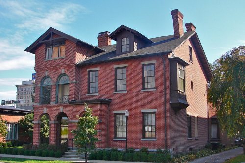
Catlin Hall, Wilkes College
All 17 listings

National Park Service, National Register of Historic Places. Photos from Wikimedia Commons, credited on each place’s page.

On the map

Wilkes-Barre on the map, 1891 to 1976

Every edition of the U.S. Geological Survey’s map of Wilkes-Barre. Tap a year, or press play to watch the town change.

Wilkes-Barre on the 1891 USGS mapWilkes-Barre on the 1947 USGS mapWilkes-Barre on the 1950 USGS mapWilkes-Barre on the 1969 USGS mapWilkes-Barre on the 1976 USGS map1891Wilkes-Barre sheet · 1:62,500

U.S. Geological Survey historical topographic maps (public domain), via Esri’s collection of the scans. The red ring marks the center of Wilkes-Barre.

The story

How Wilkes-Barre came to be

From Wikipedia’s history of Wilkes-Barre.

Read it all →

For thousands of years, nomadic bands of hunter-gatherers used the Wilkes-Barre area for hunting, fishing, foraging, and toolmaking. Numerous artifacts from the Archaic period (about 8000–1200 BC), including stone spear points, net weights, and scrapers have been found in the area. Pottery and arrowheads from the Early and Middle Woodland periods (c. 1200 BC–950 AD) have also been found. In the Late Woodland period (c. 950–1550 AD), horticulture was adopted and more permanent settlements were established in the Wyoming Valley.

Text from Wikipedia, licensed CC BY-SA 4.0.

From the old history books

What they wrote about Wilkes-Barre in 1885

Passages that mention Wilkes-Barre, cut from the printed page as they were published.

"March ye 2nd, 1774, this meeting is opened and held by adjournment. Voted that ye town of Westmoreland be divided in the following manner into districts — that is to say: — That ye town of Wilkes-Barre be one entire district, and known by the name of Wilkes-Barre District. And that ye town of Hano…
History of Hanover Township1885 · page 84Read the page →
Read the text

"March ye 2nd, 1774, this meeting is opened and held by adjournment. Voted that ye town of Westmoreland be divided in the following manner into districts — that is to say: — That ye town of Wilkes-Barre be one entire district, and known by the name of Wilkes-Barre District. And that ye town of Hanover, and all the land south of Wilkes-Barre, and west on the Susquehanna river, and east on the Lehigh, be one district by the name of Hanover District. And that Plymouth with all ye land west of

Text read by machine from the scan; it may contain errors.

Scans and text from the Internet Archive. Books published in 1930 or earlier, which are in the public domain.

Timeline

Wilkes-Barre, 1769 to 1923

Woven from the archive, old maps, post office records, the National Register and the people born here.

  1. 18th century
  2. 1769
    FoundingWilkes-Barre is established
  3. 1795Post officeThe Wilkesbarre post office opens
  4. 19th century
  5. 1840In the archiveWilkesbarre (Vale of Wyoming)
  6. 1860In the archiveWilkesbarre, seen from Bowman’s Hill.Alternate Title: Stereoscopic views of Wilkes-Barre,…
  7. 1872Post officeThe Parsons post office opens
  8. 1874BuiltMemorial Presbyterian Church is built
  9. 1884Post officeThe Miners Mills post office opens
  10. 1889In the archiveWilkes-Barre 1889
  11. 1891On the mapFirst mapped by the U.S. Geological Survey
  12. 1894BuiltStegmaier Brewery is built
  13. 1897In the archiveMartin proclamation LattimerMassacre
  14. 20th century
  15. 1905In the archiveMurgas radiotelegraph station at Wilkes-Barre, Pennsylvania (1905)
  16. 1909Born hereJoseph L. Mankiewicz is born here
  17. 1912Post officeThe Parsons post office closes
  18. 1912Post officeThe Miners Mills post office closes
  19. 1917Born hereDavid Bohm is born here
  20. 1918Born hereEdward B. Lewis is born here
  21. 1923BuiltKingston Armory is built
By decade

Wilkes-Barre, decade by decade

5 decades in the archive, from the 1840s to the 1900s. Scroll each row; tap a photo for its story.

Then & now

Stand where they stood

No then-and-now pairs yet. Take a photo from the same spot as an old one and they appear here side by side.

Wilkesbarre (Vale of Wyoming)
Retake this viewWilkesbarre (Vale of Wyoming), 1840

Find the spot, match the angle, and add your photo. It becomes the first then-and-now pair on Wilkes-Barre’s page.

Retake this view · +15
People over time

Wilkes-Barre, census by census

020,00040,00060,00080,00018001850190019502000Peak: 86,626

Peaked at 86,626 in 1930; 44,328 people lived here in 2020.

22 censuses, 1800–2020.

U.S. Census Bureau decennial counts, from the census table on Wilkes-Barre’s Wikipedia page.

Famous people

40 famous people were born in Wilkes-Barre

Writers, athletes, leaders and more, ranked by how widely they’re known.

See all →
Places that used to be

Lost post offices, old corners and burying grounds

Two other post offices opened and closed inside today’s town.

Wilkesbarre
1795–today
Parsons
1872–1912
Miners Mills
1884–1912
17901910today
Hamlets and corners on the map
Miners MillsNewtonParsons
6cemeteries and burying grounds inside Wilkes-Barre
B'Nai JacobHollenbackMallinckrodt ConventSaint NicholasSaint Nicholas Church ColumbariumWilkes - Barre City

US Post Offices dataset (Blevins & Helbock, CC0). Places and cemeteries from the USGS Geographic Names Information System (2021).

Help out

Finish Wilkes-Barre’s story

Most archives stop around 1920. The photos from after that are in family albums, not libraries.

Decades since 1900 with photos
00s10s20s30s40s50s60s70s80s90s
1 of 10 decades. The empty ones are waiting for someone’s album.
Stories next door

History across the town line

Each neighbor’s History grade, on the same three inputs.

Questions about Wilkes-Barre’s history

What year was Wilkes-Barre founded?

In 1769, according to Wikidata and Wikipedia’s history of the town. Wilkes-Barre’s post office opened in 1795, and the census of 1800 counted 835 people here.

How does Wilkes-Barre rank for history?

Wilkes-Barre is among the most historic 1% of U.S. towns, #25 of 1,035 in Pennsylvania. The History grade combines the town’s founding era, the share of homes built before 1940 and its National Register listings. It’s a character grade, so it isn’t part of the overall grade. How it works.

What is on the National Register in Wilkes-Barre?

17 listings: 14 buildings, among them the Catlin Hall, Wilkes College (listed 1972, the first), 1 historic district, the River Street Historic District, with 215 contributing buildings, and 2 structures. 234 historic buildings in all.

How old are the homes in Wilkes-Barre?

47% of Wilkes-Barre’s homes were built before 1940 (Census estimate, ±3.2 points), against a typical 18% for a Pennsylvania town; the median home was built in 1943.

Memory lane

What the archives can’t tell you, neighbors can.

Town Square →
Start a conversation
Sources

Where this page comes from

Founding dates: Wikidata, Wikipedia, the U.S. post office records of Blevins & Helbock (CC0) and the Census. Homes by year built: Census ACS 2020–24. National Register of Historic Places: National Park Service (list of May 22, 2026). Old photos, postcards and papers: Wikimedia Commons, the Library of Congress and other public archives, credited on each item’s page. Maps: U.S. Geological Survey historical topographic maps (via Esri) and Sanborn fire-insurance maps (Library of Congress). History text and census tables: Wikipedia (CC BY-SA 4.0). Places that used to be: USGS Geographic Names Information System (2021).

From Wikimedia Commons (10), Wikidata (2), the National Register of Historic Places (17), Wikipedia, Wikidata and Wikipedia for famous people, U.S. Geological Survey historical maps, U.S. Census counts (via Wikipedia), the US Post Offices dataset (Blevins & Helbock), the USGS Geographic Names Information System and old county and town histories (Internet Archive). Archive images are copied here with their credits and licenses, shown on each photo’s page. Refreshed monthly.