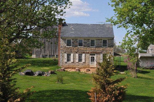
Manheim Township dates to 1762, and 7 of its places are on the National Register
More historic than 83% of U.S. towns · #276 of 1,035 in Pennsylvania. What drives it
Most of Manheim Township was built recently: 8% of its homes predate 1940 and the median home dates from 1979. 7 places in town are on the National Register, among them two historic districts with 16 buildings between them. Below: 12 old photos and papers, maps from 1902 on, and the census since 1850.
Founding year: Wikidata; Wikipedia’s history section gives the same year. First post office: 1775.The full story ↓
History grade
What drives Manheim Township’s History grade
On its age, its old homes and the National Register, Manheim Township is more historic than 83% of U.S. towns, #276 of 1,035 in Pennsylvania. Its age holds the grade up; its share of homes from before 1940 pulls it down.
A−
HistoryA character grade: shown, never part of Manheim Township’s overall grade.
Pennsylvania towns list about as much on the Register as the country (a typical Pennsylvania town has 2.1 per 10,000 residents, the U.S. 2.4), so Manheim Township’s 6.3 sits above most of its state (70% of Pennsylvania towns have fewer) while its 28 historic buildings outnumber those of 81% of U.S. towns.
How sure. Graded on any two of the three inputs instead, the letter would range from B to A+. The pre-1940 share (±2.2 points) is firm at this size. Two sources give 1762.
Founding year: Wikidata (other dates in Quick answers). Homes: Census ACS 2020–24. National Register: National Park Service, May 2026 list; each listing counted once (boundary changes and added documentation belong to their listing), and a historic district counts its contributing buildings. How TownRatings grades history →
What stands out about Manheim Township’s past
Read from the archive, the National Register and the record. The page puts what stands out first.
Lost post offices, old corners, places now gone and burying grounds
Four other post offices opened and closed inside today’s town.
Lancaster
1775–today
Manheim
1815–today
Neffsville
1829–1971
Binkleys Bridge
1850–1895
Landis Vallev
1857–1913
Rossmere
1900–1909
17701900today
Hamlets and corners on the map
Beverly EstatesBloomingdaleBlossom HillBrooklawnClearviewCountry Club HeightsEdenEden HeightsFruitvilleGlen MooreGrandview HeightsHomelandKenwick VillageLandis ValleyNeffsvilleOregonPenn Rose ParkRosevilleRossmereShreiners
Gone or out of use
Binkleys Bridge Post Officepost officeFruitville QuarrymineManheim Post Officepost office
27family graveyards and cemeteries inside Manheim Township
BasslerBuchBuch FamilyEdward S HessFrick - On Hoover FarmGrace United Church of Christ Memorial GardenHighland Presbyterian Memorial GardenHostetter GravesJohnsonKurtzLancaster Church of the Brethren Memorial GardenLandisLandis Valley MennoniteLong - LandisLong Memorial United MethodistMayerNeffsville Church of the BrethrenNeffsville LutheranOregon Community United MethodistRohrer HersheySaint Andrew Ukrainian Catholic ChurchSaint Matthew Evangelical Lutheran Memorial GardenSaint Thomas Episcopal Church Memorial GardenShaurai ShomayimStemanStoner / SteinerWestminster Presbyterian
See all 27
Bassler Graveyard · Buch Cemetery · Buch Family Cemetery · Edward S Hess Cemetery · Frick - On Hoover Farm Cemetery · Grace United Church of Christ Memorial Garden · Highland Presbyterian Memorial Garden · Hostetter Graves · Johnson Graveyard · Kurtz Burying Ground · Lancaster Church of the Brethren Memorial Garden · Landis Cemetery · Landis Valley Mennonite Cemetery · Long - Landis Cemetery · Long Memorial United Methodist Cemetery · Mayer Graveyard · Neffsville Church of the Brethren Cemetery · Neffsville Lutheran Cemetery · Oregon Community United Methodist Cemetery · Rohrer Hershey Cemetery · Saint Andrew Ukrainian Catholic Church Cemetery · Saint Matthew Evangelical Lutheran Memorial Garden · Saint Thomas Episcopal Church Memorial Garden · Shaurai Shomayim Cemetery · Steman Cemetery · Stoner / Steiner Cemetery · Westminster Presbyterian Cemetery
US Post Offices dataset (Blevins & Helbock, CC0). Places and cemeteries from the USGS Geographic Names Information System (2021).
On the map
Manheim Township on the map, 1902 to 1995
Every edition of the U.S. Geological Survey’s map of Manheim Township. Tap a year, or press play to watch the town change.
1902Lancaster sheet · 1:62,500
U.S. Geological Survey historical topographic maps (public domain), via Esri’s collection of the scans. The red ring marks the center of Manheim Township.
Manheim was laid out by Henry William Stiegel in 1762 on a land tract in Rapho Township, though it was only incorporated in 1838. He set out to build an industrial empire and founded the Manheim Glassworks. After financial failure, he was forced to sell the development in 1775. After several failed attempts at resurrecting the glassworks, it closed in 1780.
The first railroad train came into Manheim on January 1, 1862, with the completion of the first division of the Columbia and Reading Railroad. In 1884, another forward step was the laying of water pipes and the beginning of service by the Manheim Electric Company, which set up a plant in Bomberger's Mill at the end of Mill Street.
Nothing in the archives for these yearsWeddings on Main Street, storms, parades, school pictures, the old store. If it’s in your family album, it belongs here.
In 1762, according to Wikidata and Wikipedia’s history of the town. Manheim Township’s post office opened in 1775, and the census of 1850 counted 778 people here.
How does Manheim Township rank for history?
Manheim Township is more historic than 83% of U.S. towns, #276 of 1,035 in Pennsylvania. The History grade combines the town’s founding era, the share of homes built before 1940 and its National Register listings. It’s a character grade, so it isn’t part of the overall grade. How it works.
What is on the National Register in Manheim Township?
7 listings: 4 buildings, 2 historic districts, the Shreiner Farm and the Landis Valley Museum, with 16 contributing buildings, and 1 structure. 28 historic buildings in all.
How old are the homes in Manheim Township?
8% of Manheim Township’s homes were built before 1940 (Census estimate, ±2.2 points), against a typical 18% for a Pennsylvania town; the median home was built in 1979.
Founding dates: Wikidata, Wikipedia, the U.S. post office records of Blevins & Helbock (CC0) and the Census. Homes by year built: Census ACS 2020–24. National Register of Historic Places: National Park Service (list of May 22, 2026). Old photos, postcards and papers: Wikimedia Commons, the Library of Congress and other public archives, credited on each item’s page. Maps: U.S. Geological Survey historical topographic maps (via Esri) and Sanborn fire-insurance maps (Library of Congress). History text and census tables: Wikipedia (CC BY-SA 4.0). Places that used to be: USGS Geographic Names Information System (2021).
From Wikimedia Commons (11), the Library of Congress (1), the National Register of Historic Places (7), Wikipedia, U.S. Geological Survey historical maps, U.S. Census counts (via Wikipedia), the US Post Offices dataset (Blevins & Helbock) and the USGS Geographic Names Information System. Archive images are copied here with their credits and licenses, shown on each photo’s page. Refreshed monthly.


 1933
 1942
 1942
 1942
 1942
 1942