The Groveport post office opened in 1847, the earliest record of the town by name. Two smaller post offices, Oregon (1831) and Werts Grove (1834), opened inside today’s city and later closed.
First census: 483 in 18502020 census: 6,009179 years
How historic is Groveport?
A
More historic than 87% of U.S. towns, on its age, its old homes and the National Register.
Founding year: the first Groveport post office (Blevins & Helbock, CC0).The full story ↓
History grade
What drives Groveport’s History grade
On its age, its old homes and the National Register, Groveport is more historic than 87% of U.S. towns, #201 of 993 in Ohio. All 3 inputs are above most U.S. towns; its National Register listings ranks highest and its share of homes from before 1940 lowest.
A
HistoryA character grade: shown, never part of Groveport’s overall grade.
Ohio towns list about as much on the Register as the country (a typical Ohio town has 2.9 per 10,000 residents, the U.S. 2.4), so Groveport’s 16.9 sits above most of its state (80% of Ohio towns have fewer) while its 10 historic buildings outnumber those of 76% of U.S. towns.
How sure. Graded on any two of the three inputs instead, the letter would still be A−. The pre-1940 share is a Census survey estimate (±7.7 points). The founding year is the first post office, not a stated founding date.
Founding year: the first post office (other dates in Quick answers). Homes: Census ACS 2020–24. National Register: National Park Service, May 2026 list; each listing counted once (boundary changes and added documentation belong to their listing), and a historic district counts its contributing buildings. How TownRatings grades history →
What stands out about Groveport’s past
Read from the archive, the National Register and the record. The page puts what stands out first.
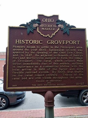
Groveport had its start as a single entity in 1846 when the neighboring rival towns of Wert's Grove and Rarey's Port merged. These towns were located along the Ohio and Erie Canal. The city was incorporated as a village in 1847. A post office called Groveport has been in operation since 1847. The city is the location of the Groveport Log House, which was built in 1815 and moved in 1974 to a location near Groveport Cemetery.
Passages that mention Groveport, cut from the printed page as they were published.
History of Madison Township, including Groveport and Canal Winchester, Franklin County, Ohio1902 · page 257Read the page →
Read the text
More or less interest continued until the spring of 1864, when the Mineral Railroad was incorporated and surveyed. This survey went over two routes ; the one north of Asbury and the other by way of Groveport. In the winter of 1865-66 the agitation became active again and Winchester raised a subscription of $30,000.00 and Groveport one of $25,000.00.
Text read by machine from the scan; it may contain errors.
History of Madison Township, including Groveport and Canal Winchester, Franklin County, Ohio1902 · page 214Read the page →
Read the text
The following is a list of the officers of the village of Groveport. The date shows year of election. One of the record books, 1870 to 1877, could not be found, hence the omission of some names : Mayors: A. Shoemaker, 1847- 1848, Henry Long, 1849, 1866; Z. P. Thompson, 1850, 1851, 1855, 1856, Digitized by Google
Text read by machine from the scan; it may contain errors.
Centennial history of Columbus and Franklin County, Ohio1909 · page 636Read the page →
Read the text
the Hayden Run bridge over the Scioto river, the Fishinger Mill bridge over the Scioto river, the Taylor bridge over the Big Walnut and Alum creeks in Madison township, the Cleveland avenue viaduct, the Reed avenue viaduct, the Joyce avenue viaduct, the Groveport pike subway, and is now completing the Leonard avenue viaduc. His work in this connection has attracted the
Text read by machine from the scan; it may contain errors.
History of Franklin County [Ohio]1858 · page 210Read the page →
Read the text
side of Madison Township, in 1851, threw the town of Winchester, which had previously been in Fairfield County, into this. Winchester, like Groveport, is situated on the canal, and is a place of very considerable business, particularly in grain and produce. In its business generally, it bears a similarity to Groveport, though it is a much older town. It was laid out about the year 1826 or '27, by Reuben Dove and John Coleman, of
Text read by machine from the scan; it may contain errors.
Scans and text from the Internet Archive. Books published in 1930 or earlier, which are in the public domain.
The Groveport post office opened in 1847, the earliest record of the town by name (U.S. post office records).
How does Groveport rank for history?
Groveport is more historic than 87% of U.S. towns, #201 of 993 in Ohio. The History grade combines the town’s founding era, the share of homes built before 1940 and its National Register listings. It’s a character grade, so it isn’t part of the overall grade. How it works.
What is on the National Register in Groveport?
4 listings: 4 buildings, among them the Groveport Log Houses (listed 1976, the first). 10 historic buildings in all.
How old are the homes in Groveport?
20% of Groveport’s homes were built before 1940 (Census estimate, ±7.7 points), against a typical 15% for an Ohio town; the median home was built in 1990.
Founding dates: Wikidata, Wikipedia, the U.S. post office records of Blevins & Helbock (CC0) and the Census. Homes by year built: Census ACS 2020–24. National Register of Historic Places: National Park Service (list of May 22, 2026). Old photos, postcards and papers: Wikimedia Commons, the Library of Congress and other public archives, credited on each item’s page. Maps: U.S. Geological Survey historical topographic maps (via Esri) and Sanborn fire-insurance maps (Library of Congress). History text and census tables: Wikipedia (CC BY-SA 4.0). Places that used to be: USGS Geographic Names Information System (2021).
From Wikimedia Commons (5), the National Register of Historic Places (4), Wikipedia, Wikidata and Wikipedia for famous people, U.S. Geological Survey historical maps, U.S. Census counts (via Wikipedia), the US Post Offices dataset (Blevins & Helbock), the USGS Geographic Names Information System, Sanborn fire insurance maps (Library of Congress) and old county and town histories (Internet Archive). Archive images are copied here with their credits and licenses, shown on each photo’s page. Refreshed monthly.


 2024
 2024
 2024
 2021
 2021


