238 years in pictures
Census counts: 1,958 in 1820, 2,220 in 2010. The archive holds 18 old photos and papers going back to 2004 and a map from 1985 on.
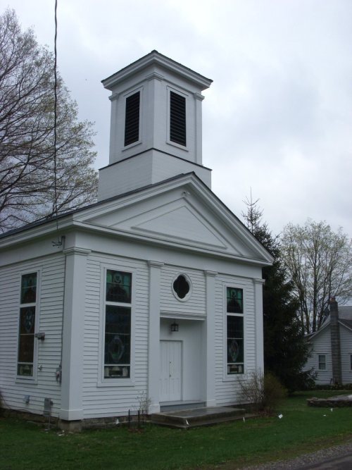
2 places on the National Register of Historic Places.
- 1788Worcester is settled
Each edition grades its towns against each other only.

Home to 2 places on the National Register of Historic Places.
Worcester’s best subject grades are an A+ for history and an A− for civic life; its weakest is a D for schools. Its National Register listings include Worcester Historic District and South Worcester Historic District. Worcester has fewer than 2,500 residents, so it gets subject grades but no overall grade.
Where Worcester beats most towns, and one thing worth knowing.
Worcester Historic District| School | Grades | Students |
|---|---|---|
| Worcester School | K–12 | 308 |
Census counts: 1,958 in 1820, 2,220 in 2010. The archive holds 18 old photos and papers going back to 2004 and a map from 1985 on.
2 places on the National Register of Historic Places.
Each subject compared with towns across the country (schools within New York), ordered by how far Worcester is from typical.
How TownRatings grades towns →
Who provides power, water and the rest in Worcester, and how to reach them.
EPA SDWIS (Oct 9, 2026) · HIFLD + EIA-861 2025 · Census 2020 ZCTAs · NCES 2024–25 · registration: vote.gov, updated Aug 3, 2026.
Ordered by what stands out in Worcester.
The public schools here belong to the Worcester Central School District. The largest public high school is Worcester School, with 308 students. Its one school is below.
| School | Level | Students | Letter |
|---|---|---|---|
| Worcester SchoolLargest public high schoolGrades K–12 | Grades K–12 | 308 | C− |
NCES · EDFacts · graded within NY on state tests and graduation
Federal aid has come to Worcester households in 9 declared disasters; the latest was in 2017. Expected losses in Worcester break down as 84% from inland flooding and 9% from cold waves. Paid flood insurance claims in the town since 2006: 5.
FEMA disaster declarations and aid · FEMA flood insurance claims · FEMA National Risk Index · OpenFEMA
In Worcester, 13% of working residents work locally, against 10% in New York’s towns and 8% across U.S. towns. Among residents in the town, 22% live below the poverty line. Half commute less than 24 miles. The top destinations are Otsego (7%), Oneonta (7%) and New York (6%).
| Worcester | New York towns | U.S. towns | |
|---|---|---|---|
| Below the poverty line | 22% | 9.5% | 9.6% |
| Median household income | $70,000 | $82,000 | $80,000 |
| Working residents who work in town | 13% | 10% | 8% |
| Average trip to work | 26 minutes | 25 minutes | 25 minutes |
Census LEHD 2023 · ACS
Summers in Worcester are pleasant, and winters cold, snowy. July afternoons reach 77°, January nights drop to 12° and about 83 inches of snow falls in a winter.
NOAA U.S. Climate Normals, 1991–2020
Worcester: 15% of adults report frequent physical distress. Against the New York average, Worcester comes out ahead on 8 CDC measures out of 32, and behind on 9. Among adults in the town, 38% have high blood pressure and 13% have diabetes.
| Worcester | New York towns | U.S. towns | |
|---|---|---|---|
| Frequent physical distress (CDC PLACES) | 15% | 14% | 14% |
| High blood pressure (CDC PLACES) | 38% | 34% | 35% |
| Diabetes (CDC PLACES) | 13% | 11% | 12% |
| Depression (CDC PLACES) | 20% | 21% | 23% |
| What stands out | Worcester | NY |
|---|---|---|
| Fewer uninsured adults | 5.7% | 7.9% |
| Fewer adults facing food insecurity | 12.6% | 17.2% |
| More adults with COPD | 8.7% | 6% |
CDC PLACES 2025 · modeled estimates for adults · CMS · HRSA
Across 3 parks and preserves: 1.9 miles of trail. The biggest park or preserve is Lutheranville State Forest, at 215 acres.
| Biggest places to walk | Trails | Acres |
|---|---|---|
| 1. Lutheranville State Forest | — | 215 |
| 2. Decatur State Forest | — | 63 |
| 3. Worcester Park | — | 2 |
Trails & parks © OpenStreetMap contributors · Conserved land: USGS PAD-US
Just over nine in ten households own their home in Worcester. The typical rent in the town is $736 a month.
| Worcester | New York towns | U.S. towns | |
|---|---|---|---|
| Households that own their home | 91% | 75% | 73% |
| Median rent | $736 a month | $1,101 a month | $1,185 a month |
Census ACS, 2020–24 · Zillow Home Value Index · Redfin Data Center
Museums, parks, gardens and other places to visit around Worcester. Close and well known come first.
Big draw13 mi MuseumNational Baseball Hall of Fame and Museum315K visitors a year18 mi CaveHowe Caverns34 mi LandmarkFort Dayton
36 mi Park & preserveCatskill Park
37 mi Ski areaHunter Mountain62 runs · 1,532 ft vertical
14 mi MuseumFenimore Art MuseumNational Baseball Hall of Fame and Museum: Beyond My Ken, CC BY-SA 4.0 · Catskill Park: The original uploader was Daniel Case at English Wikipedia., CC BY-SA 3.0 · Hunter Mountain: The original uploader was Daniel Case at English Wikipedia., CC BY-SA 3.0 · Fenimore Art Museum: Ser Amantio di Nicolao, CC BY-SA 3.0
1 within 15 miles of the center of Worcester
About 7 of every 100 Worcester residents are enrolled in college, about the same as New York.
Where Worcester’s working residents go each day. Line width shows the share.
Census LEHD 2023
2 places in Worcester on the National Register of Historic Places.
4 notable people were born in Worcester.
Town in New York, United States
Worcester is a town in Otsego County, New York, United States. The population was 2,220 at the 2010 census. Worcester is on the southeastern border of the county and is northeast of Oneonta. The Worcester Central School District presently has 369 students enrolled in grades K-12.
From Wikipedia, licensed CC BY-SA 4.0 · facts via Wikidata (CC0)
6 towns share a border with Worcester.
| Town | NY rank | Overall | Cost | Safety | Schools | Health |
|---|---|---|---|---|---|---|
| Worcester | — | — | B+ | — | D | B− |
| Harpersfield | — | — | C | — | C− | B− |
| Summit | — | — | A+ | — | C+ | B− |
| Decatur | — | — | — | — | — | — |
| Richmondville | — | — | B+ | — | C+ | B− |
| Maryland | — | — | B | — | D | B− |
| Westford | — | — | — | — | — | — |
Worcester, Harpersfield, Summit, Richmondville and Maryland have fewer than 2,500 residents, so they get subject grades but no overall grade. Worcester, Harpersfield, Summit, Richmondville and Maryland report no FBI crime data of their own. Decatur and Westford aren’t graded (fewer than 1,000 residents, or not enough data). Compare Worcester with a neighbor →
Short answers, built from the data on this page.
Home to 2 places on the National Register of Historic Places.
Not for the area. The typical home is worth about $155,000, 70% below the New York typical home. Cost of living, which also weighs rents, property taxes and how many households pay 30% or more of their income for housing, grades B+.
4 notable people were born here, including Lionel Allen Sheldon and Jan Boxill.