The Washington post office opened in 1812, the earliest record of the town by name. Six smaller post offices, Lithgow (1827), Dutchess (1828) and Mabbettsville (1833), opened inside today’s town and later closed.
First census: 2,882 in 18202020 census: 4,522214 years
How historic is Washington?
A
More historic than 92% of U.S. towns, on its age, its old homes and the National Register.
Founding year: the first Washington post office (Blevins & Helbock, CC0).The full story ↓
History grade
What drives Washington’s History grade
On its age, its old homes and the National Register, Washington is more historic than 92% of U.S. towns, #213 of 758 in New York. All 3 inputs are above most U.S. towns; its share of homes from before 1940 ranks highest and its National Register listings lowest.
A
HistoryA character grade: shown, never part of Washington’s overall grade.
New York towns list more on the Register than most of the country (a typical New York town has 12.3 per 10,000 residents, the U.S. 2.4), so Washington’s 44.5 sits above most of its state (67% of New York towns have fewer) while its 20 historic buildings outnumber those of 79% of U.S. towns.
How sure. Graded on any two of the three inputs instead, the letter would range from A− to A. The pre-1940 share is a Census survey estimate (±5.7 points). The founding year is the first post office, not a stated founding date.
Founding year: the first post office (other dates in Quick answers). Homes: Census ACS 2020–24. National Register: National Park Service, May 2026 list; each listing counted once (boundary changes and added documentation belong to their listing), and a historic district counts its contributing buildings. How TownRatings grades history →
What stands out about Washington’s past
Read from the archive, the National Register and the record. The page puts what stands out first.
Bennett CollegeschoolLittlerest SchoolschoolReservoir Drive Public SchoolschoolShady Dell SchoolschoolThorne Memorial Public SchoolschoolWashington Grange Halllocale
Prior to the arrival of European settlers, the area was the abode of the sedentary Wappinger Indians.
Although some Dutch had settled in the area, it was the British grant of the Great Nine Partners Patent in 1697 that spurred growth. Lt. Col. Henry Filkins was the largest landowner and his family continued in leadership until forced to flee at the start of the American Revolution.
When Dutchess County was first organized in 1683, it was subdivided into twelve precincts. What is now the towns of Stanford, Clinton, Pleasant Valley, and Washington constituted Charlotte Precinct, later named after
Passages that mention Washington, cut from the printed page as they were published.
Keim's Illustrated hand-book. Washington and its environs, a descriptive and historical hand-book of the capital of the United States of America1888 · page 52Read the page →
Read the text
Bridges. — There are no fine bridges across the Potomac or Anacostia connecting Washington with the opposite shore. At the beginning of the present century there were four bridges : one across the Potomac into Virginia, and three across the Anacostia ; all owned by private companies. There are now the Long Bridge across the Potomac, which is also used for a railway, and the Navy Yard and Benning's, or the Upper Bridge, across the Anacostia. The Baltimore and
Text read by machine from the scan; it may contain errors.
Washington, west of the Cascades1917 · page 79Read the page →
Read the text
Washington may have forgotten Oregon but Oregon had not forgotten Washington. In October, 1847, J- Quinn Thornton, with an appointment as representative of the Provisional Government signed by Governor Abernethy,' sailed on the bark Whiton for San Francisco, where he boarded the United States sloop of war Portsmouth for Boston and in ]\lay the next year arrived in Washington. Through the influence of Senator Douglas, with whom he was acquainted, Thornton met President Polk and urged the needs of Oregon. A memorial was
Text read by machine from the scan; it may contain errors.
Keim's Illustrated hand-book. Washington and its environs, a descriptive and historical hand-book of the capital of the United States of America1888 · page 227Read the page →
Read the text
the Columbia turnpike, ^ m. X. of the E. terminus of the Columbia horse railway. It comprises 70 a. It was incorporated in 1862, in the names of the parish priests of the four Roman Catholic churches of Washington. The grounds are well laid out, and shaded "with oak and evergreens. Father Matthews, one of the earliest priests who arrived in the city after its occupation by the Government, is buried here, also Lieut. Col. Garesche, A. A. G. to General Rose-
Text read by machine from the scan; it may contain errors.
John Larmox, one of the best known men in Washington County, was born at Center Cambridge, May 5, 1829. Fie received his education at Cambridge Washington Academy and made the farm his home. While a young man he was elected Captain of a cavalry company in the Washington County Regiment, State Militia, serving as Captain in 1847-8-9.
Text read by machine from the scan; it may contain errors.
Scans and text from the Internet Archive. Books published in 1930 or earlier, which are in the public domain.
Timeline
Washington, 1780 to 1925
Woven from the archive, old maps, post office records, the National Register and the people born here.
The Washington post office opened in 1812, the earliest record of the town by name (U.S. post office records).
How does Washington rank for history?
Washington is more historic than 92% of U.S. towns, #213 of 758 in New York. The History grade combines the town’s founding era, the share of homes built before 1940 and its National Register listings. It’s a character grade, so it isn’t part of the overall grade. How it works.
What is on the National Register in Washington?
4 listings: 3 buildings, among them the Lynfeld (listed 1987, the first), and 1 historic district, the Taconic State Parkway, with 14 contributing buildings. 20 historic buildings in all.
How old are the homes in Washington?
36% of Washington’s homes were built before 1940 (Census estimate, ±5.7 points), against a typical 27% for a New York town; the median home was built in 1955.
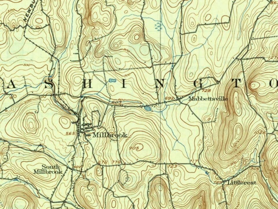
Founding dates: Wikidata, Wikipedia, the U.S. post office records of Blevins & Helbock (CC0) and the Census. Homes by year built: Census ACS 2020–24. National Register of Historic Places: National Park Service (list of May 22, 2026). Old photos, postcards and papers: Wikimedia Commons, the Library of Congress and other public archives, credited on each item’s page. Maps: U.S. Geological Survey historical topographic maps (via Esri) and Sanborn fire-insurance maps (Library of Congress). History text and census tables: Wikipedia (CC BY-SA 4.0). Places that used to be: USGS Geographic Names Information System (2021).
From Wikimedia Commons (4), the National Register of Historic Places (4), Wikipedia, U.S. Geological Survey historical maps, U.S. Census counts (via Wikipedia), the US Post Offices dataset (Blevins & Helbock), the USGS Geographic Names Information System and old county and town histories (Internet Archive). Archive images are copied here with their credits and licenses, shown on each photo’s page. Refreshed monthly.




 2022
 2020
 2008
 2008


