The Truxton post office opened in 1810, the earliest record of the town by name. Another post office, Cheningo (1839), opened inside today’s town and later closed.
First census: 2,956 in 18202020 census: 997216 years
Founding year: the first Truxton post office (Blevins & Helbock, CC0).The full story ↓
What stands out about Truxton’s past
Read from the archive, the National Register and the record. The page puts what stands out first.
The region that includes Cortland County was part of the Central New York Military Tract.
The first settler arrived around 1793. The town of Truxton was formed from part of the town of Fabius (in Onondaga County) when Cortland County was created in 1808. An addition was made in 1811 to Truxton from the town of Solon. In 1858, the eastern part of Truxton was used to form the town of Cuyler.
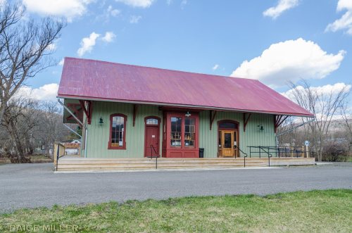
The Truxton Depot was listed on the National Register of Historic Places in 2008.
Truxton. — The town of Truxton was organized from the south half of the military town of Fabius, April 8, 1808. It also embraces four tiers of lots taken from the north part of Solon.
Text read by machine from the scan; it may contain errors.
The surface of the town of Truxton presents a broken and diversified aspect. The Truxton Flats are, however, very beautiful, rich, and abundant in agricultural elements ; yet they are unquestionably better adapted to the growing of the coarser grains, though wheat is produced to a limited extent.
Text read by machine from the scan; it may contain errors.
The streams of Truxton afford many excellent millseats, which in most instances are used to good advantage, placing her in the front rank of manufacturing towns in the county. There are five grist-mills, several saw-mills, a large sash and blind factory, a firkin and tub factory, and a Wool Exchange. The latter we propose to briefly notice. In 1809 Jonah Stiles and Alvin Pease erected a grist-mill, the second one in the town.
Text read by machine from the scan; it may contain errors.
Scans and text from the Internet Archive. Books published in 1930 or earlier, which are in the public domain.
Timeline
Truxton, 1810 to 1904
Woven from the archive, old maps, post office records, the National Register and the people born here.
Founding dates: Wikidata, Wikipedia, the U.S. post office records of Blevins & Helbock (CC0) and the Census. Homes by year built: Census ACS 2020–24. National Register of Historic Places: National Park Service (list of May 22, 2026). Old photos, postcards and papers: Wikimedia Commons, the Library of Congress and other public archives, credited on each item’s page. Maps: U.S. Geological Survey historical topographic maps (via Esri) and Sanborn fire-insurance maps (Library of Congress). History text and census tables: Wikipedia (CC BY-SA 4.0). Places that used to be: USGS Geographic Names Information System (2021). How TownRatings grades history →
From Wikimedia Commons (12), the National Register of Historic Places (1), Wikipedia, Wikidata and Wikipedia for famous people, U.S. Geological Survey historical maps, U.S. Census counts (via Wikipedia), the US Post Offices dataset (Blevins & Helbock), the USGS Geographic Names Information System and old county and town histories (Internet Archive). Archive images are copied here with their credits and licenses, shown on each photo’s page. Refreshed monthly.




 2025
 2016
 2016
 2015
 2012
 2010
 2010
 2010
 2005
 2005
 2005
 2005