Plattekill’s post office opened in 1819, and 12% of its homes were built before 1940
More historic than 78% of U.S. towns · #445 of 758 in New York. What drives it
5 places in town are on the National Register, among them two historic districts with 34 buildings between them. Below: 3 old photos and papers, maps from 1903 on, and the census since 1820.
The Plattekill post office opened in 1819, the earliest record of the town by name. Four smaller post offices, New Hurley (1810), Clarks Corner (1826) and Ardonia (1882), opened inside today’s town and later closed.
First census: 2,139 in 18202020 census: 10,424207 years
How historic is Plattekill?
A−
More historic than 78% of U.S. towns, on its age, its old homes and the National Register.
Founding year: the first Plattekill post office (Blevins & Helbock, CC0).The full story ↓
History grade
What drives Plattekill’s History grade
On its age, its old homes and the National Register, Plattekill is more historic than 78% of U.S. towns, #445 of 758 in New York. All 3 inputs are above most U.S. towns; its age ranks highest and its share of homes from before 1940 lowest.
A−
HistoryA character grade: shown, never part of Plattekill’s overall grade.
New York towns list more on the Register than most of the country (a typical New York town has 12.3 per 10,000 residents, the U.S. 2.4), so Plattekill’s 36.5 sits near the middle of its state (64% of New York towns have fewer) while its 38 historic buildings outnumber those of 83% of U.S. towns.
How sure. Graded on any two of the three inputs instead, the letter would range from B+ to A−. The pre-1940 share is a Census survey estimate (±4.5 points). The founding year is the first post office, not a stated founding date.
Founding year: the first post office (other dates in Quick answers). Homes: Census ACS 2020–24. National Register: National Park Service, May 2026 list; each listing counted once (boundary changes and added documentation belong to their listing), and a historic district counts its contributing buildings. How TownRatings grades history →
What stands out about Plattekill’s past
Read from the archive, the National Register and the record. The page puts what stands out first.
Lost post offices, old corners, places now gone and burying grounds
Plattekill’s post office has been open since 1819. Four other post offices opened and closed inside today’s town.
New Hurley
1810–1905
Plattekill
1819–today
Clarks Corner
1826–1829
Modena
1829–today
Clintondale
1849–today
Ardonia
1882–1974
Sylva
1886–1905
18101920today
Hamlets and corners on the map
Aloha Home Acres Mobile Home ParkArdoniaChurch Street Mobile Home ParkClintondaleDepew Mobile Home ParkFlintFox Run Estates Mobile Home ParkHideaway Mobile Home ParkModenaModena Country Club Mobile Home ParkModena GardensNew HurleySylvaTrout Brook Mobile Home ParkTuckers Corner
The area was settled by European settlers early in the 18th century, and the town was established in 1800 from part of the town of Marlborough.
The Reformed Dutch Church of New Hurley was built in the 1830s, and listed on the National Register of Historic Places in 1982. The Shuart-Van Orden Stone House was built in 1740 and listed on the National Register of Historic Places in 1995.
Passages that mention Plattekill, cut from the printed page as they were published.
The history of Ulster County, New York1907 · page 479Read the page →
Read the text
In the year 1807, Samuel Adams, Zephaniah Birdsall, James Pine, Merritt Moore and Tristrain Russel were appointed a committee by the Marlborough monthly meeting to establish a meeting at Clintondale in the town of Plattekill, and on August 20, 1811, John Underhill conveyed to Daniel Birdsall and Zephaniah Birdsall, trustees, in consideration of $34.41, one acre and thirty-nine perches of land in Plattekill (now in the village of Clintondale), upon which a meeting house was erected and used until 1889, when the present substantial meeting house was erected.
Text read by machine from the scan; it may contain errors.
History of the town of Marlborough, Ulster County, New York, from its earliest discovery1908 · page 25Read the page →
Read the text
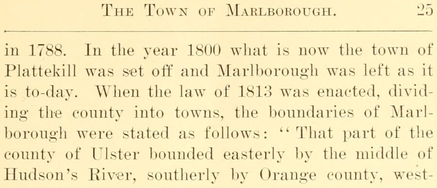
The Town of Marlborough. 25 in 1788. In the year 1800 what is now the town of Plattekill was set off and Marlborough was left as it is to-day. When the law of 1813 was enacted, dividing the county into towns, the boundaries of Marlborough were stated as follows: '' That part of the county of Ulster bounded easterly l)y the middle of Hudson's River, southerly by Orange county, west-
Text read by machine from the scan; it may contain errors.
History of Ulster County, New York, with illustrations and biographical sketches of its prominent men and pioneers1880Read the page →
Read the text
Tills is an interior town, lying south of the centre of the county. It is very irregular in outline. On the north lie the towns of Rochester and New Paltz, on the east the town of Plattekill, on the south the town of Shawangunk, ami on the west the towns of Wav, arsing and Rochester. The farm acreage of the towu is 2-1,301, and the population, as given by the census of 1875, 1700.
Text read by machine from the scan; it may contain errors.
The history of Ulster County, New York1907 · page 339Read the page →
Read the text
Larkin and J. C. Washburn. In 1850 the Circuit was divided ; three more appointments had been added during the pastorate of Thomas Newman, viz. : Tuthill, Clintondale and Old Paltz. By this division the Plattekill Church, East Plattekill and Clintondale were set off by themselves and established into a charge called Plattekill. In 1854 J. C. Brodhead donated a lot for a new church at Modena Corners. The new church was built in 1855 a cost of $4,528.18, and dedicated by Rev. L. W. Vincent, Presiding Elder of the Newburgh Dis-
Text read by machine from the scan; it may contain errors.
Scans and text from the Internet Archive. Books published in 1930 or earlier, which are in the public domain.
Timeline
Plattekill, 1800 to 1905
Woven from the archive, old maps, post office records, the National Register and the people born here.
Nothing in the archives for these yearsWeddings on Main Street, storms, parades, school pictures, the old store. If it’s in your family album, it belongs here.
The Plattekill post office opened in 1819, the earliest record of the town by name (U.S. post office records).
How does Plattekill rank for history?
Plattekill is more historic than 78% of U.S. towns, #445 of 758 in New York. The History grade combines the town’s founding era, the share of homes built before 1940 and its National Register listings. It’s a character grade, so it isn’t part of the overall grade. How it works.
What is on the National Register in Plattekill?
5 listings: 3 buildings, among them the Reformed Dutch Church of New Hurley (listed 1982, the first), and 2 historic districts, the Thaddeus Hait Farm and the Cole-Hasbrouck Farm Historic District, with 34 contributing buildings. 38 historic buildings in all.
How old are the homes in Plattekill?
12% of Plattekill’s homes were built before 1940 (Census estimate, ±4.5 points), against a typical 27% for a New York town; the median home was built in 1979.
Founding dates: Wikidata, Wikipedia, the U.S. post office records of Blevins & Helbock (CC0) and the Census. Homes by year built: Census ACS 2020–24. National Register of Historic Places: National Park Service (list of May 22, 2026). Old photos, postcards and papers: Wikimedia Commons, the Library of Congress and other public archives, credited on each item’s page. Maps: U.S. Geological Survey historical topographic maps (via Esri) and Sanborn fire-insurance maps (Library of Congress). History text and census tables: Wikipedia (CC BY-SA 4.0). Places that used to be: USGS Geographic Names Information System (2021).
From Wikimedia Commons (11), the National Register of Historic Places (5), Wikipedia, U.S. Geological Survey historical maps, U.S. Census counts (via Wikipedia), the US Post Offices dataset (Blevins & Helbock), the USGS Geographic Names Information System and old county and town histories (Internet Archive). Archive images are copied here with their credits and licenses, shown on each photo’s page. Refreshed monthly.




 1875
 2023
 2022
 2011
 2007
 2007
 2007
 2007
 2007


