Founding year: Wikidata. First post office: 1850.The full story ↓
History grade
What drives Oswego’s History grade
On its age, its old homes and the National Register, Oswego is more historic than 68% of U.S. towns, #539 of 758 in New York. Its age holds the grade up; its National Register listings pull it down.
B+
HistoryA character grade: shown, never part of Oswego’s overall grade.
New York towns list more on the Register than most of the country (a typical New York town has 12.3 per 10,000 residents, the U.S. 2.4), so Oswego’s 2.4 sits below most of its state (26% of New York towns have fewer) while its 2 historic buildings outnumber those of 60% of U.S. towns.
NoteThe founding year comes from Wikidata alone; no second source gives 1796.
How sure. Graded on any two of the three inputs instead, the letter would range from B to A−. The pre-1940 share is a Census survey estimate (±6.0 points).
Founding year: Wikidata (other dates in Quick answers). Homes: Census ACS 2020–24. National Register: National Park Service, May 2026 list; each listing counted once (boundary changes and added documentation belong to their listing), and a historic district counts its contributing buildings. How TownRatings grades history →
What stands out about Oswego’s past
Read from the archive, the National Register and the record. The page puts what stands out first.
Lost post offices, old corners, places now gone and burying grounds
Three other post offices opened and closed inside today’s town.
South West Oswego
1850–1905
Oswego Centre
1867–1913
Fruit Valley
1879–1905
18501940today
Hamlets and corners on the map
Fruit ValleyFurnissOrchard Mobile Home ParkOswego BeachOswego CenterSouthwest OswegoThompson Mobile Home ParkWaterview Mobile Home Park
Gone or out of use
School Number 1schoolSchool Number 10schoolSchool Number 11schoolSchool Number 12schoolSchool Number 13schoolSchool Number 14schoolSchool Number 2schoolSchool Number 4schoolSchool Number 5schoolSchool Number 6schoolSchool Number 7schoolSchool Number 8schoolSchool Number 9school
4cemeteries and burying grounds inside Oswego
Old IrishRiceStevensTown of Oswego Rural
US Post Offices dataset (Blevins & Helbock, CC0). Places and cemeteries from the USGS Geographic Names Information System (2021).
On the map
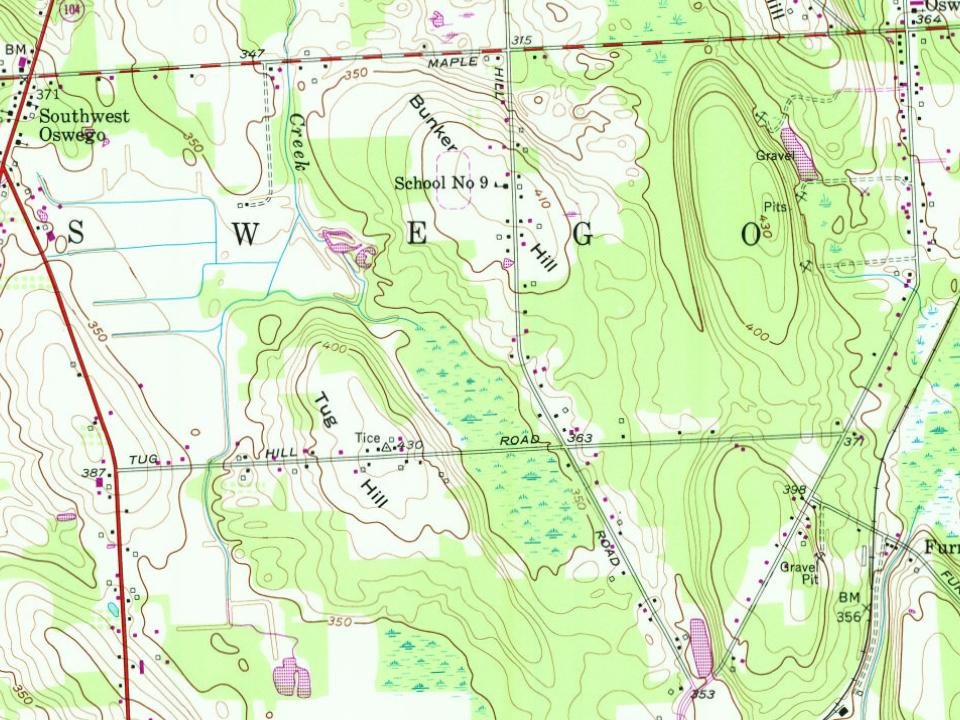
Oswego on the map, 1900 to 1978
Every edition of the U.S. Geological Survey’s map of Oswego. Tap a year, or press play to watch the town change.
1900Oswego sheet · 1:62,500
U.S. Geological Survey historical topographic maps (public domain), via Esri’s collection of the scans. The red ring marks the center of Oswego.
People over time
Oswego, census by census
Peaked at 23,626 in 1920; 16,921 people lived here in 2020.
18 censuses, 1850–2020.
U.S. Census Bureau decennial counts, from the census table on Oswego’s Wikipedia page.
The British established a trading post in the area in 1722 and fortified it with a log palisade later called Fort Oswego, named after the native Iroquois place name "os-we-go" meaning "pouring out place" (Onondaga: Deyoʼswé·geʼ ). The first fortification on the site of the current Fort Ontario was built by the British in 1755 and called the "Fort of the Six Nations".
Passages that mention Oswego, cut from the printed page as they were published.
Onondaga, or, Reminiscences of earlier and later times [microform] being a series of historical sketches relative to Onondaga1849 · page 180Read the page →
Read the text
Oswego, which were again garrisoned. It was at this period that the design was formed by General Abercrombie, of erecting a substantial fort, to command the entrance to Lake Oneida from the west, as it was already commanded on the east, by Fort Stanwix. A detachment was sent from Oswego, the following year, to co-operate with one from Fort Stanwix, and an earthen fort completed on the plan as it now appears, and named Fort Brewerton, in honor of Captain Brewerton,
Text read by machine from the scan; it may contain errors.
Onondaga, or, Reminiscences of earlier and later times [microform] being a series of historical sketches relative to Onondaga1849 · page 363Read the page →
Read the text
not a heavy rain interposed and disabled Col. Bradstreet from following up his success, for that same night he was joined by Captain Patten with a company of grenadiers, on his march from Oneida to Oswego, and next morning he was re-enforced by the arrival of two hundred men, detached to his assistance from the garrison at Oswego. On the 29th of May the French landed on the south-eastern side of Lake Ontario, about fifty miles 'from Oswego, were joined by about three hundred Indi-
Text read by machine from the scan; it may contain errors.
Scans and text from the Internet Archive. Books published in 1930 or earlier, which are in the public domain.
Timeline
Oswego, 1796 to 1960
Woven from the archive, old maps, post office records, the National Register and the people born here.
Nothing in the archives for these yearsWeddings on Main Street, storms, parades, school pictures, the old store. If it’s in your family album, it belongs here.
Fire insurance maps drew every building, what it was made of and what it was used for, so insurers could price the risk of fire. Pick a year, then a sheet.
In 1796, according to Wikidata. Oswego’s post office opened in 1850, and the census of 1850 counted 12,205 people here.
How does Oswego rank for history?
Oswego is more historic than 68% of U.S. towns, #539 of 758 in New York. The History grade combines the town’s founding era, the share of homes built before 1940 and its National Register listings. It’s a character grade, so it isn’t part of the overall grade. How it works.
What is on the National Register in Oswego?
One place: the Daniel and Miriam Pease House (listed 2002).
How old are the homes in Oswego?
17% of Oswego’s homes were built before 1940 (Census estimate, ±6.0 points), against a typical 27% for a New York town; the median home was built in 1977.
Founding dates: Wikidata, Wikipedia, the U.S. post office records of Blevins & Helbock (CC0) and the Census. Homes by year built: Census ACS 2020–24. National Register of Historic Places: National Park Service (list of May 22, 2026). Old photos, postcards and papers: Wikimedia Commons, the Library of Congress and other public archives, credited on each item’s page. Maps: U.S. Geological Survey historical topographic maps (via Esri) and Sanborn fire-insurance maps (Library of Congress). History text and census tables: Wikipedia (CC BY-SA 4.0). Places that used to be: USGS Geographic Names Information System (2021).
From Wikimedia Commons (10), Wikidata (1), the National Register of Historic Places (1), Wikipedia, Wikidata and Wikipedia for famous people, U.S. Geological Survey historical maps, U.S. Census counts (via Wikipedia), the US Post Offices dataset (Blevins & Helbock), the USGS Geographic Names Information System, Sanborn fire insurance maps (Library of Congress) and old county and town histories (Internet Archive). Archive images are copied here with their credits and licenses, shown on each photo’s page. Refreshed monthly.




 1864
 1876
 1898
 1909


