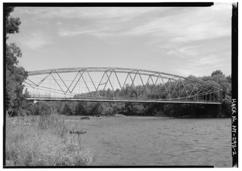
Norfolk dates to 1809, and 18% of its homes were built before 1940
More historic than 66% of U.S. towns · #553 of 758 in New York. What drives it
Its Register listings are the Raymondville Parabolic Bridge, the Hepburn Library and the Hale Cemetery. Below: maps from 1906 on and the census since 1830.
Founding year: Wikidata. First post office: 1823.The full story ↓
History grade
What drives Norfolk’s History grade
On its age, its old homes and the National Register, Norfolk is more historic than 66% of U.S. towns, #553 of 758 in New York. All 2 inputs are above most U.S. towns; its share of homes from before 1940 ranks highest and its National Register listings lowest.
B+
HistoryA character grade: shown, never part of Norfolk’s overall grade.
New York towns list more on the Register than most of the country (a typical New York town has 12.3 per 10,000 residents, the U.S. 2.4), so Norfolk’s 6.8 sits near the middle of its state (40% of New York towns have fewer) while its 3 listings outnumber those of 65% of U.S. towns.
How sure. Graded on two of the three inputs, so a change in either one moves the letter more than it would with three. The pre-1940 share is a Census survey estimate (±5.9 points). Two sources give 1809.
Founding year: Wikidata (other dates in Quick answers). Homes: Census ACS 2020–24. National Register: National Park Service, May 2026 list; each listing counted once (boundary changes and added documentation belong to their listing), and a historic district counts its contributing buildings. How TownRatings grades history →
What stands out about Norfolk’s past
Read from the archive, the National Register and the record. The page puts what stands out first.
Lost post offices, old corners, places now gone and burying grounds
Norfolk’s post office has been open since 1823. Two other post offices opened and closed inside today’s town.
Norfolk
1823–today
Graysville
1831–1836
Raymondville
1840–today
Plum Brook
1876–1932
18201920today
Hamlets and corners on the map
GrantvilleNorfolk Mobile Home ParkPine Grove Mobile Home ParkPlumbrookRaymondvilleYaleville
Gone or out of use
School Number 10schoolSchool Number 11schoolSchool Number 12schoolSchool Number 2schoolSchool Number 3schoolSchool Number 5schoolSchool Number 6schoolSchool Number 9school
4cemeteries and burying grounds inside Norfolk
Kent MillKylePine GroveVisitation
US Post Offices dataset (Blevins & Helbock, CC0). Places and cemeteries from the USGS Geographic Names Information System (2021).
On the map
Norfolk on the map, 1906 to 1964
Every edition of the U.S. Geological Survey’s map of Norfolk. Tap a year, or press play to watch the town change.
1906Massena sheet · 1:62,500
U.S. Geological Survey historical topographic maps (public domain), via Esri’s collection of the scans. The red ring marks the center of Norfolk.
The town was formed in 1869 from part of the Town of Louisville. In 1869, part of Norfolk was returned to Louisville, and part of the Town of Stockholm was added to Norfolk in 1869.
A small part of Norfolk was lost when the community of "Raquetteville" incorporated as the Village of Potsdam Junction in 1869. In 1875, it became Norwood.
The Hepburn Library was listed on the National Register of Historic Places in 1969.
Passages that mention Norfolk, cut from the printed page as they were published.
History of Norfolk County, Massachusetts, 1622-19181918 · page 223Read the page →
Read the text
POSTOFFICES About 1819, sixty-one years before the Town of Norfolk was incorporated, Eli Richardson built the stone store building at City Mills and secured an appointment as postmaster of the office established soon after the building was completed. This was the first postoffice within the present limits of the Town of Norfolk. Some years later an office was established at the "Centre" and was given the name of Norfolk. Deanville, in the northwestern part, and Pondville, in the southeastern part, were once postoffices, but they have been discontinued.
Text read by machine from the scan; it may contain errors.
History of Norfolk County, Massachusetts, 1622-19181918 · page 220Read the page →
Read the text
EARLY HISTORY The general history of Norfolk is uneventful. When the Town of Wrentham was incorporated in October, 1673, it included the greater part of the present Town of Norfolk, and the territory remained attached to Wrentham for nearly two centuries. The first settlements were made here while the town was still a part of Wrentham and the early history is therefore incorporated in the chapter relating to that town. Among the early settlers in this section were the Blakes, Days, Holbrooks, Manns, Ponds, Richardsons, Wares and several other families
Text read by machine from the scan; it may contain errors.
Scans and text from the Internet Archive. Books published in 1930 or earlier, which are in the public domain.
Timeline
Norfolk, 1809 to 1913
Woven from the archive, old maps, post office records, the National Register and the people born here.
In 1809, according to Wikidata. Norfolk’s post office opened in 1823, and the census of 1830 counted 1,309 people here.
How does Norfolk rank for history?
Norfolk is more historic than 66% of U.S. towns, #553 of 758 in New York. The History grade combines the town’s founding era, the share of homes built before 1940 and its National Register listings. It’s a character grade, so it isn’t part of the overall grade. How it works.
What is on the National Register in Norfolk?
Three places: the Raymondville Parabolic Bridge (listed 1984), the Hepburn Library (2004) and the Hale Cemetery (2024).
How old are the homes in Norfolk?
18% of Norfolk’s homes were built before 1940 (Census estimate, ±5.9 points), against a typical 27% for a New York town; the median home was built in 1973.
Founding dates: Wikidata, Wikipedia, the U.S. post office records of Blevins & Helbock (CC0) and the Census. Homes by year built: Census ACS 2020–24. National Register of Historic Places: National Park Service (list of May 22, 2026). Old photos, postcards and papers: Wikimedia Commons, the Library of Congress and other public archives, credited on each item’s page. Maps: U.S. Geological Survey historical topographic maps (via Esri) and Sanborn fire-insurance maps (Library of Congress). History text and census tables: Wikipedia (CC BY-SA 4.0). Places that used to be: USGS Geographic Names Information System (2021).
From Wikimedia Commons (3), the National Register of Historic Places (3), Wikipedia, Wikidata and Wikipedia for famous people, U.S. Geological Survey historical maps, U.S. Census counts (via Wikipedia), the US Post Offices dataset (Blevins & Helbock), the USGS Geographic Names Information System, Sanborn fire insurance maps (Library of Congress) and old county and town histories (Internet Archive). Archive images are copied here with their credits and licenses, shown on each photo’s page. Refreshed monthly.


 2025
 2020
 2011