Irondequoit’s post office opened in 1839, and 24% of its homes were built before 1940
More historic than 86% of U.S. towns · #336 of 758 in New York. What drives it
4 places in town are on the National Register, among them two historic districts with 56 buildings between them. Below: 1 old photo or paper, maps from 1895 on, and the census since 1840.
From Irondequoit’s archive · credits on each photo
Quick answers
How Irondequoit began
When was Irondequoit founded?
1839
The Irondequoit post office opened in 1839, the earliest record of the town by name. Three smaller post offices, East Riga (1819), Sea Breeze (1910) and Point Pleasant (1922), opened inside today’s town and later closed.
First census: 1,252 in 18402020 census: 51,043187 years
How historic is Irondequoit?
A
More historic than 86% of U.S. towns, on its age, its old homes and the National Register.
Founding year: the first Irondequoit post office (Blevins & Helbock, CC0).The full story ↓
History grade
What drives Irondequoit’s History grade
On its age, its old homes and the National Register, Irondequoit is more historic than 86% of U.S. towns, #336 of 758 in New York. All 3 inputs are above most U.S. towns; its share of homes from before 1940 ranks highest and its National Register listings lowest.
A
HistoryA character grade: shown, never part of Irondequoit’s overall grade.
New York towns list more on the Register than most of the country (a typical New York town has 12.3 per 10,000 residents, the U.S. 2.4), so Irondequoit’s 11.6 sits near the middle of its state (48% of New York towns have fewer) while its 59 historic buildings outnumber those of 86% of U.S. towns.
How sure. Graded on any two of the three inputs instead, the letter would still be A−. The pre-1940 share (±2.3 points) is firm at this size. The founding year is the first post office, not a stated founding date.
Founding year: the first post office (other dates in Quick answers). Homes: Census ACS 2020–24. National Register: National Park Service, May 2026 list; each listing counted once (boundary changes and added documentation belong to their listing), and a historic district counts its contributing buildings. How TownRatings grades history →
What stands out about Irondequoit’s past
Read from the archive, the National Register and the record. The page puts what stands out first.
In 1687 the Marquis de Denonville led an army of French soldiers and Wyandot warriors on a punitive expedition against the Haudenosaunee through Irondequoit Bay, beginning the long enmity between the Haudenosaunee and the French.
After the American Revolution, this area was part of the Phelps and Gorham Purchase. The Town of Irondequoit was founded in 1839 when it separated from the town of Brighton.
During the last part of the 19th century, the north edge of the town was developed as a tourist and vacation area for Rochester residents, and was once known as the "Coney Island of Western New York".
Passages that mention Irondequoit, cut from the printed page as they were published.
History of Rochester and Monroe county, New York1908 · page 1221Read the page →
Read the text
until about 1841, when, seeing opportunity for broadening the scope of his business, he disposed of Ins stock of groceries and purchased a farm in Irondequoit, upon, which he built a large sawmill. There he engaged in the manufacture of hmiber for a number' of years, finding a ready market for his product in Rochester's building operations. Constantly watchful of opportuni-
Text read by machine from the scan; it may contain errors.
History of the pioneer settlement of Phelps and Gorham's purchase, and Morris' reserve1851 · page 422Read the page →
Read the text
of Berkshire, as fifteen hundred acres of the township near the head of Irondequoit Bay, was set off to him, while the survey of the township into farm lots was progressing. Mr. Lusk was the pioneer in improvement and settlement, and in fact bore that relation to all of what is now Monroe county, having even preceded the Shaeffers several months. With his son Stephen, then fifteen years old, and Seely Peet, a hired man, he came to the new region early in the summer of 1789. Arriving at Schenectady, he embarked
Text read by machine from the scan; it may contain errors.
History of the pioneer settlement of Phelps and Gorham's purchase, and Morris' reserve1851 · page 523Read the page →
Read the text
Mr. Penfield erected a grist and saw mill, at the Falls of the Irondequoit, in 1805. As has been observed, he did not become a resident until 1811. In 1813, Henry Ward (who has been named in connection with reminiscences of Tryon Town,) became his clerk, continuing as such until 1821. Mr. Penfield erected a flouring mill at an expense of $15,000. It is now owned by J. B. Roe. In 1836, James K. Livingston erected a stone flouring mill, at an expense of $30,000, which is now owned by Samuel Miller.
Text read by machine from the scan; it may contain errors.
Scans and text from the Internet Archive. Books published in 1930 or earlier, which are in the public domain.
Timeline
Irondequoit, 1819 to 1979
Woven from the archive, old maps, post office records, the National Register and the people born here.
Nothing in the archives for these yearsWeddings on Main Street, storms, parades, school pictures, the old store. If it’s in your family album, it belongs here.
The Irondequoit post office opened in 1839, the earliest record of the town by name (U.S. post office records).
How does Irondequoit rank for history?
Irondequoit is more historic than 86% of U.S. towns, #336 of 758 in New York. The History grade combines the town’s founding era, the share of homes built before 1940 and its National Register listings. It’s a character grade, so it isn’t part of the overall grade. How it works.
What is on the National Register in Irondequoit?
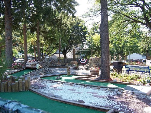
4 listings: 2 buildings, among them the United Congregational Church of Irondequoit (listed 2002, the first), and 2 historic districts, the Tall Maples Miniature Golf Course and the Wimbledon Road Historic District, with 56 contributing buildings. 59 historic buildings in all.
How old are the homes in Irondequoit?
24% of Irondequoit’s homes were built before 1940 (Census estimate, ±2.3 points), against a typical 27% for a New York town; the median home was built in 1955.
Founding dates: Wikidata, Wikipedia, the U.S. post office records of Blevins & Helbock (CC0) and the Census. Homes by year built: Census ACS 2020–24. National Register of Historic Places: National Park Service (list of May 22, 2026). Old photos, postcards and papers: Wikimedia Commons, the Library of Congress and other public archives, credited on each item’s page. Maps: U.S. Geological Survey historical topographic maps (via Esri) and Sanborn fire-insurance maps (Library of Congress). History text and census tables: Wikipedia (CC BY-SA 4.0). Places that used to be: USGS Geographic Names Information System (2021).
From Wikimedia Commons (5), Wikidata (1), the National Register of Historic Places (4), Wikipedia, U.S. Geological Survey historical maps, U.S. Census counts (via Wikipedia), the US Post Offices dataset (Blevins & Helbock), the USGS Geographic Names Information System and old county and town histories (Internet Archive). Archive images are copied here with their credits and licenses, shown on each photo’s page. Refreshed monthly.



 2004
 2004
 2004
 2004


