Hastings’ post office opened in 1828, and 11% of its homes were built before 1940
More historic than 60% of U.S. towns · #598 of 758 in New York. What drives it
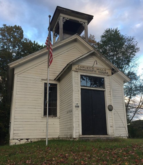
Its Register listings are the Carley's Mills Schoolhouse and the Fort Brewerton. Below: 12 old photos and papers, maps from 1905 on, and the census since 1820.
The Hastings post office opened in 1828, the earliest record of the town by name. Four smaller post offices, Caughdenoy (1850), Hastings Centre (1851) and Little France (1876), opened inside today’s town and later closed.
First census: 741 in 18202020 census: 9,342198 years
How historic is Hastings?
B
More historic than 60% of U.S. towns, on its age, its old homes and the National Register.
Founding year: the first Hastings post office (Blevins & Helbock, CC0).The full story ↓
History grade
What drives Hastings’ History grade
On its age, its old homes and the National Register, Hastings is more historic than 60% of U.S. towns, #598 of 758 in New York. Its age holds the grade up; its National Register listings pull it down.
B
HistoryA character grade: shown, never part of Hastings’ overall grade.
New York towns list more on the Register than most of the country (a typical New York town has 12.3 per 10,000 residents, the U.S. 2.4), so Hastings’ 2.1 sits below most of its state (26% of New York towns have fewer) while its 2 listings outnumber those of 60% of U.S. towns.
How sure. Graded on any two of the three inputs instead, the letter would range from C+ to B+. The pre-1940 share is a Census survey estimate (±4.1 points). The founding year is the first post office, not a stated founding date.
Founding year: the first post office (other dates in Quick answers). Homes: Census ACS 2020–24. National Register: National Park Service, May 2026 list; each listing counted once (boundary changes and added documentation belong to their listing), and a historic district counts its contributing buildings. How TownRatings grades history →
What stands out about Hastings’ past
Read from the archive, the National Register and the record. The page puts what stands out first.
Lost post offices, old corners, places now gone and burying grounds
Hastings’s post office has been open since 1828. Four other post offices opened and closed inside today’s town.
Central Square
1822–today
Hastings
1828–today
Caughdenoy
1850–1919
Hastings Centre
1851–1908
Mallory
1862–today
Little France
1876–1904
Morse
1891–1894
18201920today
Hamlets and corners on the map
Bardeen CornersBlue Spruce Mobile Home ParkCarley MillsCaughdenoyCentral SquareHastings CenterLittle FranceLyndon Lawns Mobile Home ParkMalloryMorseRoxbury Estates Mobile Home ParkSummerhill Village Mobile Home Park
Gone or out of use
Caughdenoy AirportairportSchool Number 1schoolSchool Number 10schoolSchool Number 11schoolSchool Number 12schoolSchool Number 13schoolSchool Number 16schoolSchool Number 2schoolSchool Number 5schoolSchool Number 6schoolSchool Number 7schoolSchool Number 8schoolSchool Number 9schoolSyracuse Suburban Airportairport
8cemeteries and burying grounds inside Hastings
AllenCarley MillsCaughdenoyCoitHastingsHillsidePine GroveSaint Francis
US Post Offices dataset (Blevins & Helbock, CC0). Places and cemeteries from the USGS Geographic Names Information System (2021).
People over time
Hastings, census by census
Lost a third of its people between 1860 and 1930, then grew 4-fold.
20 censuses, 1820–2010.
U.S. Census Bureau decennial counts, from the census table on Hastings’ Wikipedia page.
By decade
Hastings, decade by decade
3 decades in the archive, from the 1860s to the 1910s. Scroll each row; tap a photo for its story.
Nothing in the archives for these yearsWeddings on Main Street, storms, parades, school pictures, the old store. If it’s in your family album, it belongs here.
Hastings was the first town settled in Oswego County when Oliver Stevens built a rude house near the abandoned Fort Brewerton in 1789. Stevens used the location to trade with Indians and to provide a tavern-like establishment for the boatmen who frequented the nearby river and lake. The region was originally called "Breda." The town was formed in 1825 from Constantia. The early industry was lumbering and manufacturing of wooden products.
The Carley's Mills Schoolhouse was listed on the National Register of Historic Places in 2005.
The Hastings post office opened in 1828, the earliest record of the town by name (U.S. post office records).
How does Hastings rank for history?
Hastings is more historic than 60% of U.S. towns, #598 of 758 in New York. The History grade combines the town’s founding era, the share of homes built before 1940 and its National Register listings. It’s a character grade, so it isn’t part of the overall grade. How it works.
What is on the National Register in Hastings?
Two places: the Carley's Mills Schoolhouse (listed 2005) and the Fort Brewerton (1973).
How old are the homes in Hastings?
11% of Hastings’ homes were built before 1940 (Census estimate, ±4.1 points), against a typical 27% for a New York town; the median home was built in 1984.
Founding dates: Wikidata, Wikipedia, the U.S. post office records of Blevins & Helbock (CC0) and the Census. Homes by year built: Census ACS 2020–24. National Register of Historic Places: National Park Service (list of May 22, 2026). Old photos, postcards and papers: Wikimedia Commons, the Library of Congress and other public archives, credited on each item’s page. Maps: U.S. Geological Survey historical topographic maps (via Esri) and Sanborn fire-insurance maps (Library of Congress). History text and census tables: Wikipedia (CC BY-SA 4.0). Places that used to be: USGS Geographic Names Information System (2021).
From Wikimedia Commons (12), the National Register of Historic Places (2), Wikipedia, Wikidata and Wikipedia for famous people, U.S. Geological Survey historical maps, U.S. Census counts (via Wikipedia), the US Post Offices dataset (Blevins & Helbock) and the USGS Geographic Names Information System. Archive images are copied here with their credits and licenses, shown on each photo’s page. Refreshed monthly.


 1860
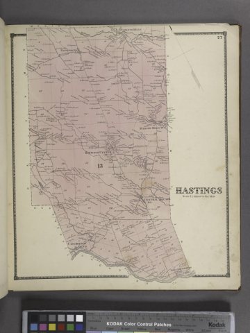 1867
 1867
 1872
 1910
 1917
 1917
 1917
 1917
 1917
 1917
 1917