Every edition of the U.S. Geological Survey’s map of Cold Spring Harbor. Tap a year, or press play to watch the town change.
1901Northport sheet · 1:62,500
U.S. Geological Survey historical topographic maps (public domain), via Esri’s collection of the scans. The red ring marks the center of Cold Spring Harbor.
By decade
Cold Spring Harbor, decade by decade
4 decades in the archive, from the 1870s to the 1910s. Scroll each row; tap a photo for its story.
Nothing in the archives for these yearsWeddings on Main Street, storms, parades, school pictures, the old store. If it’s in your family album, it belongs here.
Cold Spring Harbor was named after the naturally cold freshwater springs that flow in the area. Its economy mainly tied to milling and port activities, it rose in prominence as a whaling community in the mid-nineteenth century. After the decline of whaling in the 1860s, it became a resort town with several hotels. In the 20th century it became known as the site of Cold Spring Harbor Laboratory, although the laboratory itself is located in the adjacent village of Laurel Hollow in Nassau County, which was called Cold Spring before incorporation.
Passages that mention Cold Spring Harbor, cut from the printed page as they were published.
...History of Suffolk county, New York1882 · page 55Read the page →
Read the text
After the above date church matters were in abeyance until August 6th 1834, when the Rev. Isaac Sherwood took charge of the mission and ofificiated alternately in this church and the school-house at Cold Spring Harbor. After his ordination to the priesthood, which occurred on the 29th of April 1835, the mission at Oyster Bay was under his care for a lime also. The corner stone of St. John's church at Cold Spring Harbor was laid, by
Text read by machine from the scan; it may contain errors.
Scans and text from the Internet Archive. Books published in 1930 or earlier, which are in the public domain.
Timeline
Cold Spring Harbor, 1873 to 1997
Woven from the archive, old maps, post office records, the National Register and the people born here.
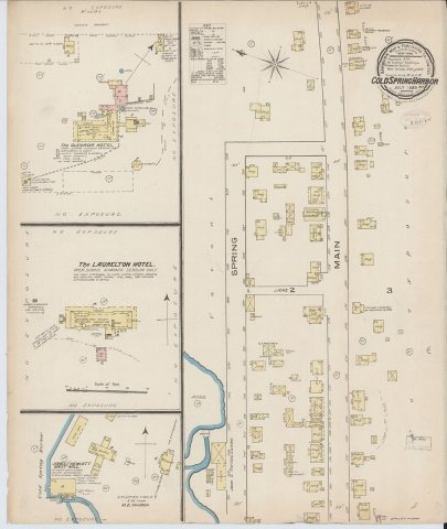
Cold Spring Harbor, building by building, 1885–1917
Fire insurance maps drew every building, what it was made of and what it was used for, so insurers could price the risk of fire. Pick a year, then a sheet.
1885Sheet 1 of 1
Edition
Sheets
BrickWoodStone
Sanborn Map Company, via the Library of Congress. Editions published in 1930 or earlier, which are in the public domain.
Then & now
Stand where they stood
No then-and-now pairs yet. Take a photo from the same spot as an old one and they appear here side by side.
Retake this viewPSM V66 D487 Cold spring harbor station for experimental evolution, 1904
Find the spot, match the angle, and add your photo. It becomes the first then-and-now pair on Cold Spring Harbor’s page.
Founding dates: Wikidata, Wikipedia, the U.S. post office records of Blevins & Helbock (CC0) and the Census. Homes by year built: Census ACS 2020–24. National Register of Historic Places: National Park Service (list of May 22, 2026). Old photos, postcards and papers: Wikimedia Commons, the Library of Congress and other public archives, credited on each item’s page. Maps: U.S. Geological Survey historical topographic maps (via Esri) and Sanborn fire-insurance maps (Library of Congress). History text and census tables: Wikipedia (CC BY-SA 4.0). Places that used to be: USGS Geographic Names Information System (2021). How TownRatings grades history →
From Wikimedia Commons (12), the Library of Congress (4), Wikipedia, Wikidata and Wikipedia for famous people, U.S. Geological Survey historical maps, U.S. Census counts (via Wikipedia), Sanborn fire insurance maps (Library of Congress) and old county and town histories (Internet Archive). Archive images are copied here with their credits and licenses, shown on each photo’s page. Refreshed monthly.


 1873
 1885
 1902
 1902
 1904
 1904
 1905
 1905
 1910
 1915
 1915
 1915
 1916
 1916
 1916
 1917


