Woodbridge Township dates to 1664, and 11% of its homes were built before 1940
More historic than 75% of U.S. towns · #151 of 468 in New Jersey. What drives it
Its Register listings are the Barron Library, the Trinity Episcopal Church and the First Presbyterian Church and Cemetery. Below: 13 old photos and papers, maps from 1888 on, and the census since 1790.
Founding year: Wikidata. First post office: 1776.The full story ↓
History grade
What drives Woodbridge Township’s History grade
On its age, its old homes and the National Register, Woodbridge Township is more historic than 75% of U.S. towns, #151 of 468 in New Jersey. Its age holds the grade up; its National Register listings pull it down.
B+
HistoryA character grade: shown, never part of Woodbridge Township’s overall grade.
Among the 400 U.S. cities of 100,000 or more, Woodbridge Township ranks #148 on History.
New Jersey towns list more on the Register than most of the country (a typical New Jersey town has 3.7 per 10,000 residents, the U.S. 2.4), so Woodbridge Township’s 0.5 sits below most of its state (26% of New Jersey towns have fewer) while its 5 historic buildings outnumber those of 70% of U.S. towns.
NoteThe founding year comes from Wikidata alone; no second source gives 1664.
How sure. Graded on any two of the three inputs instead, the letter would range from B− to A−. The pre-1940 share (±1.2 points) is firm at this size.
Founding year: Wikidata (other dates in Quick answers). Homes: Census ACS 2020–24. National Register: National Park Service, May 2026 list; each listing counted once (boundary changes and added documentation belong to their listing), and a historic district counts its contributing buildings. How TownRatings grades history →
What stands out about Woodbridge Township’s past
Read from the archive, the National Register and the record. The page puts what stands out first.
Lost post offices, old corners, places now gone and burying grounds
Two other post offices opened and closed inside today’s town.
Woodbridge
1776–today
Iselin
1875–today
Sewaren
1884–today
Fords
1890–1944
Port Reading
1893–today
Colonia
1894–1955
Avenel
1898–today
Keasbey
1898–today
17701900today
Hamlets and corners on the map
AvenelBoynton BeachColoniaEdgarFordsHazeltonHopelawnIselinKeasbeyLynn WoodoaksMenlo Park TerracePort ReadingSand HillsSewarenShore ViewWoodbridgeWoodbridge Oaks
Gone or out of use
Broad Meadow NurserieslocaleColonia Grade SchoolschoolGrade School Number 10schoolGrade School Number 11schoolGrade School Number 7schoolGrade School Number 8schoolMaple Hill DairylocaleRahway PlantairportSutton-Metro ParkairportWoodbridge Grade School Number 12schoolWoodbridge Grade School Number 15schoolWoodbridge Grade School Number 3schoolWoodbridge Public School Number 6schoolWoodbridge Speedwaylocale
17cemeteries and burying grounds inside Woodbridge Township
Beth Israel Cemetery - Woodbridge Memorial ParkCalvaryClover Leaf Memorial ParkHebrew FraternityMount Lebanon Cemetery - Forest Lawn Memorial GardensOur Lady of HungaryOur Lady of the Most Holy Rosary ParishSaint GertrudesSaint JamesSaint Michael's ParishSaint Spiridon Russian OrthodoxSaint StephensSaints Cyrillus and MethodiusTrinityUkrainian Catholic Church of the AssumptionWindsor GardensWoodbridge Memorial Gardens
US Post Offices dataset (Blevins & Helbock, CC0). Places and cemeteries from the USGS Geographic Names Information System (2021).
Timeline
Woodbridge Township, 1664 to 1988
Woven from the archive, old maps, post office records, the National Register and the people born here.
Every edition of the U.S. Geological Survey’s map of Woodbridge Township. Tap a year, or press play to watch the town change.
1888Plainfield sheet · 1:62,500
U.S. Geological Survey historical topographic maps (public domain), via Esri’s collection of the scans. The red ring marks the center of Woodbridge Township.
According to historian Joshua Coffin, the community's early settlers included: Captain John Pike, the ancestor of General Zebulon Montgomery Pike, who was killed at the battle of Queenstown in 1813; Thomas Bloomfield, the ancestor of Joseph Bloomfield, some years governor of New Jersey, for whom the township of Bloomfield is named; John Bishop, senior and junior; Jonathan Haynes; Henry Jaques; George March; Stephen Kent; Abraham Toppan, junior; Elisha Ilsley; Hugh March; John Bloomfield; Samuel Moore; Nathaniel Webster; John Ilsley; and others." Woodbridge was the site of the first gristmill in New Jersey. The mill was built by Jonathan Singletary Dunham, who was married to Mary Bloomfield, relative of Joseph Bloomfield.
Nothing in the archives for these yearsWeddings on Main Street, storms, parades, school pictures, the old store. If it’s in your family album, it belongs here.
Nothing in the archives for these yearsWeddings on Main Street, storms, parades, school pictures, the old store. If it’s in your family album, it belongs here.
In 1664, according to Wikidata. Woodbridge Township’s post office opened in 1776, and the first U.S. census counted 3,520 people here in 1790.
How does Woodbridge Township rank for history?
Woodbridge Township is more historic than 75% of U.S. towns, #151 of 468 in New Jersey. The History grade combines the town’s founding era, the share of homes built before 1940 and its National Register listings. It’s a character grade, so it isn’t part of the overall grade. How it works.
What is on the National Register in Woodbridge Township?
Three places: the Barron Library (listed 1977), the Trinity Episcopal Church (2004) and the First Presbyterian Church and Cemetery (2008).
How old are the homes in Woodbridge Township?
11% of Woodbridge Township’s homes were built before 1940 (Census estimate, ±1.2 points), against a typical 15% for a New Jersey town; the median home was built in 1962.
Founding dates: Wikidata, Wikipedia, the U.S. post office records of Blevins & Helbock (CC0) and the Census. Homes by year built: Census ACS 2020–24. National Register of Historic Places: National Park Service (list of May 22, 2026). Old photos, postcards and papers: Wikimedia Commons, the Library of Congress and other public archives, credited on each item’s page. Maps: U.S. Geological Survey historical topographic maps (via Esri) and Sanborn fire-insurance maps (Library of Congress). History text and census tables: Wikipedia (CC BY-SA 4.0). Places that used to be: USGS Geographic Names Information System (2021).
From Wikimedia Commons (28), Wikidata (2), the National Register of Historic Places (3), Wikipedia, Wikidata and Wikipedia for famous people, U.S. Geological Survey historical maps, U.S. Census counts (via Wikipedia), the US Post Offices dataset (Blevins & Helbock) and the USGS Geographic Names Information System. Archive images are copied here with their credits and licenses, shown on each photo’s page. Refreshed monthly.


 1802
 1918
 1973
 1973
 1973
 1973
 1973
 1973
 1973
 2020
 2017
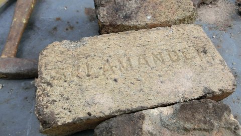 2016
 2016
 2016
 2014
 2012
 2010
 2010
 2010
 2010
 2010
 2008
 2008
 2005
