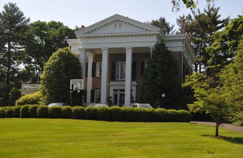
2 of Chatham Township’s places are on the National Register
Its Register listings are the Boisaubin Manor and the Gibbons, William, Stable and Farm. Most of Chatham Township was built recently: 7% of its homes predate 1940 and the median home dates from 1974. Below: 4 old photos and papers and maps from 1888 on.
Every edition of the U.S. Geological Survey’s map of Chatham Township. Tap a year, or press play to watch the town change.
1888Plainfield sheet · 1:62,500
U.S. Geological Survey historical topographic maps (public domain), via Esri’s collection of the scans. The red ring marks the center of Chatham Township.
Places that used to be
Lost post offices and old corners
Another post office, Long Hill, opened and closed inside today’s town.
Long Hill
1838–1905
Green Village
1862–today
18301930today
Hamlets and corners on the map
Floral HillGreen VillageHickory TreeLong Hill
US Post Offices dataset (Blevins & Helbock, CC0). Places and cemeteries from the USGS Geographic Names Information System (2021).
The newly established, post-Revolutionary War state of New Jersey went through several stages setting out how its local governments would be structured. Townships were drawn that included villages and open land. Once boroughs became available in New Jersey as a form of local government after 1878, between 1889 and 1899 Chatham Township lost all but one of the villages drawn into it, including Chatham (settled in 1710), which had been drawn into the new township in 1806. They seceded as soon as the bourough form of government became available.
Only Green Village, another early town that, like Chatham, dates to colonial times, was left under jurisdiction of "Chatham Township".
Founding dates: Wikidata, Wikipedia, the U.S. post office records of Blevins & Helbock (CC0) and the Census. Homes by year built: Census ACS 2020–24. National Register of Historic Places: National Park Service (list of May 22, 2026). Old photos, postcards and papers: Wikimedia Commons, the Library of Congress and other public archives, credited on each item’s page. Maps: U.S. Geological Survey historical topographic maps (via Esri) and Sanborn fire-insurance maps (Library of Congress). History text and census tables: Wikipedia (CC BY-SA 4.0). Places that used to be: USGS Geographic Names Information System (2021). How TownRatings grades history →
From the Library of Congress (4), the National Register of Historic Places (2), Wikipedia, U.S. Geological Survey historical maps, the US Post Offices dataset (Blevins & Helbock) and the USGS Geographic Names Information System. Archive images are copied here with their credits and licenses, shown on each photo’s page. Refreshed monthly.


 Date?
 Date?
 Date?
 Date?